Tierra Buena, California

Last updated

Tierra Buena
Sutter County California Incorporated and Unincorporated areas Tierra Buena Highlighted.svg
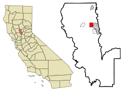
Location in Sutter County and the state of California
Coordinates: 39°8′59″N121°40′17″W / 39.14972°N 121.67139°W / 39.14972; -121.67139
Country Flag of the United States (23px).png  United States
State Flag of California.svg  California
County Sutter
Area
  Total8.9 km2 (3.4 sq mi)
  Land8.9 km2 (3.4 sq mi)
  Water0 km2 (0 sq mi)
Elevation
18 m (59 ft)
Population
 (2004)
  Total5,436
  Density515.4/km2 (1,349.1/sq mi)
Time zone UTC-8 (Pacific (PST))
  Summer (DST) UTC-7 (PDT)
95993
95993
Area code 530
FIPS code 06-78680
GNIS feature ID1659999

Tierra Buena (Spanish for "Good Land") was a census-designated place (CDP) in Sutter County, California, United States. It was part of the Yuba City Metropolitan Statistical Area within the Greater Sacramento CSA. The population was 4,587 at the 2000 census, and the CDP has a total area of 3.4 square miles (8.8 km2), all of it land.

Contents

The CDP was abolished prior to the 2010 census.

Demographics

As of the census [1] of 2000, there were 4,587 people, 1,598 households, and 1,289 families residing in the CDP. The population density was 1,336.4 inhabitants per square mile (516.0/km2). There were 1,650 housing units at an average density of 480.7 per square mile (185.6/km2). The racial makeup of the CDP was 75.84% White, 1.29% African American, 1.20% Native American, 11.49% Asian, 0.17% Pacific Islander, 5.91% from other races, and 4.10% from two or more races. Hispanic or Latino of any race were 10.62% of the population.

There were 1,598 households, of which 35.7% had children under the age of 18 living with them, 68.6% were married couples living together, 8.0% had a female householder with no husband present, and 19.3% were non-families. 14.8% of all households consisted of individuals, and 6.9% had someone living alone who was 65 years of age or older. The average household size was 2.87, and the average family size was 3.16.

In the CDP, the population was spread out, with 26.7% under the age of 18, 6.5% from 18 to 24, 26.8% from 25 to 44, 26.6% from 45 to 64, and 13.4% who were 65 years of age or older. The median age was 38 years. For every 100 females, there were 102.1 males. For every 100 females aged 18 and over, there were 97.8 males.

The median income for a household in the CDP was $52,358, and the median income for a family was $59,009. Males had a median income of $38,897 versus $30,372 for females. The per capita income for the CDP was $20,998. About 5.2% of families and 7.2% of the population were below the poverty line, including 9.5% of those under age 18 and 6.1% of those age 65 or over.

Media

MySYtv.com provides television coverage of local events in the area.

Additional information

Some parts of the Tierra Buena CDP have been annexed by the City of Yuba City since 2001 and are therefore within that city's official limits; however, some territory remains unincorporated.

Related Research Articles

<span class="mw-page-title-main">Sutter County, California</span> County in California, United States

Sutter County is a county located in the U.S. state of California. As of the 2020 census, the population was 99,633. The county seat is Yuba City. Sutter County is included in the Yuba City, CA Metropolitan Statistical Area as well as the Sacramento-Roseville, CA Combined Statistical Area. The county is located along the Sacramento River in the Sacramento Valley.

Rheems is an unincorporated community and census-designated place (CDP) in Lancaster County, Pennsylvania, United States, between the boroughs of Elizabethtown and Mount Joy. The population was 1,598 during the 2010 census.

<span class="mw-page-title-main">Buena Vista, San Jose</span> Neighborhood of San Jose in Santa Clara, California, United States

Buena Vista is a former census-designated place (CDP) in Santa Clara County, California, United States. The population was 1,704 at the 2000 census. The area is now part of the city of San Jose.

<span class="mw-page-title-main">South Yuba City, California</span> Unincorporated community in California, United States

South Yuba City is an unincorporated community and former census-designated place (CDP) in Sutter County, California, United States. It is part of the Yuba City Metropolitan Statistical Area within the Greater Sacramento CSA. The population was 12,651 at the 2000 census.

<span class="mw-page-title-main">Sutter, California</span> Census-designated place in California, United States

Sutter, formerly South Butte and Sutter City, is a census-designated place (CDP) in Sutter County, California, United States. It is part of the Yuba City Metropolitan Statistical Area within the Greater Sacramento CSA. The population as of the 2010 census was 2,904, up from 2,885 at the 2000 census.

<span class="mw-page-title-main">Linda, California</span> Census-designated place in California, United States

Linda is a census-designated place (CDP) in Yuba County, California, United States. The population was 17,773 at the 2010 census, up from 13,474 at the 2000 census. Linda is located 2 miles (3.2 km) north-northwest of Olivehurst.

<span class="mw-page-title-main">Loma Rica, California</span> Census-designated place in California, United States

Loma Rica is a census-designated place (CDP) in Yuba County, California, United States. The population was 2,368 at the 2010 census, up from 2,075 at the 2000 census. Loma Rica is located 15 miles (24 km) northeast of Marysville.

<span class="mw-page-title-main">Olivehurst, California</span> CDP in California, United States

Olivehurst is a census-designated place (CDP) in Yuba County, California, United States. The population was 13,656 at the 2010 census, up from 11,061 at the 2000 census. Olivehurst is located 4 miles (6.4 km) south-southeast of Marysville.

<span class="mw-page-title-main">Fort Myers Shores, Florida</span> Census-designated place in Florida, United States

Fort Myers Shores is an unincorporated community and census-designated place (CDP) in Lee County, Florida, United States. The population was 5,774 at the 2020 census, up from 5,487 at the 2010 census. It is part of the Cape Coral-Fort Myers, Florida Metropolitan Statistical Area.

<span class="mw-page-title-main">Buena Vista, Michigan</span> Place in Michigan, United States

Buena Vista is an unincorporated community and census-designated place (CDP) within Buena Vista Charter Township, Saginaw County in the U.S. state of Michigan. The U.S. Census Bureau has defined a census-designated place (CDP) with the same name for statistical purposes. The CDP has no official status as a municipality and the boundaries defined by the Census Bureau may not precisely correspond to local understanding of the Buena Vista area. The CDP consists of an area adjacent to the city of Saginaw on its east side and mostly east of Interstate 75. The population was 7,845 at the 2000 census.

<span class="mw-page-title-main">Challenge–Brownsville, California</span> Census-designated place in California, United States

Challenge–Brownsville is a census-designated place (CDP) in Yuba County, California, United States. The population was 1,161 according to the 2020 Census.

Stony Point is a census-designated place (CDP) in Sequoyah County, Oklahoma, United States. It is part of the Fort Smith, Arkansas-Oklahoma Metropolitan Statistical Area. The population was 177 at the 2000 census.

West Goshen was a census-designated place (CDP) in West Goshen Township, Chester County, Pennsylvania, United States. The population was 8,472 at the 2000 census. The CDP was not delineated for the 2010 census.

Jacksonville is a census-designated place (CDP) in Indiana County, Pennsylvania, United States. The population was 637 at the 2010 census. It was formerly an independent borough, until January 1, 1993 when it was returned to Black Lick Township, Pennsylvania.

<span class="mw-page-title-main">Sheppton, Pennsylvania</span> CDP in Pennsylvania, United States

Sheppton is a census-designated place (CDP) in Schuylkill County, Pennsylvania, United States. The population was 239 at the 2000 census.

<span class="mw-page-title-main">Tierra Bonita, Texas</span> Census-designated place in Texas, United States

Tierra Bonita is a census-designated place (CDP) in Cameron County, Texas, United States. The population was 179 at the 2020 census. It is part of the Brownsville–Harlingen Metropolitan Statistical Area.

<span class="mw-page-title-main">Tierra Grande, Texas</span> CDP in Texas, United States

Tierra Grande is a census-designated place (CDP) in Nueces County, Texas, United States. The population was 303 at the 2020 census, down from 403 in 2010.

<span class="mw-page-title-main">Bellwood, Virginia</span> CDP in Virginia, United States

Bellwood is a census-designated place (CDP) in Chesterfield County, Virginia, United States. The population was 6,352 at the 2010 census. The community takes its name from Bellwood, one of the James River Plantations.

<span class="mw-page-title-main">Tonawanda (CDP), New York</span> Census-designated place in New York, United States

Tonawanda is a census-designated place (CDP) in Erie County, New York, United States. The CDP comprises the town of Tonawanda minus its subsidiary village of Kenmore. As of the 2010 census, the CDP population was 58,144.

Buena Ventura Lakes, more commonly known as BVL, is a census-designated place (CDP) in northern Osceola County, Florida, United States, near Kissimmee. Its population was 26,079 at the 2010 census. It is part of the Orlando–Kissimmee–Sanford, Florida Metropolitan Statistical Area. The community is served by the Osceola Library System.

References

  1. "U.S. Census website". United States Census Bureau . Retrieved January 31, 2008.