
Cottage Grove is a city in Lane County, Oregon, United States. Its population was 10,643 at the 2020 census. It is the third largest city in Lane County. It is on Interstate 5, Oregon Route 99, and the main Willamette Valley line of the CORP railroad.

Shaniko is a city located in Wasco County, Oregon, United States, on U.S. Route 97 and about 8 miles (13 km) north of Antelope. The population was 30 at the 2020 census.

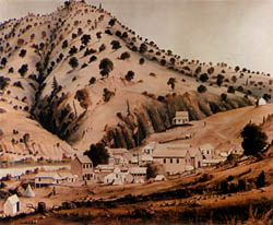
Bodie is a ghost town in the Bodie Hills east of the Sierra Nevada mountain range in Mono County, California, United States. It is about 75 miles (121 km) southeast of Lake Tahoe, and 12 mi (19 km) east-southeast of Bridgeport, at an elevation of 8,379 feet (2554 m). Bodie became a boom town in 1876 after the discovery of a profitable vein of gold; by 1879 it had established 2,000 structures with a population of roughly 8,000 people.

Dog Town is a gold rush era ghost town in Mono County, California. It is located at 38°10′13″N119°11′51″W, on Dog Creek, near the junction of Clearwater and Virginia Creeks, about 6 miles (10 km) south-southeast of Bridgeport, at an elevation of 7057 feet.
Bidwell's Bar was a gold mining camp in Butte County, California, United States, which lay at the end of the California Trail. It was located 6.5 miles (10.5 km) east-northeast of Oroville, at an elevation of 902 feet.

Waldo is a ghost town located in Josephine County, Oregon, United States, about three miles from the California border. It was settled in 1852 as a gold mining camp called Sailor's Diggings. The place was later renamed "Waldo" in honor of William Waldo, who in 1853 was the Whig candidate for governor of California. This was apparently because, believing the settlement was in California, William Waldo campaigned there and convinced the populace that they should vote for him. The town was the first county seat of Josephine County. The post office for Waldo was established in 1856; service was discontinued in 1928.
Greenwater was an unincorporated community near Death Valley located in the eastern side of the Inyo County, California. It is now a deserted ghost town.
Agua Fria is an unincorporated community in Mariposa County, California. It is located 5.25 miles (8.4 km) northeast of Catheys Valley, at an elevation of 2001 feet. Agua Fria is the former county seat of Mariposa County located approximately three miles west of Mariposa, California.
French Corral is an unincorporated community approximately five miles west of California State Highway 49 in Nevada County, California, United States.
Stewartville was an unincorporated place in eastern Contra Costa County, California that is now a ghost town. It was located 6 miles (10 km) northeast of Mount Diablo, at an elevation of 558 feet. It was a mining town for the nearby coal mines.
Greenville is a former settlement in Yuba County, California, United States. It was located on Little Oregon Creek 4.25 miles (6.8 km) southeast of Challenge, at an elevation of 2182 feet.
Blue Mountain City is a former settlement in Calaveras County, California, along Licking Fork, approximately 20 miles (32 km) northeast of Mountain Ranch. The town was built on a flat bench of land above the mining camp which perched on a steep canyon slope on the west side of Licking Fork, just over a mile downstream from the headwaters. The town was first announced in January, 1863. The Heckendorn Gold and Silver Mining Company was organized by July, with C. C. Bowman as its secretary. A post office operated in Blue Mountain from 1863 to 1864.

Bennettville is a former settlement and ghost town in Mono County, California. It was located on Mine Creek 4 mi (6.4 km) east-southeast of Mount Conness.
Bourne is a ghost town in Baker County, Oregon, United States about 7 miles (11 km) north of Sumpter in the Blue Mountains. It lies on Cracker Creek and is within the Wallowa–Whitman National Forest. Platted in 1902, the former gold mining boomtown is considered a ghost town today.

Susanville is an unincorporated community in Grant County, Oregon, United States, in the Blue Mountains about two miles up Elk Creek from Galena. The place was started as a gold mining camp in 1862 or 1864 and is now considered a ghost town.
Helena is a ghost town in unincorporated Trinity County, California, United States. It is located on the North Fork of the Trinity River, 10 miles (16 km) west-northwest of Weaverville. State Route 299 runs right past the former town to the south; East Fork Road connects the highway to Helena.

Como is a ghost town in Lyon County, Nevada, in the United States.


