Nord, California

Last updated

Nord
Aerial view of Nord (November 2023)-0102.jpg
Aerial view of Nord, November 2023
USA California location map.svg
Red pog.svg
Nord
Location in California
Coordinates: 39°46′47″N121°57′26″W / 39.77972°N 121.95722°W / 39.77972; -121.95722
Country Flag of the United States.svg  United States
State Flag of California.svg  California
County Butte County
Area
[1]
  Total2.105 sq mi (5.453 km2)
  Land2.105 sq mi (5.453 km2)
  Water0 sq mi (0 km2)
Elevation
[2]
151 ft (46 m)
Population
 (2020) [3]
  Total286
  Density140/sq mi (52/km2)
Time zone UTC-8 (Pacific (PST))
  Summer (DST) UTC-7 (PDT)
ZIP Code
95973
Area code 530
GNIS feature ID1659766; 2612484
U.S. Geological Survey Geographic Names Information System: Nord, California; U.S. Geological Survey Geographic Names Information System: Nord, California

Nord is a census-designated place [4] in Butte County, California. Its zip code is 95973 and its area code is 530. It lies at an elevation of 151 feet (46 m). Nord's population was 320 at the 2010 census.

Contents

History

A post office operated at Nord from 1871 to 1933, with an interruption from 1919 to 1920. [5]

Demographics

At the 2010 census Nord had a population of 320. The population density was 152.0 inhabitants per square mile (58.7/km2). The racial makeup of Nord was 233 (72.8%) White, 1 (0.3%) African American, 6 (1.9%) Native American, 16 (5.0%) Asian, 0 (0.0%) Pacific Islander, 48 (15.0%) from other races, and 16 (5.0%) from two or more races. Hispanic or Latino of any race were 122 people (38.1%). [6]

The whole population lived in households, no one lived in non-institutionalized group quarters and no one was institutionalized.

There were 104 households, 42 (40.4%) had children under the age of 18 living in them, 65 (62.5%) were opposite-sex married couples living together, 5 (4.8%) had a female householder with no husband present, 6 (5.8%) had a male householder with no wife present. There were 7 (6.7%) unmarried opposite-sex partnerships, and 1 (1.0%) same-sex married couples or partnerships. 19 households (18.3%) were one person and 7 (6.7%) had someone living alone who was 65 or older. The average household size was 3.08. There were 76 families (73.1% of households); the average family size was 3.61.

The age distribution was 83 people (25.9%) under the age of 18, 33 people (10.3%) aged 18 to 24, 79 people (24.7%) aged 25 to 44, 99 people (30.9%) aged 45 to 64, and 26 people (8.1%) who were 65 or older. The median age was 36.5 years. For every 100 females, there were 117.7 males. For every 100 females age 18 and over, there were 115.5 males.

There were 108 housing units at an average density of 51.3 per square mile (19.8/km2),of which 104 were occupied, 81 (77.9%) by the owners and 23 (22.1%) by renters. The homeowner vacancy rate was 0%; the rental vacancy rate was 4.2%. 247 people (77.2% of the population) lived in owner-occupied housing units and 73 people (22.8%) lived in rental housing units.

Government

County

State

The citizens of Nord, as constituents of California's 3rd Assembly District, are represented by Republican James Gallagher in the California State Assembly, [7] and as members of California's 4th Senate District, are represented by Democrat Marie Alvarado-Gil in the California State Senate. [8]

Federal

Nord is in California's 1st congressional district , represented by Republican Doug LaMalfa. [9]

Related Research Articles

<span class="mw-page-title-main">Avery, California</span> Census-designated place in California, United States

Avery is a census-designated place (CDP) in Calaveras County, California, United States. The population was 646 at the 2010 census, down from 672 at the 2000 census. Avery is located on State Route 4 and is home to the oldest continually operating hotel in the county, the Avery Hotel Restaurant & Saloon. Built in 1853, it was known as the "Half Way House," being located between Murphys, Arnold, and Calaveras Big Trees State Park.

<span class="mw-page-title-main">Forest Meadows, California</span> Census-designated place in California, United States

Forest Meadows is a census-designated place (CDP) in Calaveras County, California, United States. The population was 1,249 at the 2010 census, up from 1,197 at the 2000 census.

<span class="mw-page-title-main">Mesa, California</span> Census-designated place in California, United States

Mesa is a census-designated place (CDP) in Inyo County, California, United States. The population was 251 at the 2010 census, up from 214 at the 2000 census.

<span class="mw-page-title-main">Round Valley, California</span> Census-designated place in California, United States

Round Valley is a census-designated place (CDP) in Inyo County, California, United States. Round Valley is located 7.5 miles (12 km) northeast of Mount Tom, at an elevation of 4692 feet. The population was 435 at the 2010 census, up from 278 at the 2000 census.

<span class="mw-page-title-main">West Bishop, California</span> Census-designated place in California, United States

West Bishop is a census-designated place (CDP) in Inyo County, California, United States. The population was 2,607 at the 2010 census, down from 2,807 at the 2000 census.

<span class="mw-page-title-main">Desert View Highlands, California</span> Census designated place in California, United States

Desert View Highlands is a census-designated place (CDP) in Los Angeles County, California, United States. The population was 2,360 at the 2010 census, up from 2,337 at the 2000 census. It is surrounded by the City of Palmdale.

<span class="mw-page-title-main">Mayflower Village, California</span> Census-designated place in California, United States

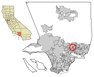
Mayflower Village is a census-designated place (CDP) in the San Gabriel Valley, in Los Angeles County, California, United States. The population was 5,515 at the 2010 census, up from 5,081 at the 2000 census. The ZIP Codes serving the community are 91006, which is served by Arcadia and 91016, which is served by Monrovia.

<span class="mw-page-title-main">Greenhorn, California</span> Census-designated place in California, United States

Greenhorn is a census-designated place (CDP) in Plumas County, California, United States. The population was 236 at the 2010 census, up from 146 at the 2000 census.

<span class="mw-page-title-main">Indian Falls, California</span> Census-designated place in California, United States

Indian Falls is a census-designated place (CDP) in Plumas County, California, United States. The population was 54 at the 2010 census, up from 37 at the 2000 census.

<span class="mw-page-title-main">Lake Almanor Peninsula, California</span> Census-designated place in California, United States

Lake Almanor Peninsula is a census-designated place (CDP) in Plumas County, California, United States. The population was 356 at the 2010 census, up from 336 at the 2000 census.

<span class="mw-page-title-main">Lake Almanor West, California</span> Census-designated place in California, United States

Lake Almanor West is a census-designated place (CDP) in Plumas County, California, United States. The population was 270 at the 2010 census, down from 329 at the 2000 census.

<span class="mw-page-title-main">Mohawk Vista, California</span> Census-designated place in California, United States

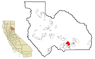
Mohawk Vista is a census-designated place in Plumas County, California, United States. The population was 159 at the 2010 census, up from 121 at the 2000 census.

<span class="mw-page-title-main">Prattville, California</span> Census-designated place in California, United States

Prattville is a census-designated place (CDP) in Plumas County, California, United States. The population was 24 at the 2020 census, down from 33 at the 2000 census.

<span class="mw-page-title-main">Spring Garden, California</span> Census-designated place in California, United States

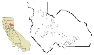
Spring Garden is a census-designated place (CDP) in Plumas County, California, United States. The population was 16 at the 2010 census, down from 55 at the 2000 census.

<span class="mw-page-title-main">Taylorsville, California</span> Census-designated place in California, United States

Taylorsville is a census-designated place (CDP) in Plumas County, California, United States. The population was 150 at the 2010 census, down from 154 at the 2000 census. The annual Stone Ranch Reunion is held in Taylorsville.

<span class="mw-page-title-main">Tobin, California</span> Census-designated place in California, United States

Tobin is a census-designated place (CDP) in Plumas County, California, United States. The population was 12 at the 2010 census, up from 11 at the 2000 census.

Clear Creek is a census-designated place (CDP) in Lassen County, California. It is located 2.5 miles (4 km) west-southwest of Westwood, at an elevation of 4970 feet. Its population is 175 as of the 2020 census, up from 169 from the 2010 census.

<span class="mw-page-title-main">California Pines, California</span> Census-designated place in California, United States

California Pines is a census-designated place in Modoc County, California. It lies at an elevation of 4406 feet. Its population is 473 as of the 2020 census, down from 520 from the 2010 census.

<span class="mw-page-title-main">Gold Mountain, California</span> Place in California, United States

Gold Mountain is an unincorporated community in Plumas County, California. Gold Mountain sits at an elevation of 5,341 feet (1,628 m). The 2010 United States census reported Gold Mountain's population was 80. For statistical purposes, the United States Census Bureau has defined Gold Mountain as a census-designated place (CDP).

Mabie is a census-designated place in Plumas County, California, USA. Mabie sits at an elevation of 5,341 feet (1,628 m). Mabie is located on the Western Pacific Railroad, 5 miles (8.0 km) east of Blairsden. The 2010 United States census reported Mabie's population was 161.

References

  1. "2010 Census U.S. Gazetteer Files – Places – California". United States Census Bureau.
  2. U.S. Geological Survey Geographic Names Information System: Nord, California
  3. "Nord CDP, California". United States Census Bureau . Retrieved August 30, 2023.
  4. U.S. Geological Survey Geographic Names Information System: Nord, California
  5. Durham, David L. (1998). California's Geographic Names: A Gazetteer of Historic and Modern Names of the State. Clovis, Calif.: Word Dancer Press. p. 285. ISBN   1-884995-14-4.
  6. "2010 Census Interactive Population Search: CA - Nord CDP". U.S. Census Bureau. Archived from the original on July 15, 2014. Retrieved July 12, 2014.
  7. "Members Assembly". State of California. Retrieved March 20, 2013.
  8. "Senators". State of California. Retrieved March 20, 2013.
  9. "California's 1st Congressional District - Representatives & District Map". Civic Impulse, LLC. Retrieved March 1, 2013.