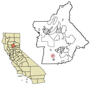
Biggs is a city in Butte County, California, United States. The population was 1,707 at the 2010 census, down from 1,793 at the 2000 census. The 2018 population estimate is 1,724.
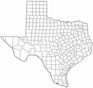
West Alto Bonito is a census-designated place (CDP) in Starr County, Texas, United States. The population was 696 in 2010 census. Prior to the 2010 census West Alto Bonito CDP was known as Alto Bonito CDP.

Ronald Arthur Biggs was an English criminal who helped plan and carry out the Great Train Robbery of 1963. He subsequently became notorious for his escape from prison in 1965, living as a fugitive for 36 years, and for his various publicity stunts while in exile. In 2001, Biggs returned to the United Kingdom and spent several years in prison, where his health rapidly declined. He was released from prison on compassionate grounds in August 2009 and died in a nursing home in December 2013.

The Sacramento Valley is the area of the Central Valley of the U.S. state of California that lies north of the Sacramento–San Joaquin River Delta and is drained by the Sacramento River. It encompasses all or parts of ten Northern California counties. Although many areas of the Sacramento Valley are rural, it contains several urban areas, including the state capital, Sacramento.
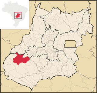
Caiapônia is a municipality in south-central Goiás state, Brazil. It has the third largest cattle herd in the state and is a major producer of grains. The town is also known as Torres Do Rio Bonito or just Rio Bonito.
Area code 530 is a California telephone area code in northeastern and Northern California.

Ryer Island is an island in the Sacramento-San Joaquin River Delta surrounded by Miner Slough and Steamboat Slough at their confluence with the Sacramento River, 6.5 miles north-northeast of Rio Vista. It is in Solano County, California, and managed by Reclamation District 501. The 4,750 ha (11,700-acre) island is named in honor of a California pioneer, Dr. Washington M. Ryer, and his family. A map prepared at the time of statehood shows the area divided by the west fork of the Sacramento River, with the western half identified as Priest Island and the eastern half identified as Sutter Island.
The Rio San Bernardino, or San Bernardino River, begins in extreme southeastern Cochise County, Arizona, and is a tributary of the Bavispe River, in Sonora, Mexico.

Richland is a former settlement in Butte County, California. It was located 3.5 miles (5.6 km) east-southeast of Biggs, at an elevation of 102 feet. It still appeared at its prior location on maps as of 1912 but moved half a mile (0.8 km) west by 1952.

Dos Rios is an unincorporated community in Mendocino County, California. It is located 7 miles (11 km) east-northeast of Laytonville, at an elevation of 961 feet. Dos Rios's zip code, 95429, has a population of 70.
Rio Bonito do Iguaçu is a municipality in the state of Paraná in the Southern Region of Brazil.
The Rio Bonito is a small river in the Sierra Blanca mountains of southern New Mexico, United States. The headwaters of the river start in the Lincoln National Forest on the slopes of Sierra Blanca and travel eastward until they merge with the south fork of the Rio Bonito just west of Bonito Lake, a man-made reservoir. After passing through the reservoir, the river continues in a generally eastward direction passing through the historic Fort Stanton and the home of Billy the Kid, Lincoln, New Mexico. 10 miles (16 km) past Lincoln the Rio Bonito merges with the Rio Ruidoso in the town of Hondo, New Mexico where the two rivers join to form the Rio Hondo which then flows towards the Pecos River. Though not reaching the Pecos except during floods.
The Rio Hondo is a 79-mile-long (127 km) river in southern New Mexico which begins at the confluence of the Rio Bonito and Rio Ruidoso rivers near the town of Hondo, New Mexico. The river flows eastward through the Hondo Valley in the foothills of the Sierra Blanca and Capitan Mountains, roughly paralleling the route of U.S. Route 70 through the towns of Picacho and Tinnie. Near the community of Riverside the river passes through a deep canyon before entering the rolling hills west of Roswell.

Hondo is an unincorporated community in Lincoln County, New Mexico, United States. It is located about five miles downstream (east) from Ruidoso Downs, where the Rio Bonito and Rio Ruidoso rivers join together to form the Rio Hondo. It is located at the point where U.S. Route 70 is joined by U.S. Route 380, which conjoined route continues eastward. It has had a post office since 1900.

The Microregion of Frederico Westphalen was one of the Microregions of the Rio Grande do Sul state, in Brazil. It belonged to the mesoregion of the Noroeste Rio-Grandense. Its population was estimated by the IBGE to be of 175,391 in 2005, divided in 27 municipalities. Its total area is of 5,182.529 km². The IBGE has since discontinued the microregion system for population tracking, replacing it with the term "immediate geographic region".

