
Butte County is a county located in the northern part of the U.S. state of California. In the 2020 census, its population was 211,632. The county seat is Oroville.

Glenn County is a county located in the U.S. state of California. As of the 2020 census, the population was 28,917. The county seat is Willows. It is located in the Sacramento Valley, in the northern part of the California Central Valley. The Grindstone Rancheria, reservation of the Grindstone Indian Rancheria of Wintun-Wailaki Indians, is located in Glenn County.
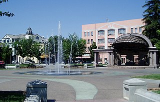
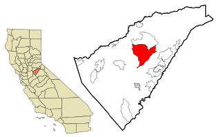
Chico is the most populous city in Butte County, California, United States. Located in the Sacramento Valley region of Northern California, the city had a population of 101,475 in the 2020 census, reflecting an increase from 86,187 in the 2010 Census. Chico is the cultural and economic center of the northern Sacramento Valley, as well as the largest city in California north of the capital city of Sacramento. The city is known as a college town, as the home of California State University, Chico, and for Bidwell Park, one of the largest urban parks in the world.
Mountain Ranch is a census-designated place (CDP) in Calaveras County, California, United States. The population was 1,628 at the 2010 census, up from 1,557 at the 2000 census. The town is registered as California Historical Landmark #282. The town center is quite small with fewer than 50 people living in it. The 5 mile square area surrounding the town accounts for the balance of the population.

Butte College is a public community college in the Butte-Glenn Community College District in Chico and Orland, California.

Calpella is an unincorporated community and census-designated place (CDP) in Mendocino County, California, United States. It is located on the Russian River, 6 miles (10 km) north of Ukiah. It is situated within the Ukiah Valley, at the intersection of U.S. Route 101 and State Route 20. The population was 799 at the 2020 census, up from 679 in 2010. The small town is the site of the Mendocino Redwood Company mill and offices, which controls ten percent of the private land in the county.

Cohasset is a census-designated place in Butte County, California, United States, approximately 17.7 miles (28.5 km) NNE of Chico, California. Its main street is named Cohasset Road, which comes from the Algonquian Indian language and means "long rocky place". The population was 847 at the 2010 census.
Yuba College is a public community college in Marysville, Yuba County, California. It is part of the Yuba Community College District.
Nord is a census-designated place in Butte County, California. Its zip code is 95973 and its area code is 530. It lies at an elevation of 151 feet. Nord's population was 320 at the 2010 census.

Coutolenc is a former settlement in Butte County, California, that was located 8.5 miles (13.7 km) northeast of Paradise.

Little Chico Creek is a perennial stream in Butte County, California. It descends the Sierra Nevada foothills from a spring off Headwaters Road in Forest Ranch, CA, flowing westward into the Parrot Grant which is just south of Ord Ferry Road and west of Seven Mile Lane where it just disappears.


