"},"named_for":{"wt":"Cleaton Grimes\n"},"unit_pref":{"wt":"US"},"area_footnotes":{"wt":"{{Cite web\n | url = http://www2.census.gov/geo/docs/maps-data/data/gazetteer/2010_place_list_06.txt\n | publisher = [[United States Census Bureau]]\n | accessdate = March 26, 2015\n | title = 2010 Census Gazetteer Files – Places – California}}"},"area_total_sq_mi":{"wt":"2.261"},"area_total_km2":{"wt":"5.856"},"area_land_sq_mi":{"wt":"2.261"},"area_land_km2":{"wt":"5.856"},"area_water_sq_mi":{"wt":"0"},"area_water_km2":{"wt":"0"},"area_water_percent":{"wt":"0"},"elevation_footnotes":{"wt":"{{Cite GNIS|224619|Grimes}}"},"elevation_ft":{"wt":"46"},"elevation_m":{"wt":"14 \n"},"population_as_of":{"wt":"2010"},"population_total":{"wt":"391"},"population_density_km2":{"wt":"auto\n"},"timezone":{"wt":"[[Pacific Time Zone|Pacific (PST)]]"},"utc_offset":{"wt":"-8"},"timezone_DST":{"wt":"PDT"},"utc_offset_DST":{"wt":"-7\n"},"postal_code_type":{"wt":"[[ZIP code]]"},"postal_code":{"wt":"95950"},"area_code_type":{"wt":"[[North American Numbering Plan|Area code]]"},"area_code":{"wt":"[[Area code 530|530]]"},"blank_name":{"wt":"[[Federal Information Processing Standard|FIPS]] code"},"blank_info":{"wt":"{{FIPS|06|31288}}"},"blank1_name":{"wt":"[[Geographic Names Information System|GNIS]] feature IDs"},"blank1_info":{"wt":"{{GNIS4|224619}}, {{GNIS4|2583030}}"},"official_name":{"wt":""}},"i":0}}]}" id="mwBw">Census-designated place in California, United States
Grimes | |
---|---|
Coordinates: 39°04′28″N121°53′38″W / 39.07444°N 121.89389°W | |
Country | United States |
State | California |
County | Colusa County |
Post office | 1883 [1] |
Named for | Cleaton Grimes [1] |
Area | |
• Total | 2.261 sq mi (5.856 km2) |
• Land | 2.261 sq mi (5.856 km2) |
• Water | 0 sq mi (0 km2) 0% |
Elevation | 46 ft (14 m) |
Population (2010) | |
• Total | 391 |
• Density | 170/sq mi (67/km2) |
Time zone | UTC-8 (Pacific (PST)) |
• Summer (DST) | UTC-7 (PDT) |
ZIP code | 95950 |
Area code | 530 |
FIPS code | 06-31288 |
GNIS feature IDs | 224619, 2583030 |
Grimes (formerly Grimes Landing [1] ) is a census-designated place [4] in Colusa County, California on the Southern Pacific Railroad. It lies at an elevation of 46 feet (14 m). The two main roads that run through it are State Route 45 and Grimes-Arbuckle Road. Its ZIP code is 95950, and its area code is 530. Grimes's population was 296 at the 2020 U.S. Census.
The post office was established in 1883. [1] Grimes is named after Cleaton Grimes, who obtained the townsite land in 1844. [1]
The Cecil Ranch in Grimes is listed on the National Register of Historic Places, partly for the architecture of its architect-designed main house, built in 1909. [5]
Grimes is located near the Sacramento River, on Highway 45 between Colusa and Knight's Landing. There is a convenience store, a small post office, a public library, and an elementary school. The school features grades Kindergarten through 5th grade, however some years the school will take 6th graders due to its small student count. There is a boat landing on the river to the south of the town, which also serves as a restaurant for the community.
Census | Pop. | Note | %± |
---|---|---|---|
2010 | 391 | — | |
2020 | 296 | −24.3% | |
U.S. Decennial Census [6] 2010 [7] |
Grimes first appeared as a census designated place in the 2010 U.S. Census. [7]
The 2020 U.S. Census reported that Grimes had a population of 296. The population density was 172.9 inhabitants per square mile (66.8/km2). The racial makeup of Grimes was 284 (72.6%) White, 7 (1.8%) African American, 3 (0.8%) Native American, 1 (0.3%) Asian, 0 (0.0%) Pacific Islander, 65 (16.6%) from other races, and 31 (7.9%) from two or more races. Hispanic or Latino of any race were 196 persons (66.0%).
The Census reported that 391 people (100% of the population) lived in households, 0 (0%) lived in non-institutionalized group quarters, and 0 (0%) were institutionalized.
There were 130 households, out of which 48 (36.9%) had children under the age of 18 living in them, 73 (56.2%) were opposite-sex married couples living together, 13 (10.0%) had a female householder with no husband present, 5 (3.8%) had a male householder with no wife present. There were 10 (7.7%) unmarried opposite-sex partnerships, and 0 (0%) same-sex married couples or partnerships. 33 households (25.4%) were made up of individuals, and 12 (9.2%) had someone living alone who was 65 years of age or older. The average household size was 3.01. There were 91 families (70.0% of all households); the average family size was 3.70.
The population was spread out, with 120 people (30.7%) under the age of 18, 31 people (7.9%) aged 18 to 24, 96 people (24.6%) aged 25 to 44, 104 people (26.6%) aged 45 to 64, and 40 people (10.2%) who were 65 years of age or older. The median age was 33.6 years. For every 100 females, there were 96.5 males. For every 100 females age 18 and over, there were 97.8 males.
There were 145 housing units at an average density of 64.1 units per square mile (24.7 units/km2), of which 130 were occupied, of which 71 (54.6%) were owner-occupied, and 59 (45.4%) were occupied by renters. The homeowner vacancy rate was 4.1%; the rental vacancy rate was 9.2%. 210 people (53.7% of the population) lived in owner-occupied housing units and 181 people (46.3%) lived in rental housing units.
In the California State Legislature, Grimes is in the 4th Senate District , represented by Republican Marie Alvarado-Gil, [8] and the 4th Assembly District , represented by Democrat Cecilia Aguiar-Curry. [9]
In the United States House of Representatives, Grimes is in California's 3rd congressional district , represented by Republican Kevin Kiley. [10]
Arbuckle is a census-designated place (CDP) in Colusa County, California, United States. The population was 3,028 at the 2010 census, up from 2,332 at the 2000 census. Arbuckle is situated in the southerly portion of Colusa County, approximately 20 miles (32 km) southwest of the City of Colusa, the county seat. The town is characterized by single-family residences, multiple-family units, some mobile homes, and commercial activities. Land surrounding Arbuckle is agriculture including cultivated annual crops, and both active and unmaintained orchards. Various almond hullers may be found near the area. Regional access is provided by the north–south running Interstate 5, along with Old Highway 99 West running alongside Interstate 5.
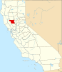
Colusa is a city and county seat of Colusa County, California, located in the Sacramento Valley region of the Central Valley. The population was 5,971 at the 2010 census, up from 5,402 at the 2000 census. Colusi originates from the local Coru Native American tribe, who in the 1840s lived on the opposite side of the Sacramento River.
Dixon Lane-Meadow Creek is a census-designated place (CDP) in Inyo County, California, United States. The population was 2,645 at the 2010 census, down from 2,702 at the 2000 census.
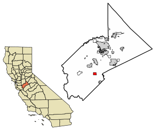
Boronda is an unincorporated community and census-designated place (CDP) in Monterey County, California, United States. The population was 1,760 at the 2020 census. Boronda is located directly west of Salinas and is named after José Eusebio Boronda, a Californio ranchero, and located on the lands of his Rancho Rincón del Sanjón.
North Auburn is a census-designated place (CDP) in Placer County, California, United States. It is part of the Sacramento–Arden-Arcade–Roseville Metropolitan Statistical Area. The population was 13,452 at the 2020 census.
Lake Davis is a census-designated place (CDP) in Plumas County, California, United States, located on Lake Davis. The population was 45 at the 2010 census.
El Cerrito is a census-designated place (CDP) in Riverside County, California, United States. It is an unincorporated area mostly surrounded by the city of Corona. The population was 5,100 at the 2010 census, up from 4,590 at the 2000 census.
Woodlake is a city in the San Joaquin Valley in Tulare County, California, United States. The population was 7,419 at the 2020 census, up from 7,279 at the 2010 census. In 1912, the city of Woodlake was founded by Gilbert F. Stevenson.
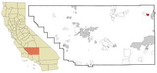
China Lake Acres is a census-designated place (CDP) in Kern County, California, United States. The population was 1,876 at the 2010 census, up from 1,761 at the 2000 census.
Martell is a census-designated place in Amador County, California, United States. It is located 1.5 miles (2.4 km) northwest of Jackson, at an elevation of 1486 feet. The population was 282 at the 2010 census.
Acampo is a small census-designated place (CDP) just north of Lodi in San Joaquin County, California, United States. In the 1870s, Acampo was named as a Southern Pacific Railroad station. Acampo's population was 341 at the 2010 census.
Maxwell is a census-designated place and farm community in Colusa County, California. It lies at an elevation of 92 feet. Located off Interstate 5, it is home to Maxwell High School. The main crop grown is rice, though a variety of others such as grapes, almonds, olives, squash, and sunflowers are grown as well. Its ZIP code is 95955 and its area code is 530. Maxwell's population was 1,103 at the 2010 census.
Stonyford is a census-designated place in Colusa County, California. It lies at an elevation of 1184 feet. Its zip code is 95979 and its area code is 530. Stonyford's population was 149 at the 2010 census.
Princeton is a census-designated place in Colusa County, California. It lies at an elevation of 82 feet. Its ZIP code is 95970 and its area code is 530. Princeton's population was 303 at the 2010 census.
College City is a census-designated place in Colusa County, California. It lies at an elevation of 72 feet (22 m) above sea level. Its ZIP code is 95912, and its area code is 530. Its population was 290 at the 2010 census.
Buckhorn is a census-designated place in Amador County, California. Buckhorn sits at an elevation of 3,238 feet. The community is in ZIP code 95666 and area code 209. The 2010 United States census reported Buckhorn's population was 2,429.
Lodoga is a census-designated place in Colusa County, California. It lies at an elevation of 1237 feet. Lodoga's population was 184 at the 2020 census.
Big Lagoon is a census-designated place in Humboldt County, California. It is located 7 miles (11 km) north of Trinidad, at an elevation of 56 feet (17 m). Its population is 161 as of the 2020 census, up from 93 from the 2010 census.
Crows Landing is a census-designated place (CDP) in Stanislaus County, California. Crows Landing is about 20 miles (32 km) southwest of Modesto. Crows Landing sits at an elevation of 128 feet (39 m). The 2020 United States census reported Crows Landing's population was 322.
North Gate is a census-designated place in Contra Costa County, California. North Gate sits at an elevation of 253 feet (77 m). The 2010 United States census reported North Gate's population was 679.