Geographical area of the United States, used in telephone service
Map of LATAs in the US
Local access and transport area (LATA) is a term used in U.S. telecommunications regulation. It represents a geographical area of the United States under the terms of the Modification of Final Judgment (MFJ) entered by the United States District Court for the District of Columbia in Civil Action number 82-0192 or any other geographic area designated as a LATA in the National Exchange Carrier Association, Inc. Tariff FCC No. 4. that precipitated the breakup of the original AT&T into the "Baby Bells" or created since that time for wireline regulation.
Generally, a LATA represents an area within which a divestedRegional Bell Operating Company (RBOC) is permitted to offer exchange telecommunications and exchange access services. Under the terms of the MFJ, the RBOCs are generally prohibited from providing services that originate in one LATA and terminate in another.
Originally, the LATAs were grouped into regions within which one particular RBOC was allowed to provide services. The LATAs in each of these regions are numbered beginning with the same digit. Generally, the LATAs were associated with carriers or other indications in the following manner:
In addition to this list, two local carriers were made independent: Cincinnati Bell in the Cincinnati area, and SNET (a former unit of AT&T, sold to Frontier) in Connecticut. These were assigned LATAs in the 9xx range.
Since the breakup of the Bell System in 1984, however, some amount of deregulation, as well as a number of phone company mergers, have blurred the significance of these regions. A number of new LATAs have been formed within these regions since their inception, most beginning with the digit 9.
LATAs contribute to an often confusing aspect of long-distance telephone service. Due to the various and overlapping regulatory limitations and inter-business arrangements, phone companies typically provide differing types of “long distance” service, each with potentially different rates:
within same LATA, within same state
within same LATA, between different states
between different LATAs, within same state
between different LATAs, between different states
Given the complexity of the legal and financial issues involved in each distinction, many long-distance companies tend to not explain the details of these different rates, which can lead to billing questions from surprised customers.
Local carriers have various alternative terms for LATAs such as “Service Area” by Pacific Bell in California, or “Regional Calling Area” by Verizon in Maryland.
To facilitate the sharing of Telcordia telephone routing databases between countries, LATAs were later defined for the provinces of Canada, the other countries and territories of the North American Numbering Plan, and Mexico. Aside from U.S. territories, LATAs have no regulatory purpose in these areas. In 2000, the Canadian Radio-television and Telecommunications Commission eliminated all Canadian provincial LATAs in favor of a single LATA for Canada (888).
No LATAs exist with a second digit of 0 or 1, which distinguished them from traditional area codes.
List of LATAs
US state LATAs
The city or place name given with some LATAs is the name given to identify the LATA, not the limit of its boundary. Generally this is the most significant metropolitan area in the LATA. In some cases, a LATA is named after the largest phone exchange in the LATA that was historically served by an RBOC. For example, the largest city in the Pahrump LATA in Nevada is Las Vegas. Since Las Vegas was not historically served by an RBOC, the LATA is named after the smaller town of Pahrump, which was historically served by Nevada Bell (now AT&T Inc.). Also, listing under a state does not necessarily limit the LATA's territory to that state; there may be overlaps as well as enclaves. Areas that include notable portions of other states are explained, but not all LATA state overlaps may be detailed.
LATA boundaries are not always solidly defined. Inter-carrier agreements, change proposals to the Federal Communications Commission (FCC), and new wiring developments into rural areas can and do often alter the effective borders between LATAs. Many sources on LATA boundary information conflict with each other at detailed levels. Telcordia data may provide the most up-to-date details of LATA inclusions.
Florida is a special case in which state regulators have also assigned 5-digit LATA codes which overlay the Federally-assigned 3-digit LATAs. See map on the right for details. Some carriers refer to these by the 3-digit LATA, others by the 5-digit.
As LATAs exist for US regulatory purposes, where they serve as a demarcation between intra-LATA calls (handled by regional Bell operating companies) and inter-LATA calls (handled by interstate long-distance carriers such as AT&T), they have no legal significance in Canada.
As of 2000, all of Canada (except for non-geographic numbers) is identified as LATA 888.
The use of this LATA set to identify individual provinces is therefore deprecated:
Canada does define local interconnection regions (LIR's), which determine where points of interconnection (POI) must be provided by competing local exchange and mobile carriers to provide local number portability.[4] A Canadian LIR is geographically smaller than a US LATA, typically comparable in size to a small city's flat-rate local calling area or to an entire large regional municipality. In areas where a small-city Digital Multiplex System controls a group of remote switching centres, one for each surrounding village, the local interconnect region normally includes each exchange in the city plus all downstream remotes of those exchanges.[5] In a Toronto-sized city, the LIR will include only the city itself.
While the LIRs resemble local calling areas in geographic size, there are some key differences:
LIR's normally do not include incumbent local independent telephone company exchanges in locations not opened to competition, where the independent numbers are currently not portable.
LIR's do not cross provincial boundaries. Lloydminster has an LIR for each province, as does Ottawa-Hull.
LIR's closely follow network topology, which often does not match a local flat-rate calling area as local calling is defined by arbitrary regulatory constructs.
One example: The tiny unincorporated village of Beebe Plain, divided by the Quebec-Vermont border, is served by +1-819-876 Rock Island, Quebec, Canada (a remote station controlled from Magog) and +1-802-873 Derby Line, Vermont, USA (a remote station controlled from St. Johnsbury). Magog and St. Johnsbury are both a long-distance call from anywhere in Beebe Plain, even though Canadian subscribers can place local calls to Sherbrooke, US subscribers can locally call Newport and an international call within the village is local. An LIR assignment which follows network topology places the Canadian remote station in Magog's LIR, not Sherbrooke's LIR.[6]
1 2 Half of LATA 636 occupies eastern North Dakota, the other half takes up the northwest quarter of Minnesota.
↑ LATA 228 includes all of Delaware as well as the metro area of Philadelphia, Pennsylvania.
↑ American Samoa entered the NANP in October 2004 and presumably was allocated a LATA by that time. Telcordia LERG data suggests that American Samoa uses LATA 884.
Local exchange carrier (LEC) is a regulatory term in telecommunications for the local telephone company.
Regional Bell Operating Company (RBOC) was a corporate entity created as result of the antitrust lawsuit by the U.S. Department of Justice against the American Telephone and Telegraph Company (AT&T) in 1974 and settled in the Modification of Final Judgment on January 8, 1982.
The Nine Nations of North America is a 1981 book by Joel Garreau, in which the author suggests that North America can be divided into nine nations, which have distinctive economic and cultural features. He also argues that conventional national and state borders are largely artificial and irrelevant, and that his "nations" provide a more accurate way of understanding the true nature of North American society. The work has been called "a classic text on the current regionalization of North America".
411 is a telephone number for local directory assistance in Canada and the United States. Until the early 1980s, 411 – and the related 113 number – were free to call in most jurisdictions.
A civil township is a widely used unit of local government in the United States that is subordinate to a county, most often in the northern and midwestern parts of the country. The term town is used in New England, New York, as well as Wisconsin to refer to the equivalent of the civil township in these states; Minnesota uses "town" officially but often uses it and "township" interchangeably. Specific responsibilities and the degree of autonomy vary in each state. Civil townships are distinct from survey townships, but in states that have both, the boundaries often coincide, especially in Indiana, Ohio, and Illinois, and may completely geographically subdivide a county. The U.S. Census Bureau classifies civil townships as minor civil divisions. Currently, there are 20 states with civil townships, including Indiana, Ohio, Illinois, Michigan, Iowa, Minnesota, Wisconsin, Missouri, Kansas, Nebraska, South Dakota, North Dakota, Pennsylvania, and West Virginia.
The North American Central Time Zone (CT) is a time zone in parts of Canada, the United States, Mexico, Central America, and some Caribbean islands.
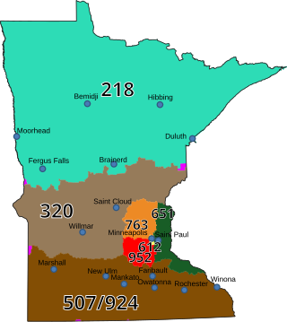
Area code 218 is a telephone area code in the North American Numbering Plan (NANP) for the northern part of the U.S. state of Minnesota. It is assigned to the largest of Minnesota's original two numbering plan areas (NPAs), although its geographical boundaries have been modified since inception. It comprises roughly the northern half of the state, and includes the cities of Duluth, Hibbing, Brainerd, Bemidji, Fergus Falls, and Moorhead.
Tri-state area is an informal term in the United States which can refer to any of multiple areas that lie across three states. When referring to populated areas, the term implies a shared economy or culture among the area's residents, typically concentrated around a central metropolis.
Area codes 514, 438, and 263 are telephone area codes of the North American Numbering Plan (NANP) for Montreal and most of its on-island suburbs, specifically the Island of Montreal and Île Perrot in the Canadian province of Quebec.
The Central United States is sometimes conceived as between the Eastern and Western as part of a three-region model, roughly coincident with the U.S. Census Bureau's definition of the Midwestern United States plus the western and central portions of the U.S. Census's definition of the Southern United States. The Central States are typically considered to consist of North Dakota, South Dakota, Nebraska, Kansas, Oklahoma, Texas, Minnesota, Iowa, Missouri, Arkansas, Louisiana, Wisconsin, Illinois, Michigan, Indiana, Ohio, Kentucky, Tennessee, West Virginia, Mississippi and Alabama.
Area code 859 is a telephone area code in the North American Numbering Plan (NANP) for the city of Lexington and the central portion of the Commonwealth of Kentucky. It was created in a split from area code 606 in 1999.
The following is a set–index article, providing a list of lists, for the cities, towns and villages within the jurisdictional United States. It is divided, alphabetically, according to the state, territory, or district name in which they are located.
The Bell System was a system of telecommunication companies, led by the Bell Telephone Company and later by the American Telephone and Telegraph Company (AT&T), that dominated the telephone services industry in North America for over 100 years from its creation in 1877 until its antitrust breakup in 1983. The system of companies was often colloquially called Ma Bell, as it held a vertical monopoly over telecommunication products and services in most areas of the United States and Canada. At the time of the breakup of the Bell System in the early 1980s, it had assets of $150 billion and employed over one million people.
In the administration of the North American Numbering Plan, central office code protection is a numbering policy for maintaining local seven-digit dialing in communities that extend on both sides of the boundary line between multiple numbering plan areas (NPAs), such as in cross-border towns on state lines. Code protection prevents the use of the same telephone number on both sides by not assigning the same central office code of one NPA in the adjacent NPA.
This page is based on this Wikipedia article Text is available under the CC BY-SA 4.0 license; additional terms may apply. Images, videos and audio are available under their respective licenses.