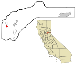
Penn Valley | |
---|---|
Coordinates: 39°11′54″N121°11′20″W / 39.19833°N 121.18889°W | |
Country | United States |
State | California |
County | Nevada |
Area | |
• Total | 2.121 sq mi (5.495 km2) |
• Land | 2.121 sq mi (5.495 km2) |
• Water | 0 sq mi (0 km2) 0% |
Elevation | 1,401 ft (427 m) |
Population (2010) | |
• Total | 1,621 |
• Density | 760/sq mi (290/km2) |
Demonym | Penn Valleyian [2] |
Time zone | UTC-8 (Pacific (PST)) |
• Summer (DST) | UTC-7 (PDT) |
ZIP code | 95946 |
Area code | 530 |
FIPS code | 06-56518 |
GNIS feature ID | 1867050 |
Penn Valley is a census-designated place (CDP) in Nevada County, California. The population was 1,621 at the 2010 census, up from 1,387 at the 2000 census. The large Lake Wildwood master-planned community, although a separate CDP, has a Penn Valley postal address, and is sometimes considered part of the general Penn Valley community.
The community may be named for Madame Penn, the original owner of the town site. [3]
Penn Valley is located at 39°11′54″N121°11′20″W / 39.19833°N 121.18889°W (39.198214, -121.188965). [4]
According to the United States Census Bureau, the CDP has a total area of 2.1 square miles (5.4 km2), all of it land.
The 2020 United States Census reported that Penn Valley had a population of 1,593. There were 665 housing units. There were 478 households.
The 2010 United States Census [5] reported that Penn Valley had a population of 1,621. The population density was 764.1 inhabitants per square mile (295.0/km2). The racial makeup of Penn Valley was 1,434 (88.5%) White, 9 (0.6%) African American, 34 (2.1%) Native American, 23 (1.4%) Asian, 0 (0.0%) Pacific Islander, 31 (1.9%) from other races, and 90 (5.6%) from two or more races. Hispanic or Latino of any race were 143 persons (8.8%).
The Census reported that 1,611 people (99.4% of the population) lived in households, 10 (0.6%) lived in non-institutionalized group quarters, and 0 (0%) were institutionalized.
There were 628 households, out of which 195 (31.1%) had children under the age of 18 living in them, 301 (47.9%) were opposite-sex married couples living together, 91 (14.5%) had a female householder with no husband present, 41 (6.5%) had a male householder with no wife present. There were 36 (5.7%) unmarried opposite-sex partnerships, and 3 (0.5%) same-sex married couples or partnerships. 163 households (26.0%) were made up of individuals, and 74 (11.8%) had someone living alone who was 65 years of age or older. The average household size was 2.57. There were 433 families (68.9% of all households); the average family size was 3.02.
The population was spread out, with 363 people (22.4%) under the age of 18, 136 people (8.4%) aged 18 to 24, 321 people (19.8%) aged 25 to 44, 506 people (31.2%) aged 45 to 64, and 295 people (18.2%) who were 65 years of age or older. The median age was 44.5 years. For every 100 females, there were 93.7 males. For every 100 females age 18 and over, there were 89.2 males.
There were 666 housing units at an average density of 313.9 per square mile (121.2/km2), of which 485 (77.2%) were owner-occupied, and 143 (22.8%) were occupied by renters. The homeowner vacancy rate was 2.6%; the rental vacancy rate was 3.3%. 1,186 people (73.2% of the population) lived in owner-occupied housing units and 425 people (26.2%) lived in rental housing units.
As of the census [6] of 2000, there were 1,387 people, 530 households, and 383 families residing in the CDP. The population density was 659.3 inhabitants per square mile (254.6/km2). There were 561 housing units at an average density of 266.7 per square mile (103.0/km2). The racial makeup of the CDP was 93.4% White, 0.8% African American, 0.6% Native American, 0.7% Asian, 5.5% from other races, and 2.4% from two or more races. Hispanic or Latino of any race were 12.5% of the population.
There were 530 households, out of which 32.8% had children under the age of 18 living with them, 55.3% were married couples living together, 12.1% had a female householder with no husband present, and 27.7% were non-families. 20.6% of all households were made up of individuals, and 9.4% had someone living alone who was 65 years of age or older. The average household size was 2.62 and the average family size was 3.03.
In the CDP, the population was spread out, with 27.0% under the age of 18, 4.8% from 18 to 24, 26.2% from 25 to 44, 26.3% from 45 to 64, and 15.6% who were 65 years of age or older. The median age was 40 years. For every 100 females, there were 95.9 males. For every 100 females age 18 and over, there were 93.5 males.
The median income for a household in the CDP was $35,962, and the median income for a family was $37,115. Males had a median income of $33,068 versus $21,133 for females. The per capita income for the CDP was $16,582. About 9.2% of families and 13.0% of the population were below the poverty line, including 22.7% of those under age 18 and 6.6% of those age 65 or over.
In the state legislature, Penn Valley is in the 1st Senate District , represented by Republican Brian Dahle, [7] and the 1st Assembly District , represented by Republican Megan Dahle. [8]
Federally, Penn Valley is in California's 1st congressional district , represented by Republican Doug LaMalfa. [9]
Penn Valley hosts a rodeo event each year in late Spring and has attracted as many as 5,000 spectators during one of its events. [10] The Penn Valley Rodeo is organized by Penn Valley Community Rodeo Association since 2005. [11] In the 1950s, the Penn Valley Fire Dept. needed funds. George Alan Smith, a local cowboy and heavy equipment operator, came up with the idea of holding a rodeo. George talked Pegar (of Pegar's 'Y') into donating the land, and then he leveled and build the grounds with his D-9 CAT bull-dozer. George enlisted the help of friends and relatives on weekends, evenings, and holidays to set posts, build fence and chutes, and put up bleachers. George, a WWII Navy Vet, was the nephew of Jay and Bessie Peacock, owners of the Peacock Ranch (at the top of Pet Hill). In 1951, he married Lynn Margaret Gleason, daughter of Harold & Mildred Gleason who owned the Lazy Valley Angus Ranch, which was the original stage stop between Reno and Sacramento during the Gold Rush. As they built the arena, George and Lynn organized the weekend calf-ropings there. Lynn and other ropers' wives put together a refreshment stand, and their children collected pop bottles under the bleachers, turning them in for the refunds. All of this served to work out any problems with the arena before the big event. The first Penn Valley Rodeos featured intermission entertainment provided by local rancher, Larry Filer and his horse, Jim. Larry claimed that he never trained Jim, and that Jim initiated all his humorous antics. Jim would pull the handkerchief out of Larry's back pocket, count, play dead, take a nap and steal the covers, steal Larry's hat, etc. The first rodeo was a success, and it took on a life of its own. The local Fire Department and residents volunteered their time and efforts to help put on the annual event. The Penn Valley Rodeo quickly became "the summer event" for people from all over California to attend. [12]
Bear Valley is a census-designated place in Alpine County, California, best known as the location of the Bear Valley ski area. The population was 121 at the 2010 census, down from 133 at the 2000 census.
Rodeo is a census-designated place (CDP) located in Contra Costa County, California, in the East Bay sub-region of the San Francisco Bay Area, on the eastern shore of San Pablo Bay, 25 miles northeast of San Francisco. The population was 9,653 at the 2020 census. The town is named for the rodeos common in the late 19th century. Cattle from the surrounding hills were regularly driven down through the old town to a loading dock on the shoreline of San Pablo Bay for shipment to slaughterhouses, a practice which continued through the early 20th century. The town of Rodeo is served by the Interstate 80 freeway and State Route 4. The Southern Pacific Railroad main line passes through Rodeo. Rodeo has not been a stop on the railroad since the 1950s.
Bowles is a census-designated place (CDP) in Fresno County, California, United States. The population was 166 at the 2010 census, down from 182 at the 2000 census. Bowles is located 11 miles (18 km) south of downtown Fresno, at an elevation of 279 feet.
Bear Valley Springs is a guarded-gate community in Kern County, California, United States. The unincorporated community is in the Tehachapi Mountains and is part of the greater Tehachapi area. The elevation ranges from 4,121 feet (1,256 m) to 6,934 feet (2,113 m). The population fluctuates between a low during the winter months when snow is common, to a high in the summer months when its elevation keeps it much cooler than surrounding areas and major cities. The population was 5,172 at the 2010 census, up from 4,232 at the 2000 census. For statistical purposes, the United States Census Bureau has defined Bear Valley Springs as a census-designated place (CDP). The census definition of the area may not precisely correspond to local understanding of the area with the same name.
Valinda is a census-designated place (CDP) in the San Gabriel Valley, in Los Angeles County, California, in the United States. At the 2010 census, the population was 22,822, up from 21,776 at the 2000 census.
Tamalpais-Homestead Valley is a census-designated place (CDP) in Marin County, California, United States. The population was 11,492 at the 2020 census.
Le Grand is an unincorporated community and census-designated place (CDP) in Merced County, California, United States. Le Grand is 14 miles (23 km) east-southeast of Merced, the county seat at an elevation of 253 feet (77 m). The population was 1,592 at the 2020 census, down from 1,659 at the 2010 census.
Boronda is an unincorporated community and census-designated place (CDP) in Monterey County, California, United States. The population was 1,760 at the 2020 census. Boronda is located directly west of Salinas and is named after José Eusebio Boronda, a Californio ranchero, and located on the lands of his Rancho Rincón del Sanjón.
Lake Wildwood is a census-designated place (CDP) in Nevada County, California, United States. The population was 4,991 at the 2010 census, up from 4,868 at the 2000 census.
Meadow Vista is a census-designated place (CDP) in Placer County, California, United States. It is part of the Sacramento–Arden-Arcade–Roseville Metropolitan Statistical Area. The population was 3,217 at the 2010 census, up from 3,096 at the 2000 census.
Twain is a census-designated place (CDP) in Plumas County, California, United States. As of the 2020 census, the CDP population was 303, up from 82 at the 2010 census.
Rainbow is a census designated place (CDP) in northern San Diego County in the U.S. state of California. The population was 1,832 at the 2010 census, down from 2,026 at the 2000 census.
Taft Mosswood is a census-designated place (CDP) in San Joaquin County, California, United States. The population was 1,530 at the 2010 census, up from 1,388 at the 2000 census. It comprises an unincorporated "island" within the City of Stockton.
Aptos Hills-Larkin Valley is an unincorporated community in Santa Cruz County, California, United States. It is identified as one of several small communities with a combined population of 24,402 forming the unincorporated town of Aptos by the local Chamber of Commerce along with:
Day Valley is a census-designated place (CDP) in Santa Cruz County, California, United States. The population was 3,409 at the 2010 census.
Live Oak is a census-designated place (CDP) in Santa Cruz County, California between the cities of Santa Cruz and Capitola and north of the former Union Pacific railroad. Live Oak sits at an elevation of 102 feet (31 m). The population was 17,038 at the 2020 census. The population of the greater Live Oak area, including Twin Lakes and Pleasure Point, was 27,921.
Green Valley is a census-designated place (CDP) located in Solano County, California, United States. It sits in the northeast corner of the San Francisco Bay Area and is located approximately 45 miles (72 km) from Sacramento, approximately 38 miles (61 km) from San Francisco, approximately 32 miles (51 km) from Oakland, less than 15 miles (24 km) from Napa Valley, and less than 15 miles (24 km) from both the Carquinez Bridge and the Benicia Bridge.
Poplar-Cotton Center is a census-designated place (CDP) in Tulare County, California, United States. The population was 2,470 at the 2010 census, up from 1,496 at the 2000 census.
Challenge–Brownsville is a census-designated place (CDP) in Yuba County, California, United States. The population was 1,161 according to the 2020 Census.
Searles Valley is a census-designated place (CDP) in the Searles Valley of the Mojave Desert, in northwestern San Bernardino County, California.