
Nevada County is a county located in the U.S. state of California, in the Sierra Nevada. As of the 2020 census, its population was 102,241. The county seat is Nevada City. Nevada County comprises the Truckee-Grass Valley micropolitan statistical area, which is also included in the Sacramento-Roseville combined statistical area, part of the Mother Lode Country.

Northern California is a geographic and cultural region that generally comprises the northern portion of the U.S. state of California. Spanning the state's northernmost 48 counties, its main population centers include the San Francisco Bay Area, the Greater Sacramento area, the Redding, California, area south of the Cascade Range, and the Metropolitan Fresno area. Northern California also contains redwood forests, along with most of the Sierra Nevada, including Yosemite Valley and part of Lake Tahoe, Mount Shasta, and most of the Central Valley, one of the world's most productive agricultural regions.

The Black Rock Desert is a semi-arid region of lava beds and playa, or alkali flats, situated in the Black Rock Desert–High Rock Canyon Emigrant Trails National Conservation Area, a silt playa 100 miles (160 km) north of Reno, Nevada that encompasses more than 300,000 acres (120,000 ha) of land and contains more than 120 miles (200 km) of historic trails. It is in the northern Nevada section of the Great Basin with a lakebed that is a dry remnant of Pleistocene Lake Lahontan.

The Walker River is a river in west-central Nevada in the United States, approximately 62 miles (100 km) long. Fed principally by snowmelt from the Sierra Nevada of California, it drains an arid portion of the Great Basin southeast of Reno and flows into the endorheic basin of Walker Lake. The river is an important source of water for irrigation in its course through Nevada; water diversions have reduced its flow such that the level of Walker Lake has fallen 160 feet (49 m) between 1882 and 2010. The river was named for explorer Joseph Reddeford Walker, a mountain man and experienced scout who is known for establishing a segment of the California Trail.

Tioga Pass is a mountain pass in the Sierra Nevada mountain range of California. State Route 120 runs through it, and serves as the eastern entry point for Yosemite National Park, at the Tioga Pass Entrance Station. It is the highest elevation highway pass in California and in the Sierra Nevada at an elevation of 9,945 ft (3,031 m). Mount Dana is to the east of the pass, and Gaylor Peak to the west.
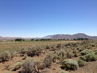
Denio is a census-designated place (CDP) in Humboldt County, Nevada, along the Oregon state line in the United States. The Denio post office was originally north of the state line in Harney County, Oregon, but the residents moved the building into Nevada in the mid-20th century. The population of the CDP, which is entirely in Nevada, was 47 at the 2010 census; additional development considered to be Denio extends into Oregon. The CDP includes a post office, a community center, a library, and the Diamond Inn Bar, the center of the town's social life. Recreational activities in the Denio area include bird watching, photography, off road vehicle use, fishing, recreational black opal mining, rockhounding, hunting, visiting the hot springs, and camping on the Sheldon National Wildlife Refuge.

Kent Island is a small island in Marin County, California. In 1964, it was proposed for large-scale development including a hotel and marina, but the plan was defeated in 1967. The island is now included in the Greater Farallones National Marine Sanctuary.

According to the California Protected Areas Database (CPAD), in the state of California, United States, there are over 14,000 inventoried protected areas administered by public agencies and non-profits. In addition, there are private conservation areas and other easements. They include almost one-third of California's scenic coastline, including coastal wetlands, estuaries, beaches, and dune systems. The California State Parks system alone has 270 units and covers 1.3 million acres (5,300 km2), with over 280 miles (450 km) of coastline, 625 miles (1,006 km) of lake and river frontage, nearly 18,000 campsites, and 3,000 miles (5,000 km) of hiking, biking, and equestrian trails.

The landlocked U.S. state of Nevada has a varied geography and is almost entirely within the Basin and Range Province and is broken up by many north–south mountain ranges. Most of these ranges have endorheic valleys between them.

The Sheldon National Wildlife Refuge is a 573,504-acre (232,089 ha) national wildlife refuge on the northern border of the U.S. state of Nevada. A very small part extends northward into Oregon. It is managed by the United States Fish and Wildlife Service (USFWS) as the Nevada component of the Sheldon-Hart Mountain National Wildlife Refuge Complex, which is headquartered in Lakeview, Oregon. The Sheldon Refuge was noted for its population of wild horses, now all removed.
Cedar Ridge is an unincorporated community in Nevada County, California, United States, along State Route 174 2.5 miles (4.0 km) east/southeast of Grass Valley, California. and approximately 1 mile (1.6 km) east/southeast of the Empire Mine in Gold Country. The first Post Office was established in 1948 and the zip code is 95924.
Chicago Park is a residential and unincorporated historic agricultural community in Nevada County, California. It is located along Highway 174, with its center at the intersection of Mt. Olive Road. The neighborhood gets its name from its founding residents, who came from Chicago to California in the late 1800s to grow fruit, which was often shipped back to Illinois for consumption. Chicago Park is about 9 miles southeast of Grass Valley and about 3 miles north of Colfax.

The following outline is provided as an overview of and topical guide to the U.S. state of Nevada:
Eagle Bird is a former settlement in Nevada County, California. Situated at an elevation of 3,350 ft (1,020 m) above sea level, it still appeared on maps as of 1902. Eagle Bird is located on the South Yuba River, 6.25 miles (10.1 km) south-southeast of Graniteville.
Maybert was a mining town in Nevada County, California. It was located on the south side of the South Yuba River, about 6 miles east of the town of Washington, at an elevation of 3,245 ft (989 m). Fall Creek empties into the South Yuba slightly to the northwest of the town site.
Union Hill is a former settlement in Nevada County, California, 1.5 mi (2.4 km) from Grass Valley. Its elevation is 2,700 ft (820 m) above sea level.
Sunset View is a former settlement in Nevada County, California, located near Grass Valley. It was listed on an official map as of 1949.
Hunt's Hill is a former mining camp in Nevada County, California, United States. Hunt's Hill was located in the Sierra Nevada foothills about 6 miles in a straight line southeast of Nevada City and about 2 miles northwest of You Bet, on the north side of Greenhorn Creek, not far from the present intersection of Red Dog and Buckeye Roads. Hunt's Hill was founded in 1852 by a miner named Hunt. It was located on one of the deepest parts of the rich Blue Lead channel of gold-bearing gravel. In 1855, one of the mining claims established by some French miners, was “jumped". During the fight, one of the French miners lost an eye. Thereafter, that mine, and sometimes the town, were called Gouge Eye. By 1857, the town boasted two saloons, a hotel, a blacksmith and stable, a butcher shop, a boot and shoe store, and several grocery stores. In 1858, a stage line from Nevada City arrived. In 1866, seven cement mills for extracting gold from the “blue cement” were operating in the area. By 1880, the town was reduced to a combined store and saloon and a few houses. In 1895, one directory summed up the state of the community thus: "At the present time there is not much doing there." Since that same directory identified the town's justice of the peace and constable, what little happened must have been interesting. Today, it is just a historic site.
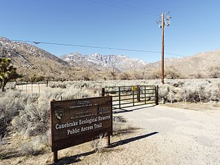
Canebrake Ecological Reserve is a 6,700-acre (27 km2) nature reserve in the South Fork Valley of Kern County, 20 miles (32 km) east of Lake Isabella, California. It is located in the Southern Sierra Nevada region.

