Malakoff is a city in Henderson County, Texas, United States. The population was 2,324 at the 2010 census. The city is named after a Russian fort of Malakoff, which played a pivotal role during the siege of Sevastopol during the Crimean War.

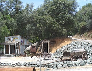
Malakoff Diggins State Historic Park is a state park unit preserving the largest hydraulic mining site in California, United States. The mine was one of several hydraulic mining sites at the center of the 1882 landmark case Woodruff v. North Bloomfield Mining and Gravel Company. The mine pit and several Gold Rush-era buildings are listed on the National Register of Historic Places as the Malakoff Diggins-North Bloomfield Historic District. The "canyon" is 7,000 feet (2,100 m) long, as much as 3,000 feet (910 m) wide, and nearly 600 feet (180 m) deep in places. Visitors can see huge cliffs carved by mighty streams of water, results of the mining technique of washing away entire mountains of gravel to wash out the gold. The park is a 26-mile (42 km) drive north-east of Nevada City, California, in the Gold Rush country. The 3,143-acre (1,272 ha) park was established in 1965.

South Yuba River State Park is located along the South Fork of the Yuba River in the Sierra Nevada, within Nevada County, in Northern California.

Volcano is a census-designated place in Amador County, California. It lies at an elevation of 2070 feet. The population was 115 at the 2010 census. It is located at 38°26′35″N120°37′51″W, just north of Pine Grove. The town is registered as a California Historical Landmark. The community is in ZIP code 95689 and area code 209.

Jenny Lind is an unincorporated community in Calaveras County, California. It lies at an elevation of 253 feet and is located at 38°6′N120°52′W. The community is in ZIP code 95252 and area code 209.
Rough and Ready is a census-designated place in Nevada County, California, United States. It is located west of Grass Valley, California, approximately 62 miles (100 km) from Sacramento. The population was 963 at the 2010 census. It has frequently been noted on lists of unusual place names.
Merrimac is an unincorporated community in Butte County, California located along Oroville-Quincy Road about 2.1 miles (3.4 km) south of the Plumas County line. It lies at an elevation of 3999 feet. While the location is shown as official in the National Geographic Names Database, it is not known if locals use this name to describe the place today. Nearby is Rogers Cow Camp, a campground in Lassen National Forest. The USGS feature ID for this populated place is 1659117. The US Postal Service does not show a ZIP Code for this community. The location is within area code 530.

French Corral is an unincorporated community approximately five miles west of California State Highway 49 in Nevada County, California.
The San Juan Ridge is a geographic feature extending approximately 24 miles (39 km) east-northeast between the South and Middle Yuba Rivers in the foothills of the northern Sierra Nevada. The elevation is approximately 790 m (2,600 ft) above sea level.
North Columbia was a California Gold Rush town on the San Juan Ridge in Nevada County, California. Originally known as Columbia, Columbia Hill, or The Hill because of its proximity to Columbia Hill, it started as a gold miners' camp around 1851. When a Post Office was established on May 29, 1860, the word "North" was added in order to differentiate the settlement from Columbia, California, another gold rush town in Tuolumne County, California.

North San Juan is a census-designated place in Nevada County, California, United States, along State Route 49 on the San Juan Ridge in Gold Country. The zip code is 95960. The population was 269 at the 2010 census.

The North Bloomfield Mining and Gravel Company of North Bloomfield, California, was established in 1866 and operated a hydraulic gold-mining operation at the Malakoff Mine subsequent to the California Gold Rush. In its day, no other company's operations matched North Bloomfield Mining and Gravel Company in size or expense. The company operated until 1910. In the years prior, its profits and procedures had been reduced due to the landmark ruling of Woodruff v. North Bloomfield Gravel Mining Company.
Lake City is an unincorporated community in Nevada County, California, United States, east of North Columbia, California and west of North Bloomfield, California
Omega was a former settlement in Nevada County, California, United States, first populated in 1850 by a single miner, J.A. Dixon, working a claim during the California Gold Rush. The town was located 3.25 miles (5.2 km) east-southeast of the present-day unincorporated town of Washington, California. A sister town, Alpha, located at what is now the site of the historical Omega Hydraulic Diggings, was about 1 mi (1.6 km) north of Omega. In the mid 1850s, following the introduction of hydraulic mining operations nearby, the town prospered. Omega had a post office, and needed to convert a residence into a jail in late 1858.
Birchville is a historic mining and agricultural community in Nevada County, California. Birchville is located about 10 miles northwest of Nevada City and about 2 miles northeast of French Corral. It is situated at an elevation of 1,765 ft (538 m) above sea level.

The Holbrooke Hotel is located in Grass Valley, California, USA. It is notable as the oldest hotel that has been in continuous operation in California's Mother Lode. The hotel was built in 1862 in mid-19th century Mother Lode masonry architectural style, and incorporated the Golden Gate Saloon which has been in continuous operation since 1852.

The 65.0-mile-long (104.6 km) South Yuba River is a left-entering tributary of the Yuba River originating in the northern Sierra Nevada at Lake Angela in Nevada County about three quarters of a mile north of Donner Pass, about three miles east of the town of Soda Springs. After passing through Lake Van Norden with Upper Castle Creek entering from the right, it gathers numerous snow-fed tributaries running west through a marshy, lake-filled valley, criss-crossing Interstate 80. The river briefly enters Placer County, then flows into Lake Spaulding, then plunges westward into a steep-sided valley. Canyon Creek enters from the right, then Poorman Creek also from the right near the town of Washington. The river continues west into the foothills, crossing under State Route 49. Its mouth is on the east shore of upper Englebright Lake, formed by a dam across the Yuba River.
Malakoff Diggings may refer to: