Related Research Articles

Nevada County is a county located in the U.S. state of California, in the Sierra Nevada. As of the 2020 census, its population was 102,241. The county seat is Nevada City. Nevada County comprises the Truckee-Grass Valley micropolitan statistical area, which is also included in the Sacramento-Roseville combined statistical area, part of the Mother Lode Country.

Grass Valley is a city in Nevada County, California, United States. Situated at roughly 2,500 feet (760 m) in elevation in the western foothills of the Sierra Nevada mountain range, this northern Gold Country city is 57 miles (92 km) by car from Sacramento, 64 miles (103 km) from Sacramento International Airport, 88 miles (142 km) west of Reno, and 143 miles (230 km) northeast of San Francisco. As of the 2010 United States Census, its population was 12,860.

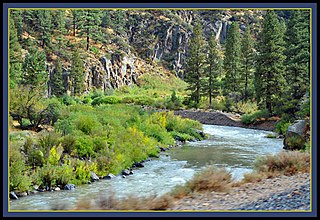
The Feather River is the principal tributary of the Sacramento River, in the Sacramento Valley of Northern California. The river's main stem is about 73 miles (117 km) long. Its length to its most distant headwater tributary is just over 210 miles (340 km). The main stem Feather River begins in Lake Oroville, where its four long tributary forks join—the South Fork, Middle Fork, North Fork, and West Branch Feather Rivers. These and other tributaries drain part of the northern Sierra Nevada, and the extreme southern Cascades, as well as a small portion of the Sacramento Valley. The total drainage basin is about 6,200 square miles (16,000 km2), with approximately 3,604 square miles (9,330 km2) above Lake Oroville.
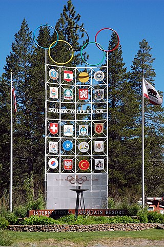
Olympic Valley is an unincorporated community located in Placer County, California northwest of Tahoe City along California State Highway 89 on the banks of the Truckee River near Lake Tahoe. It is home to Palisades Tahoe, the site of the 1960 Winter Olympics. Olympic Valley is the smallest resort area to host the Olympic Winter Games.

Loch Leven is the name of several lakes in California, United States, in the Sierra Nevada.

Central California is generally thought of as the middle third of the state, north of Southern California, which includes Los Angeles, and south of Northern California, which includes San Francisco. It includes the northern portion of the San Joaquin Valley, part of the Central Coast, the central hills of the California Coast Ranges and the foothills and mountain areas of the central Sierra Nevada.

Sierra Valley is a large mountain valley located west of the crest of California's Sierra Nevada mountain range in Plumas and Sierra Counties, north of Interstate 80.
French Corral is an unincorporated community approximately five miles west of California State Highway 49 in Nevada County, California.
Emigrant Pass may refer to:

Santa Susana Pass State Historic Park is a California State Park of 670.68 acres (2.7141 km2) located in the city of Los Angeles, in Los Angeles County on the boundary between Ventura and Los Angeles counties, between the communities of Chatsworth and Simi Valley. Geologically, the park is located where the Simi Hills meet the Santa Susana Mountains. Here in the western part of the Transverse Ranges, the land is dominated by high, narrow ridges and deep canyons covered with an abundant variety of plant life. The park offers panoramic views of the rugged natural landscape as a striking contrast to the developed communities nearby. The park is also rich in archaeological, historical, and cultural significance.
Fairhaven is an unincorporated community in Frederick County, Maryland, United States.

Camp Richardson is an unincorporated community at Lake Tahoe, in El Dorado County, California. It lies at an elevation of 6250 feet in the Sierra Nevada.
Hayes or Hayes Station is a former settlement in Fresno County, California. It was located 18 miles (29 km) southwest of Mendota, next to Silver Creek and slightly northeast of that waterway's junction with Panoche Creek. The Panoche road exit on I-5 lies about one mile ENE of the location.

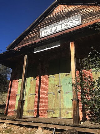
The Nevada County Narrow Gauge Railroad (NCNGRR) was located in Northern California's Nevada County and Placer County, where it connected with the Central Pacific Railroad. The Nevada County Narrow Gauge Railroad Company incorporated on April 4, 1874, and was headquartered in Grass Valley, California. After two years of construction, passenger and commercial rail services began in 1876 and continued until 1943. The 22.53 mi (36.26 km) line ran from Colfax, north through Grass Valley to Nevada City. At one time, the railroad was notable for having the highest railroad bridge in California, the Bear River Bridge, built in 1908.
Floriston is an unincorporated community and census-designated place in Nevada County, California. It is situated at an elevation of 5,400 ft (1,600 m) above sea level. Floriston is located on the Truckee River, 10 miles (16.1 km) east-northeast of Truckee. Formerly an important railroad stop and mill town, Floriston survives to this day as a small residential community. The population was 73 at the 2010 census.

Martis Valley is a geographic area of 70 square miles (180 km2) in the United States, extending northward from the North Shore of Lake Tahoe, California, to the west of the California-Nevada border. It is located in Placer and Nevada Counties and is bisected by Martis Creek which flows north to the Truckee River.
Golfland Entertainment Centers are a chain of family amusement centers, miniature golf courses, and water parks located in California and Arizona. The company was founded in 1953.
Hue is an unincorporated community in Swan Township, Vinton County, Ohio, in the United States.

Webster was an unincorporated community in Belmont Township, Rooks County, Kansas, United States.
Lamb is an extinct town in Marion County, in the U.S. state of Missouri. The GNIS classifies it as a populated place.
References
- ↑ California Maps: Carpenter Valley in Nevada County, California, http://californiamaps.org/place.php?county=Nevada&feature=Carpenter+Valley, and California Hometown Locator: Carpenter Valley (in Nevada County, CA), http://california.hometownlocator.com/maps/feature-map,ftc,1,fid,257994,n,carpenter%20valley.cfm, retrieved 26 Aug 2009.
- ↑ Erwin G. Gudde: California Place Names, The Origin and Etymology of Current Geographical Names, University of California Press, Berkeley and Los Angeles, 1960, p. 52.

Coordinates: 39°23′13″N120°15′24″W / 39.38694°N 120.25667°W
| | This Nevada County, California-related article is a stub. You can help Wikipedia by expanding it. |