Sacramento is the capital city of the U.S. state of California and the county seat of Sacramento County. Located at the confluence of the Sacramento and American Rivers in Northern California's Sacramento Valley, Sacramento's 2020 population of 524,943 makes it the fourth-most populous city in Northern California, sixth-most populous city in the state, and the ninth-most populous state capital in the United States. Sacramento is the seat of the California Legislature and the Governor of California.

The Central Valley is a broad, elongated, flat valley that dominates the interior of California. It is 40–60 mi (60–100 km) wide and runs approximately 450 mi (720 km) from north-northwest to south-southeast, inland from and parallel to the Pacific coast of the state. It covers approximately 18,000 sq mi (47,000 km2), about 11% of California's land area. The valley is bounded by the Coast Ranges to the west and the Sierra Nevada to the east.

Grass Valley is a city in Nevada County, California, United States. As of the 2010 United States Census, its population was 12,860. Situated at roughly 2,500 feet (760 m) in elevation in the western foothills of the Sierra Nevada mountain range, this northern Gold Country city is 57 miles (92 km) by car from Sacramento and 88 miles (142 km) west of Reno.

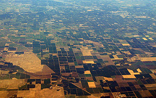
The Sacramento Valley is the area of the Central Valley of the U.S. state of California that lies north of the Sacramento–San Joaquin River Delta and is drained by the Sacramento River. It encompasses all or parts of ten Northern California counties. Although many areas of the Sacramento Valley are rural, it contains several urban areas, including the state capital, Sacramento. Since 2010, statewide droughts in California have further strained both the Sacramento Valley's and the Sacramento metropolitan region's water security.

The Sacramento Bee is a daily newspaper published in Sacramento, California, in the United States. Since its foundation in 1857, The Bee has become the largest newspaper in Sacramento, the fifth largest newspaper in California, and the 27th largest paper in the U.S. It is distributed in the upper Sacramento Valley, with a total circulation area that spans about 12,000 square miles (31,000 km2): south to Stockton, California, north to the Oregon border, east to Reno, Nevada, and west to the San Francisco Bay Area.

State Route 174 is a state highway in the U.S. state of California. The two-lane 13-mile (21 km) highway in the western Sierra Nevada, added to the state highway system in 1933, connects Interstate 80 in Colfax with SR 20/SR 49 in Grass Valley, crossing the Bear River next to a 1924 concrete arch bridge. The majority of the route is eligible for the State Scenic Highway System, but local residents have blocked its designation due to property right concerns.
California's 3rd congressional district is a U.S. congressional district in California. It includes the northern Sierra Nevada and northeastern suburbs of Sacramento, stretching south to Death Valley. It encompasses Alpine, Inyo, Mono, Nevada, Placer, Plumas, and Sierra counties, as well as parts of El Dorado, Sacramento, and Yuba counties. It includes the Sacramento suburbs of Roseville, Folsom, Orangevale, Rocklin, and Lincoln, and the mountain towns of Quincy, South Lake Tahoe, Truckee, Mammoth Lakes, and Bishop. The district is represented by Republican Kevin Kiley.
Garden Valley is an unincorporated community in El Dorado County, California. It is located on Johntown Creek 6.25 miles (10 km) north-northwest of Chili Bar, at an elevation of 1949 feet.
Outingdale is an unincorporated community in El Dorado County, California. It is located on the Middle Fork of the Cosumnes River 4 miles (6.4 km) north of Aukum, at an elevation of 1624 feet.

Newville is an unincorporated community in Glenn County, California. It is located 18 miles (29 km) west of Orland, at an elevation of 623 feet.
Spenceville was a ranching, farming and mining community located in the southwestern part of Nevada County, California, on Spenceville Road just east of Waldo Road, about 17 miles from Grass Valley. Its elevation was about 400 feet. The former townsite is now part of the Spenceville Wildlife Area.
Jerseydale is an unincorporated community in Mariposa County, California. It is located 9 miles (14 km) south-southwest of El Portal, at an elevation of 3779 feet.

Patrick Manogue was an Irish-born prelate of the Catholic Church in America. He served as the founding bishop of the Diocese of Sacramento in California from 1886 until his death in 1895. He previously served as bishop of the Diocese of Grass Valley in California from 1881 until 1886.

Amerish Babulal "Ami" Bera is an American physician and politician who has been serving as a member of the United States House of Representatives from California since 2013. He is a member of the Democratic Party and represents California's 6th congressional district, which is in Sacramento County.
Casa Loma is an unincorporated community in Placer County, California. Casa Loma is located 3.25 miles (5.2 km) east of Dutch Flat. It lies at an elevation of 4032 feet.
Loybas Hill is an unincorporated community in Tehama County, in the U.S. state of California. According to the Geographic Names Information System, the community is on the west side of the Sacramento River and 4.6 miles southeast of the city of Corning.

The 2020 California State Senate election was held on Tuesday, November 3, 2020, with the primary election scheduled for March 3, 2020. Voters in the 20 odd-numbered districts of the California State Senate elected their representatives. The elections coincided with the elections for other offices, including for U.S. President and the state assembly.

The 2022 California State Controller election was held on November 8, 2022, to elect the California State Controller. Due to term limits, incumbent Democratic Controller Betty Yee was ineligible to run for a third term. Democrat Malia Cohen won the election, defeating Republican Lanhee Chen. Despite Chen's loss, the race was the closest of the 2022 elections in California and Chen received more votes than any Republican candidate in the 2022 national election cycle. Chen flipped ten counties, also the most any candidate flipped in California.

The 49er Fire was a destructive wildfire in September 1988 in California's Nevada County and Yuba County. The fire was ignited on the morning of September 11, when a homeless schizophrenic man accidentally set brush on fire by burning toilet paper. Driven by severe drought conditions and strong, dry winds, firefighting crews were hard-pressed to stop the fire's advance until winds calmed and humidity levels recovered. It burned 33,700 acres throughout the foothills of the Sierra Nevada, impinging on the communities of Lake Wildwood, Rough and Ready, and Smartsville before officials declared it fully contained on September 16.


