French Corral, California

Last updated

French Corral
French Corral.jpg
An old Wells Fargo Bank building in French Corral
USA California location map.svg
Red pog.svg
French Corral
Location of French Corral in California
Coordinates: 39°18′22″N121°09′41″W / 39.30611°N 121.16139°W / 39.30611; -121.16139
Country Flag of the United States.svg  United States
State Flag of California.svg  California
County Nevada
Elevation
[1]
1,532 ft (467 m)
Time zone UTC-8 (Pacific (PST))
  Summer (DST) UTC-7 (PDT)
Area code 530

French Corral is an unincorporated community approximately five miles west of California State Highway 49 in Nevada County, California, United States.

Contents

It was one of the first of several historic California gold rush mining camps along the San Juan Ridge. The name was literal as the town grew around a mule corral built by the first settler in the area, a Frenchman, in 1849. [2] It had a post office during the period of 1859 through 1945. [3]

Few original structures remain besides an old Wells Fargo Bank building. [4]

Location

Based on roads and trails used during its time, French Corral was located between the small towns of Rough & Ready and North San Juan. [5] On a present-day map, French Corral is located in the extreme northwest corner of Nevada County, California. [6] Originally, French Corral was part of the nearby Bridgeport Township, the third locality in the county in terms of population and wealth during the mining years. [7]

French Corral is part of a thermal belt that runs from the town site to the Bear River along the lower foothills of the western part of Nevada County. This allowed citrus crops to be successfully grown in the area from the 1870s well into the 1920s. [8] Due to the accommodating soil and climate, early French settlers of the area planted vineyards and produced local wines. [9]

Founding

French Corral's name is self-descriptive in that in 1849 a Frenchman living on Frenchman's Bar on the Yuba River built a mule corral on the site that would later become the town. [10] At about the same time, a Mr. Galloway established a trading post near by. Originally in a tent, it was upgraded to a log building. [11] In 1851 the town showed up as Frenchmans Couill on a Milleson & Adams map, and by 1857 the town was shown as French Corral on Goddard's map. [12] At some point during this timeframe, the locals tried to rename the town Carrolton, but the new name never stuck and it remained French Corral.

Mining and, to a lesser extent, agriculture both drove the boom in French Corral. By the 1850s it was an important town between the growing gold-rush hubs of Grass Valley and Nevada City, and rural North San Juan. [13] [14]

History

The town thrived for several decades, by the early 1850s French Corral had a population of 300-400 residents. [15] In 1852 a Post Office was established and by 1859 a horse express to the nearby town of North San Juan was introduced. Supported by the continuing mining opportunities, by the 1880s there were two hotels, one store, a saloon, a bakery, four blacksmiths, two carpenters, a physician, and many homes in French Corral. Helping to continue the vibrancy of the town was a stage line from North San Juan to Marysville in Yuba County that routed through French Corral. [6]

By mid 1853 the town boasted approximately 70 homes. Unfortunately, within a short time fire destroyed 50 of them. Fire would continue to plague the town with destruction and rebuilding becoming a regular part of life for the residents. [16]

Beginning in 1855, the male citizens of French Corral consistently cast votes in national and state elections [7] and volunteered for the Bridgeport Guards, a protective organization. [6] During the Civil War, the town contributed $300 to the “sanitary fund” for the Union Army. [7]

Founded, and sustained to a great extent by individuals from France or of French ancestry, the town retained a Gallic influence, becoming a major grape-growing region in Nevada County. Many citizens maintained contact with their mother country. For example, in 1870, the town collected and donated $192 to the French victims of the Franco-Prussian War. [17]

As was unfortunately commonplace in the surrounding mining towns, the residents of French Corral drove out the local Chinese residents and burned down many of their homes in 1867. A trial later determined that one individual was the “instigator,” but most accomplices went unpunished. [6]

Mining

French Corral's current condition contradicts its prolific past. Having "resounded to the tread of the prospector," [6] the town enjoyed both a placer boom and a hydraulic mining boom. The area existed as a successful mining region from 1849 well into the 1900s. [18]

Ravine mining began in the area in 1849, with surface diggings discovered around 1851. [7] More sophisticated mining practices started in early 1852, with the building of a ditch from Shady Creek by the Messrs, Twist, Wadsworth, Williams, Spurry, and the Eddy brothers. [16] Another Shady Creek ditch was built in 1853, brought in by the Grizzly Water Company and principally owned by Charles Marsh and W.M. Stewart. Several fires damaged the facilities, but profitable mining continued, with more ditches and deeper tunnels being built throughout the 1850s. [19]

The gold mined in the 1850s in the French Corral area was estimated in the millions of dollars. [7]

As hydraulic mining took over, several large mines were established near French Corral, including the Manzanita Mine operated by the Milton Company. By 1880, the company had 160 men on the payroll. Several men became wealthy through these mining practices. Those men included A.H. Eddy, the eventual owner of the National Exchange Hotel in Nevada City, W.G. Fenton, M.L. Marsh, and Jean Villian. [6]

Hydraulic mining lasted until the 1884 prohibition of discharging mining debris into the Yuba River. In 1894, however, the U.S. Debris Commission granted limited hydraulic mining to the French Corral region. [8]

Interestingly, diamonds of notable size and brilliance were also found in French Corral. It was said that "bigger and better diamonds have been found at French Corral, in Nevada County, than in any other place in California." [20]

First Long-Distance Phone Line

See First long-distance telephone line

The world's first long-distance telephone line was built in 1878 by the Ridge Telephone Company. It connected French Corral with French Lake, approximately 60 miles away, and it was operated by the Milton Mining Company. This historic accomplishment is memorialized by California State Historic Marker #247 near the center of the physical remains of French Corral on Pleasant Valley Road. [19]

Geography

French Corral is located at 39°18′22″N121°09′37″W / 39.30611°N 121.16028°W / 39.30611; -121.16028 , and the elevation is 1,532 feet (467 m) above sea level. [21]

Climate

According to the Köppen Climate Classification system, French Corral has a warm-summer Mediterranean climate, abbreviated "Csa" on climate maps. [22]

Demographics

In 1880, the population was 527. [23]

Historical landmarks

Related Research Articles

<span class="mw-page-title-main">Nevada County, California</span> County in California, United States

Nevada County is a county located in the U.S. state of California, in the Sierra Nevada. As of the 2020 census, its population was 102,241. The county seat is Nevada City. Nevada County comprises the Truckee-Grass Valley micropolitan statistical area, which is also included in the Sacramento-Roseville combined statistical area, part of the Mother Lode Country.

<span class="mw-page-title-main">Gold Country</span> Historic gold-mining region in Northern California

The Gold Country is a historic region in the northern portion of the U.S. state of California, that is primarily on the western slope of the Sierra Nevada. It is famed for the mineral deposits and gold mines that attracted waves of immigrants, known as the 49ers, during the 1849 California Gold Rush.

<span class="mw-page-title-main">Malakoff Diggins State Historic Park</span> State Historic Park

Malakoff Diggins State Historic Park is a state park unit preserving Malakoff Diggins, the largest hydraulic mining site in California, United States. The mine was one of several hydraulic mining sites at the center of the 1882 landmark case Woodruff v. North Bloomfield Mining and Gravel Company. The mine pit and several Gold Rush-era buildings are listed on the National Register of Historic Places as the Malakoff Diggins-North Bloomfield Historic District. The "canyon" is 7,000 feet (2,100 m) long, as much as 3,000 feet (910 m) wide, and nearly 600 feet (180 m) deep in places. Visitors can see huge cliffs carved by mighty streams of water, results of the mining technique of washing away entire mountains of gravel to wash out the gold. The park is 26 miles (42 km) north-east of Nevada City, California, in the Gold Rush country. The 3,143-acre (1,272 ha) park was established in 1965.

<span class="mw-page-title-main">Yuba River</span> Waterway in Northern California

The Yuba River is a tributary of the Feather River in the Sierra Nevada and eastern Sacramento Valley, in the U.S. state of California. The main stem of the river is about 40 miles (64 km) long, and its headwaters are split into three major forks. The Yuba River proper is formed at the North Yuba and Middle Yuba rivers' confluence, with the South Yuba joining a short distance downstream. Measured to the head of the North Yuba River, the Yuba River is just over 100 miles (160 km) long.

<span class="mw-page-title-main">Graniteville, California</span> Unincorporated community in California, United States

Graniteville is a small, unincorporated community and census-designated place (CDP) located in Nevada County, California, United States. The town sits on the San Juan ridge separating the Middle and South Forks of the Yuba River, approximately 26 miles (42 km) northeast of Nevada City. The elevation of Graniteville is 4,977 feet (1,517 m) above sea level. As of the 2010 census, Graniteville had a population of 11.

<span class="mw-page-title-main">San Juan Ridge</span>

The San Juan Ridge is a geographic feature extending approximately 24 miles (39 km) east-northeast between the South and Middle Yuba Rivers in the foothills of the northern Sierra Nevada. The elevation is approximately 790 m (2,600 ft) above sea level.

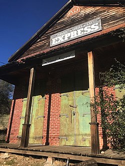
Lake City is an unincorporated community in Nevada County, California. It lies at an elevation of 3300 ft. about 10 miles northeast of Nevada City as the crow flies, and about three miles southeast of North Columbia, and three miles southwest of North Bloomfield. It is located at the junction of modern day North Bloomfield, Back Bone and Lake City Roads. It was an important mining and transportation center in the second half of the 19th century.

Moore's Flat was a historic mining town located on the San Juan Ridge about 19 miles northeast of Nevada City, California and about 5 miles northeast of North Bloomfield, California. The town was about 1 mile south of the Middle Yuba at an elevation of about 4200 ft. On either side of it, lay the mining towns of Orleans Flat and Woolsey's Flat, each about I mile apart. All three were settled around 1851 and their histories frequently intertwine. Collectively, they are sometimes referred to as "The Flats." All three were part of Eureka Township.

Orleans Flat was a historic mining town located on the San Juan Ridge about 20 miles northeast of Nevada City, California and about 5 miles northeast of North Bloomfield, California. The town was about 1 mile south of the Middle Yuba River at an elevation of about 4200 ft. To the west lay the mining towns of Moore's Flat and Woolsey's Flat, each about I mile apart. All three were settled around 1851 and their histories frequently intertwine. Collectively, they are sometimes referred to as "The Flats." All three were part of Eureka Township.

Woolsey Flat or Woolsey's Flat was a historic mining town located on the San Juan Ridge, located about 17 miles northeast of Nevada City and about 3 miles northeast of North Bloomfield. The town was about 1 mile south of the Middle Yuba at an elevation of about 4200 ft. To the east lay the mining towns of Moore's Flat and Orleans Flat, each about I mile apart. All three were settled in 1851 and their histories frequently intertwine. Collectively, they are sometimes referred to as "The Flats. All three were part of Eureka Township.

Snow Point was a historic mining town in Nevada County, California on the San Juan Ridge about 2 miles east of Moore's Flat and about 6 miles west of Graniteville. It was located at an elevation of 4321 ft just off present day German Bar Road about midway between that road's intersections with present day Moore's Flat Road and Hagerty Road.

Snow Tent was a historic settlement in Nevada County, California. The name derives from a tent set up by the first resident in 1850. Snow Tent grew into a gold mining and lumbering center, then vanished sometime after 1880.

Alpha was a gold mining town in Nevada County, located about 2 miles southeast of the town of Washington, California and about 15 miles northeast of Nevada City, California. It lay at an elevation of 4120 feet, about 2 miles below the South Yuba River and just west of Scotchman Creek.

Birchville is a historic mining and agricultural community in Nevada County, California. Birchville is located about 10 miles northwest of Nevada City and about 2 miles northeast of French Corral. It is situated at an elevation of 1,765 ft (538 m) above sea level.

<span class="mw-page-title-main">Blue Tent, California</span> Mining community in California, United States

Blue Tent is a historic 19th century gold mining community located about six miles northeast of Nevada City, California.

<span class="mw-page-title-main">Bridgeport, Nevada County, California</span> Former settlement in California, United States

Bridgeport is a former settlement on the Yuba River in Nevada County, California, 2 mi (3.2 km) from the town of French Corral. Its elevation is 567 ft (173 m) above sea level.

Cherokee is a former gold mining community in Nevada County, California. As explained below, it has also been known as Patterson, Melrose and Tyler. It is located on the San Juan Ridge about 4 miles east of North San Juan. Its elevation is 2,516 ft (767 m) above sea level.

Mooney Flat was an important mining and transportation hub in western Nevada County, California, just east of the Yuba County line. It was situated on modern Mooney Flat Road, about 1 mile north of modern Highway 20, at an elevation of about 800 ft.

Remington Hill is a historic mining camp in Nevada County, California which prospered in the second half of the 19th century. It was named for Caleb Remington, a prominent local miner who lived mostly in neighboring Little York, where he died in 1865. It lay at an elevation of 4052 feet. It was situated around present Chalk Bluff Road about one mile south of Highway 20 and about 5.5 miles southeast of the town of Washington and 6 miles northeast of Dutch Flat, as the crow flies.

Sebastopol was a historic mining community located on the San Juan Ridge, about 13 miles north of Nevada City. It lay midway between Sweetland and North San Juan, around the intersection of modern Sweetland and School Roads, at an elevation of about 2000 feet.

References

  1. U.S. Geological Survey Geographic Names Information System: French Corral, California
  2. "Historic French Corral Cemetery". ancestry.com. Retrieved August 1, 2008.
  3. "French Corral 1875 target 1859-1945 3c Washington Banknote". postalhistory.com. Retrieved May 27, 2009.
  4. "French Corral". ghosttowns.com. Retrieved August 1, 2008.
  5. Broman, Mickey (1985). California Ghost Town Trails. Pico Rivera: Gem Guides Book Co.
  6. 1 2 3 4 5 6 Thompson, T.H. (1970). Thompson and West's History of Nevada County, California, with Illustrations Descriptive of Its Scenery. Oakland: Berkeley: North Books.
  7. 1 2 3 4 5 Bean, E.F. (1867). Bean's History and Directory of Nevada County.
  8. 1 2 Gudde, E.G. California Gold Camps: A Geographical and Historical Dictionary of Camps, Towns, and Localities Where Gold was Found and Mined. Wayside.
  9. History of Placer and Nevada Counties, California, with Biographical Sketches of the Leading Men and Women of the Counties Who Have Been Identified with Their Growth and Development from the Early Days to the Present. Historic Record Company.
  10. Bean, E.F. Bean's History and Directory of Nevada County. p. 343.
  11. Bean, E.F. Bean's History and Directory of Nevada County. p. 344.
  12. Gudde, E.G. California Gold Camps: A Geographical and Historical Dictionary of Camps, Towns, and Localities Where Gold was Found and Mined. Wayside. p. 123.
  13. Gudde, E.G. California Gold Camps: A Geographical and Historical Dictionary of Camps, Towns, and Localities Where Gold was Found and Mined. Wayside. p. 124.
  14. Thompson, T.H. (1970). Thompson and West's History of Nevada County, California, with Illustrations Descriptive of Its Scenery. Oakland: Berkeley: North Books. pp. 54, 484.
  15. Bean, E.F. (1867). Bean's History and Directory of Nevada County. p. 344.
  16. 1 2 History of Placer and Nevada Counties, California, with Biographical Sketches of the Leading Men and Women of the Counties Who Have Been Identified with Their Growth and Development from the Early Days to the Present. Los Angeles: Historic Record Company.
  17. Janicot, Michel (1991). The French Connection. Blue Dolphin Press.
  18. Nadeau, Remi. Ghost Towns and Mining Camps of California. Ritchie Press.
  19. 1 2 California Historical Landmarks. Office of Historic Preservation; California Department of Parks and Recreation. 1990.{{cite book}}: CS1 maint: location missing publisher (link)
  20. ""California Diamonds."". Los Angeles Herald. May 5, 1887. Retrieved February 16, 2018.
  21. "French Corral". epodunk.com. Archived from the original on May 15, 2019. Retrieved September 6, 2008.
  22. Climate Summary for French Corral, California
  23. "Nevada County History". cagenweb.com. Retrieved September 6, 2008.
  24. "Historical Landmarks". calsign.com. Archived from the original on October 7, 2008. Retrieved August 3, 2008.