
Tioga Pass is a mountain pass in the Sierra Nevada mountain range of California. State Route 120 runs through it, and serves as the eastern entry point for Yosemite National Park, at the Tioga Pass Entrance Station. It is the highest elevation highway pass in California and in the Sierra Nevada at an elevation of 9,945 ft (3,031 m). Mount Dana is to the east of the pass, and Gaylor Peak to the west.

Amargosa Valley is an unincorporated town located on U.S. Route 95 in Nye County, in the U.S. state of Nevada.

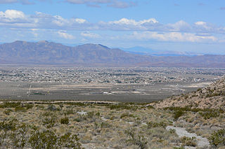
The Amargosa Desert is located in Nye County in western Nevada, United States, along the California–Nevada border, comprising the northeastern portion of the geographic Amargosa Valley, north of the Ash Meadows National Wildlife Refuge.

Mount Langley is a mountain located on the crest of the Sierra Nevada, on the boundary between Inyo and Tulare counties in eastern California, in the United States. To the east is the Owens Valley, and to the west is the Kern River Valley. It is the ninth-highest peak in the state and the seventh-highest in the Sierra. Mount Whitney, the highest peak in the contiguous United States, lies 4.8 miles (7.7 km) to the northwest. Mount Langley also has the distinction of being the southernmost fourteener in the United States.

Mount Tallac is a mountain peak southwest of Lake Tahoe, in El Dorado County, California. The peak lies within the Desolation Wilderness in the Eldorado National Forest. It is quite visible from State Routes 89 and 28, and U.S. Route 50. A "cross of snow" is clearly visible on the mountain's face during the winter, spring, and early summer months.

Leavitt Peak is located in the Emigrant Wilderness near Sonora Pass in the eastern Sierra Nevada range of California. Leavitt Peak is located on the Tuolumne County - Mono County line. The Pacific Crest Trail runs close to the east of Leavitt Peak, at an elevation of about 10,800 feet (3,290 m) elevation. The peak offers views south to Yosemite National Park and north towards South Lake Tahoe.
French Lake, California located in Nevada County, was a California Gold Rush community, now uninhabited. It was located by a lake of the same name.

Martis is the name given by scientists to the group of Native Americans who lived in Northern California on both the eastern and western sides of the Sierra Nevada. The Martis complex lasted from 2000 BCE to 500 CE, during the Middle Archaic era. Evidence of Martis habitation has been found from Carson River and Reno, Nevada in the east to Auburn, California and Oroville, California in the west. The Martis name refers to the geographic region of Martis Creek which spans Nevada County, California and Placer County, California.
Hiram Leavitt (1824–1901) was an early settler, innkeeper, and judge in Mono County, California, in the eastern Sierra Nevada. Leavitt left his mark in the area and is the namesake of features such as Leavitt Peak, Leavitt Meadow, Leavitt Creek and Leavitt Lake.
The Diamond Mountains is a mountain range in Lassen and Plumas counties, California, one of the northeasternmost portions of the Sierra Nevada.

Cirsium scariosum is a species of thistle known by the common names meadow thistle, elk thistle and dwarf thistle. It is native to much of western North America from Alberta and British Columbia, south to Baja California. There are also isolated populations on the Canadian Atlantic Coast, on the Mingan Archipelago in Québec, where it is called the Mingan thistle.
Jonesville is an unincorporated community in Butte County, California. It is situated on Jones Creek, 5 miles (8.0 km) east-northeast of Butte Meadows, at an elevation of 5049 feet.
Baltimore Town, previously Wightman’s Camp, was a historic gold mining camp in eastern Nevada County, California that was founded in 1865. After gold mining stopped in the area, the town faded away around 1869.
Bridgeport is a former settlement on the Yuba River in Nevada County, California, 2 mi (3.2 km) from the town of French Corral. Its elevation is 567 ft (173 m) above sea level.
Glenbrook is a former settlement in Nevada County, California, located near Grass Valley. It was listed on an official map as of 1949.
Sunset View is a former settlement in Nevada County, California, located near Grass Valley. It was listed on an official map as of 1949.
Pahrump Valley is a Mojave Desert valley west of Las Vegas and the Spring Mountains massif in southern Nye County, Nevada, and eastern San Bernardino County, California. Pahrump, Nevada, is in the valley's center and the Tecopa and Chicago Valleys are immediately to the west. The valley has routes to Death Valley and a route to Las Vegas. Pahrump Valley Days is the annual event in February each year, along with the sanctioned JRH-HS Rodeo.

Meadow Lake was a historic mining town in Nevada County, California. It was located on the southwest shore of Meadow Lake, about 18 miles northwest of Truckee as the crow flies. Situated at an elevation of 7,290 ft (2,220 m) above sea level, the reservoir of the same name is one of the highest lakes in elevation within the Tahoe National Forest.

Leavitt Falls is a 200-foot (61 m), multi-tiered waterfall in the Sierra Nevada of Mono County, California. The falls are located on Leavitt Creek, a tributary of the West Walker River, and are formed where the creek drops off the edge of a hanging valley into Leavitt Meadow.
Ash Meadows Sky Ranch was a brothel in Nevada near the ghost town of Shoshone, California. The procurer Vickie Starr said of the establishment “We were six prostitutes in the middle of the desert, isolated from the rest of the world, screwing horny and frustrated men for money. That was our life and as far as we were concerned it was as normal as Rice Krispies.

