
Juab County is a county in western Utah, United States. As of the 2010 United States Census, the population was 10,246. Its county seat and largest city is Nephi.

McDermitt is an unincorporated community straddling the Nevada–Oregon border, in Humboldt County, Nevada, and Malheur County, Oregon, United States. McDermitt's economy has historically been based on mining, ranching, and farming. The last mining operation closed in 1990, resulting in a steady decline in population.
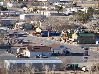
Beatty is an unincorporated town along the Amargosa River in Nye County in the U.S. state of Nevada. U.S. Route 95 runs through the town, which lies between Tonopah, about 90 miles (140 km) to the north and Las Vegas, about 120 miles (190 km) to the southeast. State Route 374 connects Beatty to Death Valley National Park, about 8 miles (13 km) to the west.

The Ansel Adams Wilderness is a wilderness area in the Sierra Nevada of California, United States. The wilderness spans 231,533 acres (93,698 ha): 33.9% of which is in the Inyo National Forest, 65.8% is in the Sierra National Forest, and the remaining 0.3% covers nearly all of Devils Postpile National Monument. Yosemite National Park lies to the north and northwest, while the John Muir Wilderness lies to the south.

Jarbidge is an unincorporated community in Elko County, Nevada, United States. Located at the bottom of the Jarbidge River's canyon near the north end of the Jarbidge Mountains, it lies within the Jarbidge Ranger District of the Humboldt-Toiyabe National Forest and is near the northwest edge of the Jarbidge Wilderness, approximately 10 miles (16 km) south of the Idaho–Nevada border. The ZIP code for Jarbidge is 89826.

The Toiyabe Range is a mountain range in Lander and Nye counties, Nevada, United States. Most of the range is included within the Humboldt-Toiyabe National Forest. The highest point in the range, near its southern end, is Arc Dome, an area protected as the Arc Dome Wilderness. The highest point in Lander County, Bunker Hill, is also located within the Toiyabe Range. The range starts in northwestern Nye County north of Tonopah, Nevada and runs approximately 120 miles (190 km) north-northeast into southern Lander County, making it the second longest range in the state.

Lake Avenue is a major north–south feeder road for the Pasadena and Altadena communities in Los Angeles County, California. The road was developed in the mid 19th century and takes its name from a lake which was located at its southernmost end known variously as Mission Lake, Kewen Lake, and Wilson Lake reflecting different owners of the land. The lake bed still exists as a municipal park in the City of San Marino just south of the Raymond Dike, but it holds no water. It has been surrounded by residences who are served by a crisscross set of roads that dip into the edges of impression and back out the other side. Lake Avenue is approximately 5.06 miles (8.14 km) in length.

Eldorado National Forest is a U.S. National Forest located in the central Sierra Nevada mountain range, in eastern California.
U.S. Route 50 (US 50) is a transcontinental highway in the United States, stretching from West Sacramento, California, in the west to Ocean City, Maryland, on the east coast. The Nevada portion crosses the center of the state and was named "The Loneliest Road in America" by Life magazine in July 1986. The name was intended as a pejorative, but Nevada officials seized it as a marketing slogan. The name originates from large desolate areas traversed by the route, with few or no signs of civilization. The highway crosses several large desert valleys separated by numerous mountain ranges towering over the valley floors, in what is known as the Basin and Range province of the Great Basin.

Ludlow is an unincorporated community in the Mojave Desert on Interstate 40, located in San Bernardino County, California, United States. The older remains of the ghost town are along historic Route 66.

Leadfield was an unincorporated community, and historic mining town in Inyo County, California. It is now a ghost town. It is located in Titus Canyon in the Grapevine Mountains, east of Death Valley in Death Valley National Park. Leadfield lies at an elevation of 4,058 ft (1,237 m). It is on the National Register of Historic Places.

The Table Mountain Wilderness is a protected wilderness area in the Monitor Range of Nye County in central section of the state of Nevada. It is the third largest wilderness area in the state. The nearest city is Tonopah, Nevada. The Table Mountain Wilderness Area covers 92,600 acres (37,500 ha), and is administered by the Humboldt-Toiyabe National Forest. The 1860s ghost town of Belmont is nearby.

Inskip is a ghost town in Butte County, California. It lies at an elevation of 4,777 feet in the northern Sierra Nevada near Lassen National Forest. The main surviving building is the Inskip Hotel, which is listed on the National Register of Historic Places.
You Bet is a small unincorporated community in Nevada County, California. You Bet is located in the Sierra Nevada foothills, 7 miles (11.3 km) east of Grass Valley and 5.5 miles (8.9 km) northeast of Chicago Park.

Havilah is an unincorporated community in Kern County, California. It is located in the mountains between Walker Basin and the Kern River Valley, 5 miles (8.0 km) south-southwest of Bodfish at an elevation of 3,136 feet (956 m).
Plumas-Eureka State Park is a California state park located in the Sierra Nevada and Cascade Range in Plumas County, California.
Snow Tent was a historic settlement in Nevada County located on the San Juan Ridge roughly midway between North Bloomfield and Graniteville, about 16 miles northeast of Nevada City, as the crow flies. It was situated around the intersection of what are now Snow Tent Road and the N. Bloomfield-Graniteville Road. It flourished in the second half of the 19th century as a center for mining and lumbering and as an important stop on one of the routes through the Henness Pass. It still appeared on maps as of 1902.

Blue Tent is a historic 19th century gold mining community located about six miles northeast of Nevada City, California.
Democrat, originally Democrat Hill, is a former settlement in Nevada County, California. It lay on the Chalk Bluff ridge, about 1 mile south of what is now Highway 20, about 6 miles southeast of the town of Washington and about 1 mile east of Remington Hill. Its elevation was 4170 feet. It lay on a gold bearing gravel channel on the Chalk Bluff Ridge, which lies between Steephollow and Greenhorn Creeks, tributaries of the Bear River. As the channel runs southwest, it joins a major channel running from the San Juan Ridge easterly through Red Dog and You Bet into Placer County.
Wolf Creek is a waterway in Nevada County, California, US. The creek is 25 miles (40 km) long. The watershed, approximately 78 square miles (200 km2), is heavily mined. Most of the creek is situated in the lower montane zone. Its altitude ranges between 3,000 feet (910 m) to 1,200 feet (370 m). Vegetation in the valley varies from alpine pines at higher elevations, to blue pines at mid elevations, and ponderosa pine mixed with evergreen forests at lower elevations. From 1850 to 1950 gold was mined in the rich formations of the Mother Lode in the heart of Banner Mountain.


