Related Research Articles

Nevada County is a county located in the U.S. state of California, in the Sierra Nevada. As of the 2020 census, its population was 102,241. The county seat is Nevada City. Nevada County comprises the Truckee-Grass Valley micropolitan statistical area, which is also included in the Sacramento-Roseville combined statistical area, part of the Mother Lode Country.

Palmdale Regional Airport is an airport in Palmdale, California, United States. The city of Palmdale took over the airport at the end of 2013, managing it via the Palmdale Airport Authority. The airport currently does not have any scheduled passenger airline service.

Troutdale Airport, also known as Troutdale-Portland Airport, is a corporate, general aviation, and flight-training airport serving the city of Troutdale, in Multnomah County, Oregon, United States. It is one of three airports in the Portland metropolitan area owned and operated by the Port of Portland. Troutdale Airport was established in 1920 as a private airfield, then purchased by the Port of Portland in 1942. It serves as a reliever airport for nearby Portland International Airport (PDX).
Charles Vincent Litton Sr. (1904–1972) was an engineer and inventor from the area now known as Silicon Valley.

Grand Canyon National Park Airport is a state-owned public-use airport located in Tusayan, CDP in unincorporated Coconino County, Arizona, United States. It is near Grand Canyon National Park, 1 mile from the South Rim entrance of the Grand Canyon. The airport is primarily used for scenic tours and charter flights.

West Michigan Regional Airport, formerly Tulip City Airport, is a public-use airport located two nautical miles (3.7 km) south of the central business district of Holland, a city in Ottawa County and Allegan County, Michigan, United States. It is included in the Federal Aviation Administration (FAA) National Plan of Integrated Airport Systems for 2017–2021, in which it is categorized as a national general aviation facility.

The Pompano Beach Airpark is a public airport located one mile (1.6 km) northeast of the central business district of Pompano Beach, in Broward County, Florida, United States. The airport is publicly owned by the City of Pompano Beach.

Charlevoix Municipal Airport is a city-owned, public-use airport located one nautical mile (2 km) southwest of the central business district of Charlevoix, a city in Charlevoix County, Michigan, United States. It is mostly used for general aviation, but also offers passenger service to Beaver Island via Island Airways and Fresh Air Aviation.

Flying Cloud Airport is a public airport located in the city of Eden Prairie in Hennepin County, Minnesota, United States, about 11 miles (18 km) southwest of the central business district (CBD) of Minneapolis.

Henderson Executive Airport is a public use government airport located in Henderson, Nevada, 13 miles south of Las Vegas, in Clark County, Nevada. The airport is owned by the Clark County Commission and operated by the Clark County Department of Aviation. The FAA's National Plan of Integrated Airport Systems for 2009-2013 categorized it as a reliever airport.

Apple Valley Airport is a public airport three miles (4.8 km) north of Apple Valley in San Bernardino County, California, United States. The airport has two runways and is used for general aviation. It opened around 1970.

Felts Field is a public airport in the Northwestern United States, located five miles (8 km) northeast of Downtown Spokane, in Spokane County, Washington. It is owned by Spokane City-County.
Bend Municipal Airport is six miles (9.7 km) northeast of Bend, in Deschutes County, Oregon. The FAA's National Plan of Integrated Airport Systems for 2009–2013 categorizes it as a general aviation facility. Bend is home to Epic Aircraft and X-Air.
Destin Executive Airport, also known as Coleman Kelly Field, is a public use airport owned by and located in Okaloosa County, Florida. The airport is one nautical mile (2 km) east of the central business district of Destin, Florida. It is included in the National Plan of Integrated Airport Systems for 2021–2025, which categorized it as a general aviation facility.

New Smyrna Beach Municipal Airport, also known as Jack Bolt Field, is a public airport located three miles (5 km) northwest of the central business district of New Smyrna Beach, a city in Volusia County, Florida, United States. It is owned by the City of New Smyrna Beach.
Clearwater Air Park is a city-owned public-use airport located three miles (4.8 km) northeast of the central business district of Clearwater, a city in Pinellas County, Florida, United States. As of March 1, 2023, The airpark is managed by FlyUSA Inc.

Beaver County Airport or is a county-owned public airport three miles northwest of Beaver Falls, in Beaver County, Pennsylvania.

Tampa Executive Airport, formerly known as Vandenberg Airport, is located in unincorporated Hillsborough County, Florida, six nautical miles east of the central business district of Tampa. VDF covers 411 acres of land.
Amedee Army Airfield is a military use airport located nine nautical miles (17 km) north of the central business district of Herlong, in Lassen County, California, United States. It is owned by the United States Army and located at the Sierra Army Depot in the Honey Lake Valley, east of the Sierra Nevada mountain range.
Jack Barstow Airport, also known as Jack Barstow Municipal Airport, is a city-owned, public-use airport located three nautical miles (6 km) northwest of the central business district of Midland, a city in Midland County, Michigan, United States. It is included in the Federal Aviation Administration (FAA) National Plan of Integrated Airport Systems for 2017–2021, in which it is categorized as a local general aviation facility.
References
- 1 2 3 4 FAA Airport Form 5010 for GOO PDF , effective June 13, 2024.
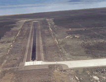
- 1 2 Nevada County Airport page at Nevada County Web site
- ↑ Great Circle Mapper: KGOO - Grass Valley, California - Nevada County Air Park
- ↑ Aviation Safety Network: GOO / YDGI - Goondiwindi Airport, QLD, Australia
- 1 2 McKinney, Gage (2016). MacBoyle's Gold. Santa Rosa: Comstock Bonanza Press. pp. 197–199. ISBN 9780933994614.
- ↑ Clark, Jack (2005). Gold in Quartz: The Legendary Idaho Maryland Mine. Grass Valley: Comstock Bonanza Press. pp. 195–197. ISBN 0933994311.