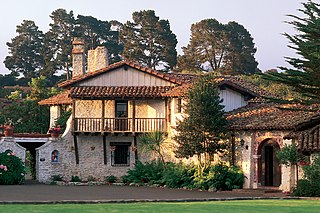
Founded on June 3, 1770, Monterey was the capital of Alta California under both Spain and Mexico until 1850. Monterey hosted California's first theater, public building, public library, publicly funded school, printing press, and newspaper. Monterey was the only port of entry for taxable goods in California. In 1846, the U.S. flag was raised over the Customs House, and California became part of the United States after the Mexican–American War.

Vallejo is a waterfront city in Solano County, California, located in the North Bay subregion of the San Francisco Bay Area. Vallejo is geographically the closest North Bay city to the inner East Bay, so it is sometimes mistakenly associated with that region. Although, the website craigslist has categorized Vallejo as part of the East Bay, a likely contributor in this dispute. Its population was 115,942 at the 2010 census. It is the tenth most populous city in the San Francisco Bay Area, and the largest in Solano County. Vallejo sits on the northeastern shore of San Pablo Bay, 30 miles north of San Francisco, the northwestern shore of the Carquinez Strait and the southern end of the Napa River, 15 miles south of Napa. The city is named after General Mariano Guadalupe Vallejo, a native Californio, leading proponent of California's statehood, and one of the first members of the California State Senate; the neighboring city of Benicia is named for his wife, Francisca Benicia Carrillo de Vallejo.
Colusa is the county seat of Colusa County, California. The population was 5,971 at the 2010 census, up from 5,402 at the 2000 census. Colusi originates from the local Coru Native American tribe, who in the 1840s lived on the opposite side of the Sacramento River.
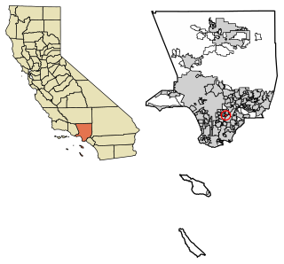
Bell Gardens is a city in Los Angeles County, California. The population was 42,072 at the 2010 census, down from 44,054 at the 2000 census.

East Blythe is a former census-designated place (CDP) and unincorporated community in Riverside County, California, United States. The 2000 census population was three.

California is a city in Moniteau County, Missouri, United States. The 2010 census has the population at 4,278. It is the county seat of Moniteau County. California is the third largest city in the Jefferson City, Missouri Metropolitan Statistical Area, as well as the largest city in Moniteau County.
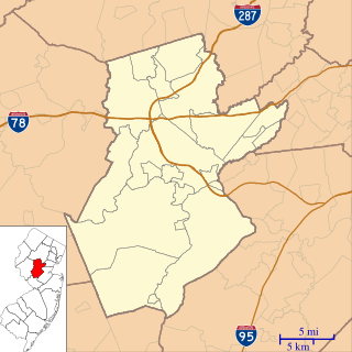
Six Mile Run is an unincorporated community and census-designated place (CDP) located in Franklin Township, in Somerset County, New Jersey, United States. As of the 2010 United States Census, the CDP's population was 3,184.

Pinedale is a previously unincorporated community in Fresno County, California. It lies at an elevation of 348 feet. It was once a rural community located on the Southern Pacific Railroad 3.5 miles (5.6 km) north-northwest of Clovis but has since become surrounded and annexed by the city of Fresno. Millerton Lake State Recreational Area is to its NE. The ZIP Code is 93650, and the community is inside area code 559.
Hamilton is a former settlement in Butte County, California, United States, and was its first permanent county seat. It was located on the west side of the Feather River, 15 miles (24 km) downstream from Oroville.

Ivanpah was a short-lived silver mining town located in San Bernardino County, California, United States. It was founded in 1869 and existed until at least the mid-1880s.

Julia Pfeiffer Burns State Park is a state park in California, 12 miles south of Pfeiffer Big Sur State Park on California's Pacific coast. A main feature of the park is McWay Falls, which drops over a cliff of 80 feet (24 m) into the Pacific Ocean. The park is also home to 300-foot (90 m) redwoods which are over 2,500 years old. The park is named after Julia Pfeiffer Burns, a respected resident and rancher in the Big Sur region in the early 20th century, who lived in the area for much of her life until her death in 1928. The 3,762-acre (1,522 ha) park was established in 1962.
Pacific is a small unincorporated community in El Dorado County, California. It is located 3.25 miles (5 km) east of Pollock Pines, at an elevation of 3396 feet. It lies along U.S. Highway 50 and is next to the town of Pacific House, California. The ZIP code is 95726. The community is inside area code 530.
Oregon House is an unincorporated community in Yuba County, California. It is located 22 miles (35 km) northeast of Marysville, at an elevation of 1526 feet.
Albeeville is a former settlement in Klamath County, now located in Humboldt County, California. Albeeville was located on Redwood Creek, within an easy day's travel from Fort Gaston. The post office was named for Joseph Porter Albee, its first postmaster, who was murdered by Indians, and the Albeeville post office burned in November 1863.
Halfway House is an unincorporated community in Kern County, California. It is located 2 miles (3.2 km) north-northwest of Knob Hill, at an elevation of 1,119 feet (341 m).
18 Mile House is a former settlement in Kern County, California. It was located just south of Cinco.
North Fork House is a former settlement in Mendocino County, California. It was located 1 mile (1.6 km) west of Navarro.
Junction House is an unincorporated community in Nevada County, California. It lies at an elevation of 4363 feet. Junction House is located 3 miles (4.8 km) south-southwest of Washington.
Brighton House is a former settlement in Nevada County, California. Brighton House is located 1 mile (1.6 km) southwest of Grass Valley. It still appeared on maps in 1901.
The MTV Malibu beach house was the setting of a number of summer programming productions by the MTV Television Network during the 1990s. The actual house is a beach house located on Pacific Coast Highway in Malibu, California, United States of America.


