Keyesville is an unincorporated community in Kern County, California. It is located 2 miles (3.2 km) west of Lake Isabella and the Kern River Valley, at an elevation of 2,848 feet (868 m). Keyesville, founded in 1854 is named for Richard M. Keyes, whose discovery of gold in 1853 started the Kern River Gold Rush.

Dog Town is a gold rush era ghost town in Mono County, California. It is located at 38°10′13″N119°11′51″W, on Dog Creek, near the junction of Clearwater and Virginia Creeks, about 6 miles (10 km) south-southeast of Bridgeport, at an elevation of 7057 feet.
Bidwell's Bar was a gold mining camp in Butte County, California, United States, which lay at the end of the California Trail. It was located 6.5 miles (10.5 km) east-northeast of Oroville, at an elevation of 902 feet.
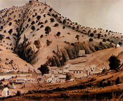
Carson Hill is a ghost town in Calaveras County, California. It sits at an elevation of 1447 feet above sea level and is located at 38°01′42″N120°30′24″W, about 4 miles (6.4 km) south-southeast of Angels Camp. It was one of the most productive mining camps in the state, with nearly $26 million in gold and quartz found in the area. Carson Hill is registered as California Historical Landmark #274. The town was served by the Sierra Railway's branchline to Angels Camp until 1935.

Garlock is an unincorporated community in Kern County, California. It is located 6.25 miles (10 km) east-southeast of Saltdale, at an elevation of 2169 feet.

El Dorado is an unincorporated community in El Dorado County, California. It is located 4 miles (6.4 km) southwest of Placerville, at an elevation of 1608 feet. The population was 4,096 at the 2000 census. The town is registered as California Historical Landmark #486. The ZIP code is 95623. The community is inside area code 530.
Agua Fria is an unincorporated community in Mariposa County, California. It is located 5.25 miles (8.4 km) northeast of Catheys Valley, at an elevation of 2001 feet. Agua Fria is the former county seat of Mariposa County located approximately three miles west of Mariposa, California.
You Bet is a small unincorporated community in Nevada County, California. You Bet is located in the Sierra Nevada foothills, 7 miles (11.3 km) east of Grass Valley and 5.5 miles (8.9 km) northeast of Chicago Park.

Mormon Bar is an unincorporated community in Mariposa County, California. It is located 2 miles (3.2 km) south-southeast of Mariposa, at an elevation of 1772 feet. Mormon Bar is located near State Route 49.
Ophir is an unincorporated community in Placer County, California.
French Corral is an unincorporated community approximately five miles west of California State Highway 49 in Nevada County, California.

Havilah is an unincorporated community in Kern County, California. It is located in the mountains between Walker Basin and the Kern River Valley, 5 miles (8.0 km) south-southwest of Bodfish at an elevation of 3,136 feet (956 m).
Condemned Bar is a former settlement, in Yuba County, California. It lay at the confluence of Dobbins Creek and the Yuba River, 3 miles (4.8 km) south-southeast of Dobbins, It is in the Sierra Nevada foothills, at an elevation of 548 feet.
Bridgeport is a former settlement on the Yuba River in Nevada County, California, 2 mi (3.2 km) from the town of French Corral. Its elevation is 567 ft (173 m) above sea level.
Cherokee is a former gold mining community in Nevada County, California. As explained below, it has also been known as Patterson, Melrose and Tyler. It is located on the San Juan Ridge about 4 miles east of North San Juan. Its elevation is 2,516 ft (767 m) above sea level.
Red Dog was a California gold rush mining town located in the Gold Country in south-central Nevada County, California, United States, 6 mi (9.7 km) northeast of Chicago Park. Red Dog Hill, a mine and campsite, was founded by three men all under the age of 22, and was named by their youngest, a 15-year-old prospector. As mining operations grew, the campsite became a settlement, and then a town with a population of 2,000 residents, before it was eventually abandoned. Still considered important today, Red Dog Townsite is listed on the National Register of Historic Places.

Gold Run was a former mining town of the California Gold Rush, located in Placer County, California.

Iowa Hill is an unincorporated community in Placer County, California, United States. The town is located 6.5 miles northwest of Foresthill 9 miles east of Colfax and 58 miles northeast of Sacramento. It lies at an elevation of 2861 feet. The community relies completely upon solar panels and generators for power. Its population is around 200 people. Iowa Hill Road claims a small handful of lives every decade, and along with the community's "off grid" status, prevents the town from growing in population. The community boasts many hardcore cyclists and is appealing to visitors due to the abundance of recreational opportunities.

Michigan Bluff is an unincorporated community in Placer County, California. Michigan Bluff is 4.35 miles (7.0 km) east-northeast of Foresthill. It is at an elevation of 3,510 feet (1,070 m).
Middle Bar is a former mining town on the Mokelumne River in Amador County, California. It is a California Historical Landmark.


