
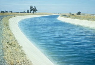
The Governor Edmund G. Brown California Aqueduct is a system of canals, tunnels, and pipelines that conveys water collected from the Sierra Nevada Mountains and valleys of Northern and Central California to Southern California. Named after California Governor Edmund Gerald "Pat" Brown Sr., the over 400-mile (640 km) aqueduct is the principal feature of the California State Water Project.
The Delta–Mendota Canal is a 117 mi (188 km) aqueduct in central California, United States. It is part of the Central Valley Project and its purpose is to replace water in the San Joaquin River that is diverted into Madera Canal and Friant-Kern Canal at Friant Dam. Average annual throughput is 1,993,000 acre feet (2.458 km3).

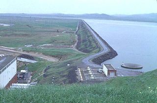
The San Luis Reservoir is an artificial lake on San Luis Creek in the eastern slopes of the Diablo Range of Merced County, California, approximately 12 mi (19 km) west of Los Banos on State Route 152, which crosses Pacheco Pass and runs along its north shore. It is the fifth largest reservoir in California. The reservoir stores water taken from the San Joaquin-Sacramento River Delta. Water is pumped uphill into the reservoir from the O'Neill Forebay which is fed by the California Aqueduct and is released back into the forebay to continue downstream along the aqueduct as needed for farm irrigation and other uses. Depending on water levels, the reservoir is approximately nine miles long from north to south at its longest point, and five miles (8 km) wide. At the eastern end of the reservoir is the San Luis Dam, or the B.F. Sisk Dam, the fourth largest embankment dam in the United States, which allows for a total capacity of 2,041,000 acre feet (2,518,000 dam3).

Santa Nella is a census-designated place in Merced County, California. It is located 11 miles (18 km) east-northeast of Pacheco Pass, at an elevation of 154 feet, At the 2010 census, Santa Nella had a population of 1,380 people.

Castaic Lake is a reservoir formed by Castaic Dam on Castaic Creek, in the Sierra Pelona Mountains of northwestern Los Angeles County, California, United States, near the town of Castaic.
The North Bay Aqueduct (NBA) is part of the California State Water Project. The aqueduct is 27.4 miles (44.1 km) long all in pipelines and serves Napa and Solano counties, California.
The Harvey O. Banks Pumping Plant is located 2.5 miles (4 km) southwest of the Clifton Court Forebay and 12 miles (19 km) northwest of Tracy, CA. The plant is the first pumping plant for the California Aqueduct and the South Bay Aqueduct. It provides the necessary fluid head for the California Aqueduct to flow for approximately 80 miles (130 km) south past the O'Neill Forebay and the San Luis Reservoir to the Dos Amigos Pumping Plant. The Banks Pumping Plant initially flows into the Bethany Reservoir. It is from the Bethany Reservoir that the South Bay Aqueduct begins.

The Bethany Reservoir is located 8 miles (13 km) northeast of Livermore, California, USA, on the California Aqueduct. It serves as the forebay for the South Bay Pumping Plant that feeds the South Bay Aqueduct.

Silverwood Lake is a large reservoir in San Bernardino County, California, United States, located on the West Fork Mojave River, a tributary of the Mojave River in the San Bernardino Mountains. It was created in 1971 as part of the State Water Project by the construction of the Cedar Springs Dam as a forebay on the 444-mile (715 km) long California Aqueduct, and has a capacity of 73,000 acre feet (90,000,000 m3).
Clifton Court Forebay is a reservoir in the San Joaquin River Delta region of eastern Contra Costa County, California, 17 mi (27 km) southwest of Stockton. The estuary region the forebay is located in is only 1m to 3m above mean sea level.

The Oroville–Thermalito Complex is a group of reservoirs, structures, and facilities located in and around the city of Oroville in Butte County, California. The complex serves not only as a regional water conveyance and storage system, but is the headwaters for, and therefore perhaps is the most vital part of, the California Department of Water Resources' State Water Project, the world's largest publicly built and operated water and power development and conveyance system.
O'Neill Forebay is a forebay to the San Luis Reservoir created by the construction of O'Neill Dam across San Luis Creek approximately 12 miles (19 km) west of Los Banos, California, United States, on the eastern slopes of the Pacific Coast Ranges of Merced County.
O'Neill Dam is an earthfill dam on San Luis Creek, 12 miles (19 km) west of Los Banos, California, United States, on the eastern slopes of the Pacific Coast Ranges of Merced County. Forming the O'Neill Forebay, a forebay to the San Luis Reservoir, it is roughly 2.5 miles (4.0 km) downstream from the San Luis Dam.
Kings Island is an island in the Old River (California) in the south Sacramento-San Joaquin River Delta in San Joaquin County, California, fifteen kilometres southwest of Stockton. The small 3.5 ha (8.6-acre) island is the smallest of a cluster of delta islands including Eucalyptus Island, Widdows Island, Victoria Island (California), and Coney Island, adjacent to Clifton Court Forebay. At 1 metre below sea level with the surrounding waters kept a bay by a levee system, the island is accessible only by the one road from the Clifton Court levee or by boat.
Sugarloaf is in the name of two different mountains that are located in Butte County of northern California.
San Luis Creek, originally Arroyo de San Luis Gonzaga, is a stream in Merced County, California. Its source is located in Merced County, about 1,000 ft (300 m) northwest of the 3,448 ft (1,051 m) Mariposa Peak, on the Merced County - San Benito County boundary and 7.4 mi (11.9 km) south of Pacheco Pass. Its mouth is at its confluence with Los Banos Creek, 3.6 mi (5.8 km) east of Ingomar, California.
Elderberry Forebay is a small reservoir in Los Angeles County, California, which serves as the pumping forebay of the Castaic Power Plant. It located at the upper end of the larger Castaic Lake and is separated from the lake by Elderberry Forebay Dam at its southern edge. Entering the northern end of the forebay is the west branch of the California Aqueduct, which connects the forebay to Pyramid Lake through the Angeles Tunnel.
Elderberry Forebay Dam is a dam located in the Sierra Pelona Mountains of northwestern Los Angeles County, California.

The Angeles Tunnel is a 7.2-mile-long (11.6 km), 30-foot-diameter (9.1 m) water tunnel located in the Sierra Pelona Mountains in Los Angeles County, California, about 50 miles (80 km) north of Los Angeles. It was constructed between 1967 and 1970 as part of the California State Water Project and serves as the final leg of the west branch of the California Aqueduct, which carries Northern California water to Southern California residents.


