
Sierra County is a county in the U.S. state of California. As of the 2010 census, the population was 3,240 making it California's second-least populous county. The county seat is Downieville, and the only incorporated city is Loyalton. The county is in the Sierra Nevada, northeast of Sacramento on the border with Nevada.

Yuba County is a county in the U.S. state of California. As of the 2010 U.S. Census, the population was 72,155. The county seat is Marysville. Yuba County is included in the Yuba City, California Metropolitan Statistical Area, which is also included in the Sacramento–Roseville, California Combined Statistical Area. The county is located in the state's Central Valley region along the Feather River.

Rocklin is a city in Placer County, California located approximately 22 miles (35 km) from Sacramento, California, and about 6.1 miles (9.8 km) northeast of Roseville in the Sacramento metropolitan area. Besides Roseville, it shares borders with Granite Bay, Loomis and Lincoln. As of the 2010 census, Rocklin's population was 56,974.

The city of Chicago is located in northern Illinois, United States, at the south western tip of Lake Michigan. It sits on the Saint Lawrence Seaway continental divide at the site of the Chicago Portage, an ancient trade route connecting the Mississippi River and the Great Lakes watersheds.

Sierra College, a California community college, has its main campus in Rocklin, California, United States. Rocklin is in the foothills of the Sierra Nevada Mountains, approximately 20 minutes from the state capital of Sacramento and 105 miles (169 km) east of San Francisco. The campus lies within the watershed of Secret Ravine, a site of mining operations during the California Gold Rush. In addition to the 300-acre (1.2 km2) Rocklin campus, the District has a 115-acre (0.47 km2) campus in Grass Valley which is in neighboring Nevada County, a campus center in Truckee, and a campus center in Roseville. The Sierra Community College District, a district that covers over 3,200 square miles (8,300 km2), serves Placer, Nevada and parts of El Dorado and Sacramento counties.

Chavez Ravine is a shallow L-shaped canyon located in Los Angeles, California, United States, partially in the Elysian Park neighborhood. It sits in a large promontory of hills north of downtown Los Angeles and was known in the 1860s as the "Stone Quarry Hills" which had other smaller ravines such as Sulphur Ravine, Cemetery Ravine, Solano Canyon and Reservoir Ravine. It is next to Dodger Stadium, a baseball venue that opened in 1962. The name Chavez Ravine can be used to mean either the actual ravine itself in a narrow sense or sometimes in a broader sense the entire promontory and surrounding ravines, and is also used to refer to the stadium. Dodger Stadium was constructed by knocking down the ridge which separated the nearby Sulfur and Cemetery Ravines and filling those two ravines in. Palo Verde Elementary School was buried in the process. Chavez Ravine was named for Julian Chavez, a Los Angeles councilman in the 19th century. Chavez originally purchased the land in the Elysian Park area, which eventually grew to about 315 acres, in 1844. Nearby "Cemetery Ravine" was named after old Calvary, the first cemetery of Los Angeles.
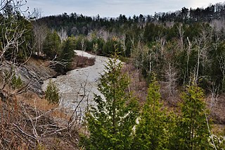
Dry Creek is a 15-mile (24 km) long stream in Placer County, California, tributary to the Sacramento River. Its watershed lies within the Sacramento Valley. Because suburban development borders much of its length, the stream is noted for its capacity to cause local flooding and as a recreational attraction.
The Toronto ravine system is one of the most distinctive features of the geography of Toronto, Ontario, Canada. It is a network of deep ravines that form a large urban forest that runs throughout much of the city. For the most part designated as parkland, the ravines are largely undeveloped. Toronto's slogan: "The city within a park" partially stems from the extensive ravine green space.

Frenches Ravine is a former settlement in Yuba County, California. It was located 3.5 miles (5.6 km) south-southeast of Dobbins, at an elevation of 531 feet. It still appeared on maps as of 1895.
Hawk Ravine is a former settlement in Butte County, California. It lay at an elevation of 1266 feet. It still appeared on maps as of 1897.

Smithflat is an unincorporated community in El Dorado County, California, USA. It lies 4 km (2.5 mi) east of Placerville and 7.2 km (4.5 mi) west of Camino at an elevation of 2224 feet.
Boston Ravine is a former settlement in Nevada County, California. Boston Ravine is located 1 mile (1.6 km) south-southwest of Grass Valley. Its elevation is 2,339 ft (713 m) above sea level.
Pleasant Flat is a former settlement in Nevada County, California. Pleasant Flat is located on Deer Creek, 1 mile (1.6 km) east-southeast of Newtown. It still appeared on maps as of 1873.
Stockings Flat is a former settlement in Nevada County, California. Stockings Flat is located on Deer Creek, 2.5 miles (4.0 km) east of Newtown. It still appeared on maps as of 1873.
Flat Ravine is a former settlement in Placer County, California. It lay at an elevation of 6056 feet. It still appeared on maps as of 1898.
Secret Ravine is a former settlement in Placer County, California. Secret Ravine is located 3 miles (4.8 km) southwest of Newcastle. Correction: Gardiner writes in 1854 that the Secret Ravine Post Office is "near the Hawes Ranch." Elisha Hawes lived in Township 9, the 1860 census shows him continuing to receive mail at the Secret Ravine Post Office. Placer County records show that Elisha Hawes and his family sold the ranch in 1867, and that it was located on Secret Ravine near the intersection of what is now I-80 and Rocklin Road, in the area commonly called China Gardens.
Virginiatown is an unincorporated community in Placer County, California. Virginiatown is located on Auburn Ravine, 7.5 miles (12.1 km) west of Auburn. It lies at an elevation of 322 feet.
Fort Trojan is a former settlement in Placer County, California. Fort Trojan is located on Auburn Ravine, 1 mile (1.6 km) down from Virginiatown.
Pine Grove is a former settlement in Placer County, California. Pine Grove is located in Secret Ravine, 1.5 miles (2.4 km) from Loomis.


