Related Research Articles

Placer County, officially the County of Placer, is a county located in the U.S. state of California. As of the 2020 census, the population was 404,739. The county seat is Auburn.
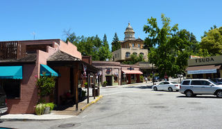
Auburn is a city in and the county seat of Placer County, California, United States. Its population was 13,776 during the 2020 census. Auburn is known for its California Gold Rush history and is registered as a California Historical Landmark.

Loomis is an incorporated town in Placer County, California, United States. It is part of the Sacramento–Arden-Arcade–Roseville Metropolitan Statistical Area. The town's population was reported as 6,836 in the 2020 United States Census. It shares borders with the city of Rocklin and the Census-Designated Places Penryn and Granite Bay.

Rocklin is a city in Placer County, California, about 22 miles (35 km) from Sacramento, and about 6.1 miles (9.8 km) northeast of Roseville in the Sacramento metropolitan area. Besides Roseville, it shares borders with Granite Bay, Loomis and Lincoln. As of the 2020 census, Rocklin's population was 71,601.

Area codes 916 and 279 are California telephone area codes that serve Sacramento, the state capital, and most of its suburbs. Area code 916 was one of the first three original area codes established in California in October 1947. It originally covered most of Northern California, but area code splits have reduced its coverage to the greater Sacramento area. Area code 279 began service in March 2018 to relieve an exhausted supply of telephone numbers in the 916 area code.
Chalone identifies the first American Viticultural Area (AVA) established in Monterey County, California straddling its border with San Benito County where it is the second established AVA. Chalone viticultural area is located in the Gabilan Mountains east of Soledad. It was recognized by the Bureau of Alcohol, Tobacco and Firearms (ATF) effective on July 14, 1982 after reviewing the petition submitted by the Gavilan Vineyards, Inc. to establish a viticultural area in Monterey and San Benito counties to be named "The Pinnacles." The area encompasses 8,640 acres (14 sq mi) and the proposed name was recognition of the nearby Chalone peaks.
California's 3rd congressional district is a U.S. congressional district in California. It includes the northern Sierra Nevada and northeastern suburbs of Sacramento, stretching south to Death Valley. It encompasses Alpine, Inyo, Mono, Nevada, Placer, Plumas, and Sierra counties, as well as parts of El Dorado, Sacramento, and Yuba counties. It includes the Sacramento suburbs of Roseville, Folsom, Orangevale, Rocklin, and Lincoln, and the mountain towns of Quincy, South Lake Tahoe, Truckee, Mammoth Lakes, and Bishop. The district is represented by Republican Kevin Kiley.
Dry Creek is a 15-mile (24 km) long stream in Placer County, California, tributary to the Sacramento River via Steelhead Creek. Its watershed lies within the Sacramento Valley. Because suburban development borders much of its length, the stream is noted for its capacity to cause local flooding and as a recreational attraction.

Sierra Foothills is a vast American Viticultural Area (AVA) encompassing the foothill "belt" of the Sierra Nevada in north-central California, United States. It was established on December 18, 1987 by the Bureau of Alcohol, Tobacco and Firearms (ATF), Treasury after evaluating the petition filed by the Sierra Foothills Winery Association of Somerset, California for the establishment of a "Sierra Foothills" viticultural area in portions of Yuba, Nevada, Placer, El Dorado, Amador, Calaveras, Tuolumne and Mariposa Counties. Wine grapes were introduced to the area in the nineteenth century during the California Gold Rush. Over 280 vineyards/wineries are located within its boundaries.

The Spring Mountain District AVA is an American Viticultural Area located in the Napa Valley AVA in California. Spring Mountain District AVA was officially established as an American Viticulture Area in 1993. Encompassed within its bounds are about 8,600 acres (3,480 ha), of which about 1,000 acres (400 ha) are planted to vineyards. Given the small crop yields on hillsides, the region represents less than 2% of Napa Valley wine. Currently the region has just over 30 winegrowers.

El Dorado is an American Viticultural Area (AVA) located in El Dorado County, California, east of the state’s capital, Sacramento and centered around the county seat of Placerville. It was established on November 14, 1983 by the Bureau of Alcohol, Tobacco, Firearms and Explosives (ATF), Treasury after approving the submitted petition from the El Dorado Wine Grape Growers Association of Camino, California applying to establish a viticultural area named "El Dorado.” The area includes parts of El Dorado County on the north border by the Middle Fork American River and on the south by the South Fork of the Cosumnes River. El Dorado viticultural area lies within the vast 4,062 square miles Sierra Foothills viticultural area, one of the largest appellations in California, which extends about 170 miles (274 km) through portions of Yuba, Nevada, Placer, El Dorado, Amador, Calaveras, Tuolumne and Mariposa Counties. The El Dorado viticultural area encompasses 1,093,120 acres (1,708 sq mi) which entirely includes Fair Play and a small portion of northeastern California Shenandoah Valley AVAs.
The Fair Play AVA is an American Viticultural Area in El Dorado County, California, United States. It is entirely contained within the boundaries of the El Dorado AVA and the Sierra Foothills AVA. The boundaries of the Fair Play AVA include rolling hills at elevations between 2,000 feet (610 m) and 3,000 feet (914 m) above sea level, making it the California appellation with the second highest average elevation after the Squaw Valley-Miramonte appellation. The soils are decomposed granite as part of the Sierra Nevada Foothills region, and the area is within the Cosumnes River watershed. The most popular red wine grape variety is Zinfandel, although varieties popular in southern Rhone Valley France and Italy, such as Syrah, Grenache, Mourvedre, Sangiovese and Barbera are quite commonly planted here. White wine is less popular in this AVA, but significant plantings of Viognier and Grenache Blanc, along with Chardonnay are the more popular white varietals.

Fiddletown is an American Viticultural Area (AVA) in Amador County, California, United States. The area was established on November 3, 1983 by the Bureau of Alcohol, Tobacco and Firearms (ATF), Treasury after reviewing the petition submitted from the Fiddletown Wine Grape Growers in Amador County to establish a viticultural area to be known as "Fiddletown." The region was first settled in 1849, during the California Gold Rush. Settlers who stayed in the area eventually planted grape vines, which became abundant by the end of the nineteenth century. Most of the vineyards in the Fiddletown AVA are located in the south and west portion of the region on Sierra Nevada slopes between 1,500 to 2,500 feet (457–762 m) above sea level. About 20% of the wine produced in Amador County comes from Fiddletown viticultural area.

California's 6th senatorial district is one of 40 California State Senate districts. It is currently represented by Republican Roger Niello of Fair Oaks.
The Auburn Journal is a newspaper based in Auburn, California. The newspaper is the flagship of Gold Country Media, a division of Brehm Communications.
Hidden Valley is a housing development in an unincorporated area of Placer County, California, adjacent to Granite Bay. Hidden Valley is located 4.25 miles (6.8 km) east-southeast of Rocklin. It lies at an elevation of 436 feet.
Secret Ravine is a former settlement in Placer County, California. Secret Ravine is located 3 miles (4.8 km) southwest of Newcastle. Correction: Gardiner writes in 1854 that the Secret Ravine Post Office is "near the Hawes Ranch." Elisha Hawes lived in Township 9, the 1860 census shows him continuing to receive mail at the Secret Ravine Post Office. Placer County records show that Elisha Hawes and his family sold the ranch in 1867, and that it was located on Secret Ravine near the intersection of what is now I-80 and Rocklin Road, in the area commonly called China Gardens.

Le Casque Winery is a winery in Loomis, California in the United States. Le Casque Winery is located within the Sierra Foothills AVA and more specifically within Placer County.
The Placer Valley is a region spanning the western slope of Placer County in Northern California and refers to the valley of Placer County. Placer Valley is located in the greater Sacramento metropolitan area. The area is 71 square miles in total.
Rocklin Cemetery is a historic public cemetery, located at 4090 Kannasto Street in Rocklin, Placer County, California.
References
- ↑ Ruhkala, Roy (1974). "History of Rocklin California: From Gold to Granite". www.rocklinhistory.org. Rocklin Historical Society. Retrieved 2021-12-07.
- ↑ postalhistory.com
- ↑ "About". Secret Ravine Vineyard and Winery. 2008-05-09. Archived from the original on 2008-05-09.
- ↑ California's Geographic Names - "Secret Ravine"