Related Research Articles

Calaveras County, officially the County of Calaveras, is a county in the northern portion of the U.S. state, California. As of the 2010 census, the population was 40,171. The county seat is San Andreas. Angels Camp is the only incorporated city in the county. Calaveras is the Spanish word for skulls; the county was reportedly named for the remains of Native Americans discovered by the Spanish explorer Captain Gabriel Moraga.
A bar association is a professional association of lawyers as generally organized in countries following the Anglo-American types of jurisprudence. The word bar is derived from the old English/European custom of using a physical railing to separate the area in which court business is done from the viewing area for the general public.

Mineral Point is a city in Iowa County, Wisconsin, United States. The city is located within the Town of Mineral Point. Mineral Point is part of the Madison Metropolitan Statistical Area. Wisconsin's third oldest city, Mineral Point was settled in 1827, becoming a lead and zinc mining center during the 19th and early 20th centuries. Today the city's historical character has made it a regional tourist destination. The population was 2,487 at the 2010 census.

Placer mining is the mining of stream bed (alluvial) deposits for minerals. This may be done by open-pit or by various surface excavating equipment or tunneling equipment.

Owens Lake is a mostly dry lake in the Owens Valley on the eastern side of the Sierra Nevada in Inyo County, California. It is about 5 miles (8.0 km) south of Lone Pine, California. Unlike most dry lakes in the Basin and Range Province that have been dry for thousands of years, Owens held significant water until 1913, when much of the Owens River was diverted into the Los Angeles Aqueduct, causing Owens Lake to desiccate by 1926. Today, some of the flow of the river has been restored, and the lake now contains some water. Nevertheless, as of 2013, it is the largest single source of dust pollution in the United States. The lake was the epicenter of a magnitude 5.8 earthquake that occurred on June 24, 2020.
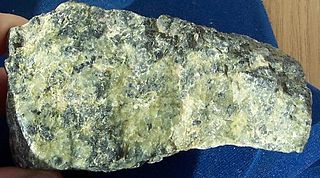
The serpentine subgroup are greenish, brownish, or spotted minerals commonly found in serpentinite rocks. They are used as a source of magnesium and asbestos, and as a decorative stone. The name is thought to come from the greenish color being that of a serpent.

The California State Mining and Mineral Museum is a museum in the state park system of California, USA, interpreting the state's mineral resources and mining heritage. It is located in Mariposa on the Mariposa County fairgrounds.
Grover Hot Springs State Park is a state park of California, USA, containing natural hot springs on the eastern side of the Sierra Nevada. Park amenities include a swimming pool complex fed by the hot springs, as well as a campground, picnic area, and hiking trails. The 553-acre (224 ha) park was established in 1959.

The State Bar of California is California's official attorney licensing agency. It is responsible for managing the admission of lawyers to the practice of law, investigating complaints of professional misconduct, prescribing appropriate discipline, accepting attorney-member fees and financially distributing sums paid through attorney trust accounts to fund non-profit legal entities. It is directly responsible to the Supreme Court of California, however, its Trustees are now appointed by the Supreme Court, the California Legislature and Governor of California. All attorney admissions and disbarments are issued as recommendations of the State Bar, which are then routinely ratified by the Supreme Court.

Castle Crags is a dramatic and well-known rock formation in Northern California. Elevations range from 2,000 feet (610 m) along the Sacramento River near the base of the crags, to over 6,500 feet (2,000 m) at the summit of the tallest crag.

Rodeo Beach is a beach in the Golden Gate National Recreation Area located in Marin County, California, United States, two miles north of the Golden Gate Bridge. It is characterized by a spit of around 50 meters width at the mouth of a long embayment, known as Rodeo Lagoon; for much of the year the lagoon is cut off from the ocean, making the beach spit a baymouth bar. Part of the beach is sheltered by cliffs. Rodeo Beach is known for its dark, pebbly sand, its uses for surfing and sunbathing, and its locale as a place for viewing, but not collecting, semi-precious stones. This beach is unique among California beaches in that it is largely made up of coarse, pebbly chert grains, both red and green in color. Its mineral composition sets it apart from every other beach in the state Surfing is possible throughout the year and at all tidal stages, but is best in summer — although there is a risk of shark attacks. Due to the North bar offshore of this beach it results in big waves in the winter months with the big swells that come in. Strong currents make swimming dangerous.

Orleans, is an unincorporated community in Humboldt County, California. It is located 12 miles (19 km) northeast of Weitchpec along State Route 96, at an elevation of 404 feet. The ZIP Code is 95556. It is within the area code 530. It is within the aboriginal territory of the Karuk Tribe of California.

Howlite, a calcium borosilicate hydroxide (Ca2B5SiO9(OH)5), is a borate mineral found in evaporite deposits.
Keller v. State Bar of California, 496 U.S. 1 (1990), was a case in which the Supreme Court of the United States held that attorneys who are required to be members of a state bar association have a First Amendment right to refrain from subsidizing the organization’s political or ideological activities.
Rogers is a former settlement in Fresno County, California. It was located near of Coalinga Mineral Springs.
Duncan Springs is an unincorporated community in Mendocino County, California. It is located 1.5 miles (2.4 km) south-southwest of Hopland, at an elevation of 781 feet.

Iowa Hill is an unincorporated community in Placer County, California, United States. The town is located 6.5 miles northwest of Foresthill 9 miles east of Colfax and 58 miles northeast of Sacramento. It lies at an elevation of 2861 feet. The community relies completely upon solar panels and generators for power. Population is around 200 people. Iowa Hill Road claims a small handful of lives every decade, and along with the community's "off grid" status, prevents the town from growing in population. The community boasts many hardcore cyclists and is appealing to visitors due to the abundance of recreational opportunities.

Montgomery Pass is a mountain pass on U.S. Route 6 in Mineral County, Nevada. The pass is near the Nevada/California border in Inyo National Forest.

B Bar H Ranch, California is an unincorporated area with cultural and historical features and is a residential community in Riverside County, California. B Bar H Ranch is located between Palm Springs and Desert Hot Springs in the Seven Palms Valley. California Home Town Locator states the B Bar H Ranch Latitude is 33.9102927 and Longitude is -116.4819566. The GNIS entry date is January 19, 1981. B Bar H Ranch sits at an elevation of 784 feet (239 m). B Bar H Ranch is approximately eight miles north of Palm Springs, California and approximately six miles south of Desert Hot Springs, California. B Bar H Ranch's approximate 240 acres are bordered by 18th Avenue to the north, Mountain View Road to the east, 20th Avenue to the south, and Bubbling Wells Road to the west. B Bar H Ranch consisted of approximately 899 residents as of the 2010 US Census.
References
- 1 2 3 Durham, David L. (1998). California's Geographic Names: A Gazetteer of Historic and Modern Names of the State. Clovis, Calif.: Word Dancer Press. p. 468. ISBN 1-884995-14-4.

| | This Placer County, California-related article is a stub. You can help Wikipedia by expanding it. |