Sheridan, Placer County, California

Last updated
Sheridan
census-designated place
USA California location map.svg
Red pog.svg
Sheridan
Position in California.
Coordinates: 38°58′47″N121°22′32″W / 38.97972°N 121.37556°W / 38.97972; -121.37556 Coordinates: 38°58′47″N121°22′32″W / 38.97972°N 121.37556°W / 38.97972; -121.37556
Country Flag of the United States.svg United States
State Flag of California.svg  California
County Flag of Placer County, California.png Placer
Area [1]
  Total 26.044 sq mi (67.455 km2)
  Land 26.038 sq mi (67.439 km2)
  Water 0.006 sq mi (0.015 km2)  0.02%
Elevation [2] 112 ft (34 m)
Population (2010)
  Total 1,238
  Density 48/sq mi (18/km2)
Time zone Pacific (PST) (UTC-8)
  Summer (DST) PDT (UTC-7)
ZIP Code 95681
Area code(s) 530
GNIS feature IDs 232964; 2583137
U.S. Geological Survey Geographic Names Information System: Sheridan, Placer County, California; U.S. Geological Survey Geographic Names Information System: Sheridan, Placer County, California

Sheridan is a census-designated place in Placer County, California, United States. [3] It is located at the western edge of the county, along State Route 65. Sheridan is 7.5 miles (12.1 km) northwest of Lincoln. [4] Its ZIP code is 95681 and area code 530. The elevation is 112 feet (34 m). The population was 1,238 at the 2010 census.

A census-designated place (CDP) is a concentration of population defined by the United States Census Bureau for statistical purposes only. CDPs have been used in each decennial census since 1980 as the counterparts of incorporated places, such as self-governing cities, towns, and villages, for the purposes of gathering and correlating statistical data. CDPs are populated areas that generally include one officially designated but currently unincorporated small community, for which the CDP is named, plus surrounding inhabited countryside of varying dimensions and, occasionally, other, smaller unincorporated communities as well. CDPs include small rural communities, colonias located along the U.S. border with Mexico, and unincorporated resort and retirement communities and their environs.

Placer County, California County in California, United States

Placer County, officially the County of Placer, is a county in the U.S. state of California. As of the 2010 census, the population was 348,432. The county seat is Auburn.

California State of the United States of America

California is a state in the Pacific Region of the United States. With 39.6 million residents, California is the most populous U.S. state and the third-largest by area. The state capital is Sacramento. The Greater Los Angeles Area and the San Francisco Bay Area are the nation's second and fifth most populous urban regions, with 18.7 million and 8.8 million residents respectively. Los Angeles is California's most populous city, and the country's second most populous, after New York. California also has the nation's most populous county, Los Angeles County, and its largest county by area, San Bernardino County. The City and County of San Francisco is both the country's second-most densely populated major city after New York and the fifth-most densely populated county, behind only four of the five New York City boroughs.

Contents

History

The Sheridan post office opened in 1868, closed for a time in 1870, and re-opened. [4]

Governance

Sheridan is governed by the Placer County Board of Supervisors. The Supervisor currently elected to the Sheridan area district is Robert Weygandt. The Sheridan area has its own Municipal Advisory Committee (Sheridan MAC) which serves as an advisory board to the County's Board of Supervisors. [5]

Geography

According to the United States Census Bureau, the CDP covers an area of 26.0 square miles (67.5 km²), 99.98% of it land, and 0.02% of it water.

United States Census Bureau bureau of the United States responsible for the census and related statistics

The United States Census Bureau is a principal agency of the U.S. Federal Statistical System, responsible for producing data about the American people and economy. The Census Bureau is part of the U.S. Department of Commerce and its director is appointed by the President of the United States.

Climate

Climate data for Lincoln, California
MonthJanFebMarAprMayJunJulAugSepOctNovDecYear
Record high °F (°C) 76
(24)
83
(28)
89
(32)
97
(36)
105
(41)
113
(45)
111
(44)
112
(44)
113
(45)
104
(40)
89
(32)
79
(26)
113
(45)
Average high °F (°C) 55
(13)
62
(17)
68
(20)
75
(24)
83
(28)
91
(33)
97
(36)
96
(36)
90
(32)
80
(27)
65
(18)
56
(13)
77
(25)
Daily mean °F (°C) 48
(9)
53
(12)
57.5
(14.2)
64.5
(18.1)
71.5
(21.9)
79
(26)
78
(26)
79.5
(26.4)
78
(26)
68
(20)
58
(14)
48
(9)
65.3
(18.6)
Average low °F (°C) 39
(4)
43
(6)
46
(8)
49
(9)
55
(13)
60
(16)
64
(18)
62
(17)
59
(15)
52
(11)
45
(7)
40
(4)
51
(11)
Record low °F (°C) 20
(−7)
23
(−5)
26
(−3)
32
(0)
38
(3)
45
(7)
45
(7)
47
(8)
43
(6)
32
(0)
27
(−3)
17
(−8)
17
(−8)
Source: http://www.weather.com/weather/wxclimatology/monthly/graph/USCA0608

Demographics

The 2010 United States Census [6] reported that Sheridan had a population of 1,238. The population density was 47.5 people per square mile (18.4/km²). The racial makeup of Sheridan was 1,026 (82.9%) White, 7 (0.6%) African American, 20 (1.6%) Native American, 13 (1.1%) Asian, 3 (0.2%) Pacific Islander, 113 (9.1%) from other races, and 56 (4.5%) from two or more races. Hispanic or Latino of any race were 253 persons (20.4%).

2010 United States Census national census of the United States taken in 2010

The 2010 United States Census is the twenty-third and most recent United States national census. National Census Day, the reference day used for the census, was April 1, 2010. The census was taken via mail-in citizen self-reporting, with enumerators serving to spot-check randomly selected neighborhoods and communities. As part of a drive to increase the count's accuracy, 635,000 temporary enumerators were hired. The population of the United States was counted as 308,745,538, a 9.7% increase from the 2000 Census.

Population density A measurement of population numbers per unit area or volume

Population density is a measurement of population per unit area or unit volume; it is a quantity of type number density. It is frequently applied to living organisms, and most of the time to humans. It is a key geographical term. In simple terms population density refers to the number of people living in an area per kilometer square.

The Census reported that 1,238 people (100% of the population) lived in households, 0 (0%) lived in non-institutionalized group quarters, and 0 (0%) were institutionalized.

There were 414 households, out of which 155 (37.4%) had children under the age of 18 living in them, 238 (57.5%) were opposite-sex married couples living together, 54 (13.0%) had a female householder with no husband present, 27 (6.5%) had a male householder with no wife present. There were 32 (7.7%) unmarried opposite-sex partnerships, and 2 (0.5%) same-sex married couples or partnerships. 68 households (16.4%) were made up of individuals and 24 (5.8%) had someone living alone who was 65 years of age or older. The average household size was 2.99. There were 319 families (77.1% of all households); the average family size was 3.32.

Marriage social union or legal contract between people called spouses that creates kinship

Marriage, also called matrimony or wedlock, is a socially or ritually recognised union between spouses that establishes rights and obligations between those spouses, as well as between them and any resulting biological or adopted children and affinity. The definition of marriage varies around the world not only between cultures and between religions, but also throughout the history of any given culture and religion, evolving to both expand and constrict in who and what is encompassed, but typically it is principally an institution in which interpersonal relationships, usually sexual, are acknowledged or sanctioned. In some cultures, marriage is recommended or considered to be compulsory before pursuing any sexual activity. When defined broadly, marriage is considered a cultural universal. A marriage ceremony is known as a wedding.

POSSLQ is an abbreviation for "person of opposite sex sharing living quarters", a term coined in the late 1970s by the United States Census Bureau as part of an effort to more accurately gauge the prevalence of cohabitation in American households.

The population was spread out with 302 people (24.4%) under the age of 18, 108 people (8.7%) aged 18 to 24, 286 people (23.1%) aged 25 to 44, 387 people (31.3%) aged 45 to 64, and 155 people (12.5%) who were 65 years of age or older. The median age was 40.7 years. For every 100 females, there were 101.3 males. For every 100 females age 18 and over, there were 101.7 males.

There were 447 housing units at an average density of 17.2 per square mile (6.6/km²), of which 309 (74.6%) were owner-occupied, and 105 (25.4%) were occupied by renters. The homeowner vacancy rate was 2.5%; the rental vacancy rate was 0%. 907 people (73.3% of the population) lived in owner-occupied housing units and 331 people (26.7%) lived in rental housing units.

Related Research Articles

Desert Shores, California Census-designated place in California, United States

Desert Shores is a census-designated place (CDP) in Imperial County, California, US. It is part of the El Centro Metropolitan Statistical Area.

Lamont, California census-designated place in California, United States

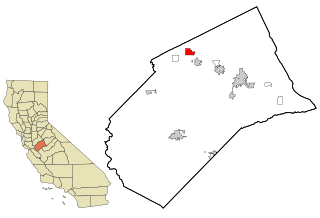
Lamont is a census-designated place (CDP) in Kern County, California, United States. Lamont is located 9 miles (14 km) south-southeast of downtown Bakersfield, at an elevation of 404 feet (123 m). The population was 15,120 at the 2010 census, up from 13,296 at the 2000 census.

Delhi, California Census designated place in California, United States

Delhi is a census designated place (CDP) in Merced County in the U.S. state of California. Delhi is 18 miles (29 km) west-northwest of Merced, at an elevation of 118 feet. According to the 2010 census, the population was 10,755 up from 8,022 at the 2000 census.

Aromas, California census-designated place in California, United States

Aromas is a census-designated place (CDP) in Monterey County, and San Benito County, California, United States. The population was 2,650 at the 2010 census.

Pajaro, California Census designated place in California, United States

Pajaro is a census-designated place (CDP) in Monterey County, California, United States. Pajaro is located on the south bank of the Pajaro River 5 miles (8 km) northeast of its mouth, at an elevation of 26 feet. The population was 3,070 at the 2010 census, down from 3,384 at the 2000 census. The school district is in Santa Cruz County.

Glen Avon, California Former census-designated place in California, United States

Glen Avon was a census-designated place (CDP) in Riverside County, California, United States. The population was 20,199 at the 2010 census, up from 14,853 at the 2000 census. On July 1, 2011, the CDP became part of the newly incorporated City of Jurupa Valley.

Gold River, California Census-designated place in California, United States

Gold River is a census-designated place (CDP) in Sacramento County, California. The population was 7,812 at the 2010 census, down from 8,023 at the 2000 census. Gold River is part of the Sacramento–Arden-Arcade–Roseville Metropolitan Statistical Area. With a median family income of over $117,000, Gold River is the highest-income place in Sacramento County.

Joshua Tree, California census-designated place in California, United States

Joshua Tree is a census-designated place (CDP) in San Bernardino County, California, United States. The population was 7,414 at the 2010 census. At approximately 2,700 feet above sea level, Joshua Tree and its surrounding communities are located in the High Desert of California. The center of the business district in Joshua Tree is on California State Route 62.

Casa Conejo, California Census-designated place in California, United States

Casa Conejo is an unincorporated county island in Newbury Park, Ventura County, California, United States. It was the first planned community in Newbury Park and began building in 1960. When the city of Thousand Oaks incorporated 4 years later, the new developments in Newbury Park were incorporated into the city boundaries before being subdivided. The community is bordered by Old Conejo Road and the US 101 to the North, Borchard Road to the South, Jenny Dr. to the West, and Sequoia Middle School to the East. For statistical purposes, the United States Census Bureau has defined Casa Conejo as a census-designated place (CDP). The census definition of the area may not precisely correspond to local understanding of the area with the same name. The population was 3,249 at the 2010 census, up from 3,180 at the 2000 census. Casa Conejo is located in a roughly rectangle-shaped unincorporated area surrounded by the city of Thousand Oaks.

Del Monte Forest, California census-designated place in California, United States

Del Monte Forest is a census-designated place (CDP) in Monterey County, California. As of the 2010 census, the CDP had a total population of 4,514, down from 4,532 at the 2000 census. The census area includes the separate well-known community of Pebble Beach. Alternatively Del Monte Forest is a habitat area of the same location, which originally occupied considerably more area prior to urban development of the 20th century. The forest is dominated by Monterey Pine, but also contains other important tree species and a variety of rare and endangered plant species.

Loma Mar, California Census-designated place in California, United States

Loma Mar is a census-designated place (CDP) in San Mateo County, California. It is near San Mateo County Memorial Park on Pescadero Road and is in area code 650. Loma Mar is between the towns of Pescadero and La Honda, situated in the Santa Cruz Mountains in the western part of the San Francisco Peninsula. The United States Postal Service has assigned it ZIP Code 94021. As of the census of 2010, there were 113 residents in the CDP. Loma Mar is home to the YMCA's Camp Loma Mar.

Garey, California census-designated place in California, United States

Garey is a census-designated place in Santa Barbara County, California located east of U.S. Route 101 about 10 miles (16 km) southeast of Santa Maria and 5 miles (8.0 km) north of Sisquoc. The ZIP Code is 93454, and the community is inside area code 805. The population was 68 at the 2010 census.

Butte Valley, California Unincorporated community in California, United States

Butte Valley is an unincorporated community and census-designated place (CDP) named for a former settlement in Butte County, California, United States. It is located 5.5 miles (8.9 km) southeast of Chico. A post office operated at Butte Valley from 1861 to 1871, when it was re-located to Durham. Butte Valley sits at an elevation of 351 feet. The 2010 United States census reported Butte Valley's population is 899.

Montalvin Manor, California Census-designated place in California, United States

Montalvin Manor is a census-designated place (CDP) in Contra Costa County, California. It lies at an elevation of 69 feet. For census purposes, it formed part of Bayview-Montalvin, California until 2010, when it became a separate CDP with a population of 2,876. The other half of the old CDP became Bayview.

Malaga, California census-designated place in California, United States

Malaga is a census-designated place in Fresno County, California. It is located 6 miles (9.7 km) south-southeast of downtown Fresno, at an elevation of 295 feet. As of the 2010 census, Malaga had a population of 947.

Green Acres, California census-designated place in California, United States

Green Acres is a census-designated place in Riverside County, California. Green Acres sits at an elevation of 1,555 feet (474 m). The 2010 United States census reported Green Acres's population was 1,805.

Kingvale, California census-designated place in California, United States

Kingvale is a census-designated place (CDP) in Placer County and Nevada County, California, United States. The CDP straddles the border of the two counties, with Nevada County to the north and Placer County to the south. It is located near Soda Springs, 5.5 mi (8.9 km) west of Donner Pass. Kingvale was listed on an official map as of 1955. The population was 143 at the 2010 census.

French Valley, California census-designated place in California, United States

French Valley is a census-designated place in Riverside County, California. French Valley sits at an elevation of 1,368 feet (417 m). French Valley lies in the French Valley of California. The 2010 United States census reported French Valley's population was 23,067. It became the most populous CDP in Riverside County when Rubidoux was incorporated into Jurupa Valley.

Desert Palms, California census-designated place in California, United States

Desert Palms is a census-designated place in the Coachella Valley of eastern Riverside County, southern California.

Lake California, California census-designated place in California, United States

Lake California is a census-designated place (CDP) in Tehama County, California. Lake California sits at an elevation of 597 feet (182 m). The 2010 United States census reported Lake California's population was 3,054.

References