
Golfland Entertainment Centers are a chain of family amusement centers, miniature golf courses, and water parks located in California and Arizona. The company was founded in 1953.
Golfland Entertainment Centers are a chain of family amusement centers, miniature golf courses, and water parks located in California and Arizona. The company was founded in 1953.
The Golfland locations in Stanton and Sunnyvale, California were hotbeds for the burgeoning fighting game community in the 1990s, with many players congregating in Golfland arcade halls to play Street Fighter II . Golfland USA in Sunnyvale was the location of Battle by the Bay in 1996, the first nationwide fighting game tournament. [1] [2]
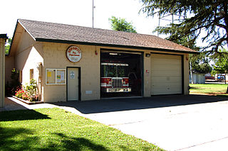
Golfland Sunsplash is a family entertainment center and waterpark located in Mesa, AZ. The location is separated into two parks. Golfland operates as a year-round FEC and features three miniature golf courses, an arcade, a pizza restaurant, a go-cart track, bumper cars, and bumper boats. Sunsplash operates in the summer and features 29 water-based attractions.
The park opened in 1983 and the water park opened in 1986.
In the movie Bill & Ted's Excellent Adventure , Bill, Ted, and Napoleon visit a fictional waterpark called Waterloo in San Dimas, CA. The scenes at Waterloo are a cross between establishing shots at San Dimas Raging Waters and shots with the actors at Golfland Sunsplash.

Foothill Farms is a census-designated place (CDP) and unincorporated community in Sacramento County, California, USA. It is part of the Sacramento–Arden-Arcade–Roseville Metropolitan Statistical Area. The population was 33,121 at the 2010 census, up from 17,426 at the 2000 census. Foothill Farms is part of the greater North Highlands-Foothill Farms community, and comprises the zip codes 95841 and 95842. Susan Ual services as President of the New Foothill Farms Community Association while Michael Baker services as the President of the Old Foothill Farms Community Association
www.oldfoothillfarms.org

La Riviera is a census-designated place (CDP) in Sacramento County, California, United States. It is part of the Sacramento–Arden-Arcade–Roseville Metropolitan Statistical Area. The population was 10,802 at the 2010 census, up from 10,273 at the 2000 census. La Riviera is a primarily residential neighborhood located between the American River on the North side and Highway 50 on the southern border.

North Highlands is a census-designated place (CDP) in Sacramento County, California, United States. It is part of the Sacramento–Arden-Arcade–Roseville Metropolitan Statistical Area. The population was 42,694 at the 2010 census, down from 44,187 at the 2000 census.

Vineyard is a census-designated place (CDP) in Sacramento County, California, United States. It is part of the Sacramento–Arden-Arcade–Roseville Metropolitan Statistical Area. The population was 24,836 at the 2010 census, up from 10,109 at the 2000 census. Along with more than doubling its population in just one decade, Vineyard also grew to become one of Greater Sacramento's most racially diverse suburbs.

Sunnyvale is a city located in the Santa Clara Valley in northwest Santa Clara County in the U.S. state of California.
Esparto is a census-designated place (CDP) in Yolo County, California, United States. It is part of the Sacramento–Arden-Arcade–Roseville Metropolitan Statistical Area. The population was 3,108 at the 2010 census.

The Diocese of San José in California is a Latin Church ecclesiastical territory, or diocese, of the Catholic Church in Santa Clara County in California in the United States. It is a suffragan diocese of the metropolitan Archdiocese of San Francisco.
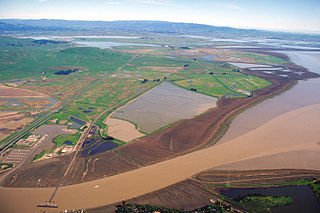
Sears Point is a prominent landform that juts into the San Pablo Bay in Sonoma County, California, United States. This hill is the southernmost peak of the Sonoma Mountains and forms the southwestern ridge above Tolay Lake. Starting with European settlement of this area in the mid-19th century considerable modification of the Napa Sonoma Marsh began to occur, such that in contemporary times, there is considerable upland between Sears Point and San Pablo Bay. Numerous local conservation organizations are presently working to restore hundreds of acres of these historic tidal wetlands as part of the Sears Point Wetlands and Watershed Restoration Project. The region can be accessed via State Route 37 or State Route 121.

Mather Air Force Base was a United States Air Force Base, which was closed in 1993 pursuant to a post-Cold War BRAC decision. It was located 12 miles (19 km) east of Sacramento, on the south side of U.S. Route 50 in Sacramento County, California. Mather Field was one of 32 Air Service training camps established after the United States entry into World War I in April 1917.
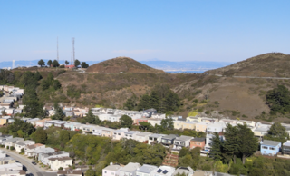
The Twin Peaks are two prominent hills with an elevation of about 925 feet (282 m) located near the geographic center of San Francisco, California. The Twin Peaks are the second and third highest mountains in the city; only 928 foot (283 m) Mount Davidson is higher within San Francisco city limits.

Area codes 408 and 669 are telephone area codes in the North American Numbering Plan (NANP) in the U.S. state of California. The numbering plan area comprises most of Santa Clara County and Northern Santa Cruz County, and includes Gilroy, Morgan Hill, Saratoga, Los Gatos, Monte Sereno, Milpitas, Sunnyvale, Santa Clara, Cupertino, Campbell, and San Jose.
The Santa Clara County Library District is a public library system for Santa Clara County headquartered in Campbell, California. The library serves the communities and cities of Campbell, Cupertino, Gilroy, Los Altos, Los Altos Hills, Milpitas, Monte Sereno, Morgan Hill, Saratoga, and all unincorporated areas of Santa Clara County. Other cities in Santa Clara County run their own library systems. In addition to these libraries, the library provides mobile library service with a bookmobile which visits preschools, retirement communities, migrant farmworker camps, and rural communities without easy access to library services. In 2020, SCCLD also launched a new website featuring a 24/7 online library.
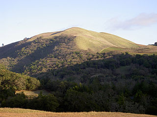
Bald Mountain is a name given to over fifty summits in California.

Santa Clara Valley Medical Center, commonly known as Valley Medical Center or simply Valley Medical, is a prominent 731-bed public tertiary, teaching, and research hospital in San Jose, California. Located in the Fruitdale neighborhood of West San Jose, Valley Medical Center is the anchor facility of the Santa Clara County Health System, serving Santa Clara County. Valley Medical is home to numerous innovative research and care centers, such as the Rehabilitation Trauma Center, the only federally-designated spinal cord injury center in Northern California.
From 1577 to 1580 Sir Francis Drake circumnavigated the world. In 1579 as part of this voyage he landed on the west coast of North America which consequently has drawn the attention of scores of historians, geographers, linguists, anthropologists and other professionals. In addition, many history buffs have sought to locate Drake's New Albion. The established site for Drake's 1579 landing at New Albion is at Drake's Cove in Drakes Bay in Marin County, California. More than a score of ideas for an alternative to Drake's New Albion claim have been put forth which cover the coast from Alaska to Baja California Sur, Mexico. These ideas span the eighteenth through the early twenty-first centuries.
The Newby Island Landfill (NISL) is one of the largest active landfills on the shores of the San Francisco Bay. It is located in Santa Clara County, California in the United States. The site is located within the city limits of San Jose, California at the western terminus of Dixon Landing Road. The address is 1601 Dixon Landing Road, Milpitas. Although the address and public street access to the site are both in the City of Milpitas, the landfill property is entirely within the City of San Jose. Newby Island Landfill has a length of 5.07 km (3.15 mi). It is located West of the City of Milpitas near Dixon Landing Road and Interstate 880. It is the terminus for waste for all of San Jose (62%), Santa Clara (14%), Milpitas (10%), Cupertino (5%), Los Altos (2%) and other cities (7%). The 342-acre pile is currently permitted to operate until 2041 and may extend up to 245 feet. The landfill is an island surrounded by a levee which keeps its runoff from directly entering the bay, and the water that drains from it is treated in the landfill's own treatment plant. Electricity for the landfill is generated by burning the methane collected from the decomposition of the waste. Dried sewage sludge from the nearby San José–Santa Clara Regional Wastewater Facility is the material used as cover, mixed in with the trash, blending San Jose's waste streams. It is operated by Republic Services (Republic), which, along with Waste Management Incorporated, transports and disposes of most of the household trash in the United States.

The Santa Clara County Fairgrounds is an event venue in San Jose, California. The 165-acre (67 ha) fairgrounds has been owned by the County of Santa Clara since 1940 and is operated by the Santa Clara County Fairgrounds Management Corporation, a public-benefit nonprofit corporation.

The San José–Santa Clara Regional Wastewater Facility is a wastewater treatment plant located in the Alviso neighborhood of San Jose, California. The facility treats 110 million U.S. gallons of wastewater per day, with a capacity of up to 167 million U.S. gal/d (630 ML/d), making it the largest tertiary treatment plant in the western United States. It serves 1.5 million residents and over 17,000 business facilities in eight cities. The 2,600-acre (1,100 ha) site is operated by the San Jose Environmental Services Department and jointly owned by the cities of San Jose and Santa Clara. It began operations in 1956 to address severe water pollution issues and played a key role in San Jose's aggressive annexation program during the 1950s and 1960s.