The North Complex Fire burned southwest, from Highway 70 near Quincy to Lake Oroville
The general location of the fire in Northern California
The North Complex Fire was a massive wildfire complex that burned in the Plumas National Forest in Northern California in the counties of Plumas and Butte.[2] Twenty-one fires were started by lightning on August 17, 2020; by September 5, all the individual fires had been put out with the exception of the Claremont and Bear Fires, which merged on that date, and the Sheep Fire, which was then designated a separate incident. On September 8, strong winds caused the Bear/Claremont Fire to explode in size, rapidly spreading to the southwest. On September 8, 2020, the towns of Berry Creek and Feather Falls were immediately evacuated at 3:15p.m. PDT with no prior warning. By September 9, 2020, the towns of Berry Creek and Feather Falls had been leveled, with few homes left standing. The fire threatened the city of Oroville, before its westward spread was stopped. The fire killed 16 people and injured more than 100. The complex burned an estimated 318,935 acres (129,068ha), and was 100% contained on December 3.[1] The fire was managed by the U.S. Forest Service in conjunction with Cal Fire, with the primary incident base in Quincy. The North Complex Fire is the eighth-largest in California's history,[3] and was the deadliest fire in the 2020 California wildfire season.[4]
On August 17, 2020, dry thunderstorms sparked 21 wildfires in the Plumas National Forest and Lassen National Forest, the largest of which were the Claremont and Bear Fires along the canyon of the Middle Fork Feather River. The storms came from a large plume of moisture from Tropical Storm Fausto that were carried into California, which started hundreds of wildfires simultaneously across Northern and Central California. By August 22, 16 of the original 21 fires had been contained.[5] The Sheep Fire near Susanville was originally included as part of the North Complex,[6] but on September 5, it was assigned to a separate incident.[7] The Sheep Fire burned about 29,570 acres (11,970ha), before it was fully contained on September 9.[8]
Claremont Fire
The Claremont Fire was spotted around 9:00a.m. PDT on August 17.[9] The fire originated along Claremont Creek, a tributary of the Middle Fork just south of Quincy, and quickly jumped the ridge northwards towards American Valley. On August 20 an evacuation advisory was issued for East Quincy[10] which was quickly changed to a mandatory evacuation for East Quincy and residents along Quincy-La Porte Road. On August 22 the fire jumped California State Route 70 at the Massack Rest Area southeast of Quincy.[5] On August 23, aided by high winds, the fire began advancing rapidly east forcing Spring Garden and Greenhorn to be evacuated.[11] The fire threatened State Route 70 and the Union Pacific Railroad tracks, shutting both down intermittently for several days.
On August 27, the Claremont Fire was at 20,697 acres (8,376ha) and 47percent contained.[12] Mandatory evacuations were lifted in East Quincy, but with continued strong west winds, Greenhorn and Sloat to the east were evacuated on August 28.[13] On August 30 crews conducted backfire operations on the eastern side of the fire and prevented it from spreading towards Spring Garden and Cromberg.[14] On September 1 mandatory evacuations were lifted for Quincy-La Porte Road.[15] On September 5, with fire activity much lower on the eastern sides, evacuation orders were lifted for Spring Garden, Greenhorn, Sloat and Cromberg.[16] On the morning of August 31, the North Complex Fire was at 22,780 acres (9,220ha), and 59percent contained.[17] On the morning of September 4 it had grown to 24,330 acres (9,850ha), and containment had dropped to 49percent.[18]
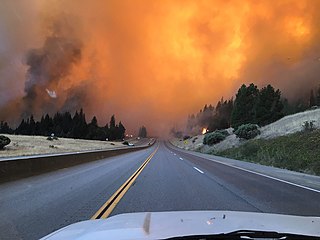
Bear Fire
Bear Fire on Highway 162, 10 September
The Bear Fire was also spotted around 9:00a.m. on August 17,[19] in the Middle Fork canyon west of the Claremont Fire near the Pacific Crest Trail. The fire started in rough, roadless country along the Wild and Scenic section of the Middle Fork. An effort was made to staff the fire on August 18, but an increase in fire activity forced fire crews to withdraw. After that point, because of limited firefighting resources, the Bear Fire was left unstaffed because it wasn't immediately a threat to people or property, it was in steep, rugged terrain, and resources were scarce due to the fires burning across the state. Efforts were concentrated on the Claremont Fire.[20] By August 23, it was at 1,661 acres (672ha).[21] On August 26, some areas around Bucks Lake were placed under evacuation advisory due to increased fire activity on the Bear Fire.[22] Crews also were working on containment line to the northeast as the fire expanded slightly towards Quincy.[23] By August 31 it had grown to 9,570 acres (3,870ha), and was still 0percent contained.[17] On the morning of September 4 it was at 12,154 acres (4,919ha), and was 29percent contained.[18]
While crews concentrated on structure protection and building containment line around the perimeter of the fires, the unpopulated area between the Claremont and Bear fires was allowed to burn naturally with the help of backfiring operations,[24] and the two fires merged on September 5,[25] at a combined 39,779 acres (16,098ha). A total of 1,386 personnel were assigned to the fire.[26] The southern boundary of the fire was mostly held along the Middle Fork, and crews worked to build secondary containment lines south of the river.[27] Flames crossed the river in a few areas but were quickly contained.
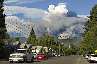
On the morning of September 8 a dry cold front moved in, bringing strong northeast winds and threatening the incomplete containment line along the river.[28] At about 10:00a.m., the fire jumped the river near Horshoe Bend and began heading rapidly southwest. With winds gusting to 45 miles per hour (72km/h), the spot fire had grown to 1,000 acres (400ha) within an hour, and by 3:00p.m. it had grown to more than 20,000 acres (8,100ha). At 11:50a.m., mandatory evacuations were issued for La Porte and Little Grass Valley Reservoir.[29] As winds picked up throughout the day, evacuation orders were issued by 3:25p.m. for several communities in Butte County including Feather Falls, Clipper Mills, Berry Creek, Brush Creek, Woodleaf and Forbestown, and around Miners Ranch Road and California State Route 162.[30] Evacuation orders were also effective in Yuba County for residents along La Porte Road, New York Flat Road, and around Brownsville and New Bullards Bar Reservoir.[31][32] By the afternoon of September 8 the fire had burned more than 58,000 acres (23,000ha). At 11:00p.m. PDT, Kelly Ridge and Copley Hills, near Lake Oroville, were evacuated, as officials predicted strong winds would lead to continuing extreme fire behavior.[33]
On the early morning of September 9, evacuation warnings were issued for more areas around Lake Oroville, Concow and Paradise[34][35] and in Plumas County, a mandatory evacuation order was issued for Bucks Lake[36] and an evacuation advisory for Meadow Valley.[37] As predicted, high winds continued to drive the fire rapidly downhill and southwest, traveling 20 miles (32km) to Lake Oroville in a few hours, threatening the city of Oroville.[38] By 8:35a.m., the fire was estimated at more than 150,000 acres (61,000ha).[20] The entire town of Berry Creek was destroyed,[39] with only 3 houses left standing in the town of 1,200.[40] Homes were also burned in several nearby communities, such as Feather Falls. Daniel Swain, a climate scientist at University of California Los Angeles, compared the explosive wind-driven spread with the 2018 Camp Fire, which occurred just north of this area.[41]
At 4:00p.m. PDT on September 9, the fire had jumped the southern arm of the lake and was burning in the hills above Oroville. It had also traveled as far west as the North Fork Feather River, threatening Paradise, although the burn scar from the Camp Fire slowed fire activity.[42][43] On the south, the fire reached the South Fork Feather River, burning around the north side of Little Grass Valley Reservoir and approaching Forbestown. The city of Oroville and surrounding foothill communities were under an evacuation warning. As of 5:00p.m., at least three people were dead and twelve missing; at least 100 people were rescued. An estimated 2,000 buildings had been destroyed.[44] On the evening of September 9, the fire was estimated at 252,163 acres (102,047ha) 24percent containment.[45]
On September 10, the section of the fire that had burned into the Cal Fire protection zone was labeled as the North Complex West Zone. The approximately 70,000 acres (28,000ha) section mostly outside of the Plumas National Forest was managed by Cal Fire. On September 10 authorities reported the number of confirmed deaths had increased to ten, and 16 people were reported missing.[46] Due in part to a reversal of wind direction, the fire did not burn significantly more acreage on September 10. On the same day, the burn area was revised to 244,203 acres (98,825ha), with 23percent containment.[47]
By September 11, winds had shifted to the southwest, blowing the fire front and smoke back over the burn area and towards Quincy. Fire activity was significantly decreased from the previous day, allowing crews to work on containment lines protecting homes around Bucks Lake and Little Grass Valley Reservoir.[48] By the morning of September 12, the fire was at 252,313 acres (102,107ha) and 21percent contained. A total of 3,282 personnel were assigned to the fire.[49]
On September 14, the fire had increased in size to 264,374 acres (106,988ha), with most growth along the north flank of the fire. Containment was increased to 38percent.[50] On September 15 continued southwest winds caused the fire to jump containment lines near Red Mountain, moving northeast towards Bucks Lake.[51] On September 16 high fire activity continued near Red Mountain, with spot fires starting in the Grizzly Lake area. The fire was also active and growing in Onion Valley south of Quincy. In the meantime, firefighters made progress on containment lines along the southeast flank of the fire, between Sly Creek Reservoir and Little Grass Valley Reservoir. The fire was at 273,335 acres (110,615ha) and 36percent contained.[52]
On the morning of September 17, evacuation orders were issued for Meadow Valley and Tollgate as fire activity continued to pick up on the north side.[53] By September 18, firefighters had extended containment lines up from Sly Creek Reservoir to Onion Valley. The spot fire at Grizzly Lake was contained, but not before burning 200 acres (81ha). The fire was at 287,354 acres (116,288ha), and containment was increased to 54percent.[54] On September 22, the North Complex reached 300,204 acres (121,488ha), and was 75percent contained. Most of the growth had occurred on the northwest side of the fire as it continued to expand towards Bucks Lake.[55]
On September 27, strong sustained winds picked up once again, starting spot fires outside of containment lines, including one on French Hotel Creek.[56] An evacuation order was issued for Pulga, Concow, Big Bend and Yankee Hill as the fire moved west towards the North Fork Feather River Canyon.[57] By the morning of September 29, the fire was within a few hundred yards of Highway 70, which was closed between Greenville Wye (west of Quincy) and Cherokee Road (east of Oroville).[58] The North Complex was at 308,995 acres (125,046ha) and 76percent contained.[59]
On December 3, the North Complex was declared 100% contained at 318,935 acres.[60]
Effects
Casualties
Perimeter of North Complex Fire
The North Complex killed sixteen people. Fourteen were residents of Berry Creek, and two were residents of Feather Falls.[61] The first report of fatalities came from the Butte County Sheriff, who announced the discovery of three victims of the fire on Wednesday, September 9.[62] Seven more deaths were reported on Thursday, September 10, bringing the toll to ten people, while sixteen people remained missing.[63] The death toll was temporarily lowered from ten to nine people on September 11 after a skeleton discovered in a burned storage shed was determined to have been an anatomical model belonging to an anthropology student, and not that of a victim.[64][65]
The Butte County Sheriff's office announced the discovery of three more sets of remains on Saturday, September 12, with thirteen still missing.[66] The discovery of two bodies was announced on Sunday, September 13,[67] followed by another on Monday, September 14.[68] The death toll remained at fifteen until October 28, 2020, when the Butte County Sheriff's Office announced that a 54-year-old male resident of Berry Creek had passed away from lingering burn injuries one week prior.[61] Approximately twenty people were hospitalized with burn injuries.[65]
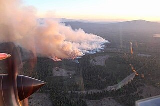
Air quality
Smoke from Bear Fire in Oroville
Smoke from the fire created extremely unhealthy air conditions in Quincy and nearby communities for several weeks. After the fire grew explosively in size on September 9, smoke reached the Sacramento Valley and the San Francisco Bay area (where the effects of the smoke led to the day being referred to as Orange Skies Day) with ash falling from the sky between Danville, San Jose, and San Francisco.[69]
Political response
Gavin Newsom signing AB2147 in the North Complex Fire burn zone
On September 11, Governor Newsom visited the North Complex to talk about climate change and signed AB2147 into law, which allows former inmate firefighters to pursue a professional career in firefighting. He utilized the opportunity for social media.[70][71]
Several Republican legislators from the region pushed back on the governor's comments following his visit. Doug LaMalfa, the House representative for California's 1st district, criticized Newsom's "audacity to come tour the North Complex and peddle his climate change agenda while offering zero solutions to alleviate the pain of our people or get these fires under control". State senator Jim Nielsen and assemblyman James Gallagher issued a press release calling Newsom's comments a deflection from "the fundamental failure to address the fuels build-up in our forests that are the cause of these devastating fires".[72]
In the summer of 2013, there were several major wildfires in Colorado in the United States. During June and July, record high temperatures and dry conditions fueled the fires all across the state. By July 24, 570 structures had been destroyed and 2 people died. Below is a list of the major fires of the year.
The Lolo Peak Fire was a wildfire in Lolo National Forest and Bitterroot National Forest, Montana in the United States, that began by lightning strikes on the western flank of Lolo Peak, 10 miles southwest of Lolo, Montana on July 15, 2017. The fire burned a total of 53,902 acres (218 km2). One firefighter, Brent Witham, was killed working the fire, and another firefighter was injured. Two homes were destroyed, over 3,000 people were evacuated and 1,150 residences were threatened. The fire threatened homes along Highway 12 and Highway 93, impacting recreational activities in the area and the communities of Lolo and Florence.
The Uno Peak Fire was a wildfire on the slopes of Lake Chelan, approximately 15 miles from Manson, Washington in the United States. The human caused fire was started on August 30, 2017. The fire burned a total of 8,726 acres (35 km2).
The Ferguson Fire was a major wildfire in the Sierra National Forest, Stanislaus National Forest and Yosemite National Park in California in the United States. The fire was reported on July 13, 2018, burning 96,901 acres (392 km2), before it was 100% contained on August 19, 2018. Interior areas of the fire continued to smolder and burn until September 19, 2018, when InciWeb declared the fire to be inactive. The Ferguson Fire was caused by the superheated fragments of a faulty vehicle catalytic converter igniting vegetation. The fire, which burned mostly in inaccessible wildland areas of the national forest, impacted recreational activities in the area, including in Yosemite National Park, where Yosemite Valley and Wawona were closed. The Ferguson Fire caused at least $171.2 million in damages, with a suppression cost of $118.5 million and economic losses measuring $52.7 million. Two firefighters were killed and nineteen others were injured in the fire.
The Mendocino Complex Fire was a large complex of wildfires that burned in northern California for more than three months in 2018. It consisted of two wildfires, the River Fire and Ranch Fire, which burned in Mendocino, Lake, Colusa, and Glenn Counties in California, with the Ranch Fire being California's single-largest recorded wildfire at the time until the August Complex fire in 2020. The Ranch Fire burned eight miles northeast of Ukiah, and the River Fire burned six miles north of Hopland, to the south of the larger Ranch Fire. First reported on July 27, 2018, both fires burned a combined total of 459,123 acres (1,858 km2), before they were collectively 100% contained on September 18, though hotspots persisted until the complex was fully brought under control on January 4, 2019. The Ranch Fire alone burned 410,203 acres (1,660 km2), making it the largest wildfire in modern California history at the time until the August Complex fire that occurred in 2020. The Ranch Fire also surpassed the size of the 315,577-acre Rush Fire, which burned across California and Nevada, as well as the Santiago Canyon Fire of 1889, which was previously believed to have been California's all-time largest wildfire.
The Delta Fire was a 2018 wildfire that burned near Lakehead, California, in the Shasta National Forest. The fire burned 63,311 acres (256 km2) and destroyed 20 structures, before it was 100% contained on October 7, 2018. The fire burned into the western flank of the nearby Hirz Fire on September 10, and also burned only a couple of miles away from the enormous Carr Fire, the seventh-most destructive fire in Californian history.
By the end of 2019, according to Cal Fire and the US Forest Service, 7,860 wildfires were recorded across the U.S. state of California, totaling an estimated of 259,823 acres of burned land. These fires caused 22 injuries, 3 fatalities, and damaged or destroyed 732 structures. The 2019 California fire season was less active than that of the two previous years, which set records for acreage, destructiveness, and deaths.
2020 was a record-setting year for wildfires in California. Over the course of the year, 8,648 fires burned 4,304,379 acres (1,741,920 ha), more than four percent of the state's roughly 100 million acres of land, making 2020 the largest wildfire season recorded in California's modern history. However, it is roughly equivalent to the pre-1800 levels which averaged around 4.4 million acres yearly and up to 12 million in peak years. California's August Complex fire has been described as the first "gigafire", burning over 1 million acres across seven counties, an area larger than the state of Rhode Island. The fires destroyed over 10,000 structures and cost over $12.079 billion in damages, including over $10 billion in property damage and $2.079 billion in fire suppression costs. The intensity of the fire season has been attributed to a combination of more than a century of poor forest management and higher temperatures resulting from climate change.
The Bush Fire was a human-caused wildfire that started in the Tonto National Forest northeast of Phoenix, Arizona. It burned 193,455 acres (78,288 ha). The fire started on June 13, 2020 near the intersection of Bush Highway and SR 87 and was fully contained on July 6, 2020
The 2020 Utah wildfire season was a series of prominent wildfires throughout the state of Utah, lasting from June 1 through October 30, as defined by state law. Part of the 2020 Western United States wildfire season, Utah saw record-breaking numbers of human-caused fires. The largest fire of the season, the East Fork Fire, burned an area of 89,568 acres. In total, the suppression costs for the fires amounted to at least $103 million.
The Apple Fire was a wildfire that burned during the 2020 California wildfire season in Cherry Valley south of Oak Glen and north of Beaumont and Banning in Riverside County, California in the United States. The fire ignited on Friday, July 31, 2020 as three separate smaller blazes within the rural canyons along Oak Glen Road before merging and rapidly expanded to 1,900 acres (769 ha) and destroyed at least one home and two outbuildings in the Cherry Valley area. It now covers at least 33,424 acres (13,526 ha) and created "a plume of smoke so massive that it generated its own winds." The fire was sparked by a diesel-burning vehicle that emitted burning carbon. The fire was named after one of the roadways close to the ignition site, which is named Apple Tree Lane.
The 2020 Loyalton Fire was a large wildfire in Lassen, Plumas and Sierra counties in California and Washoe County in Nevada. After it was ignited by lightning on August 14, 2020, the fire burned 47,029 acres (19,032 ha) in the Tahoe National Forest and the Humboldt-Toiyabe National Forest before it was fully contained on August 26. The Loyalton Fire was notable for generating three fire tornadoes on August 15, necessitating first-of-their-kind warnings by the National Weather Service.
The Western United States experienced a series of major wildfires in 2020. Severe August thunderstorms ignited numerous wildfires across California, Oregon, and Washington, followed in early September by additional ignitions across the West Coast. Fanned by strong, gusty winds and fueled by hot, dry terrains, many of the fires exploded and coalesced into record-breaking megafires, burning more than 10.2 million acres of land, mobilizing tens of thousands of firefighters, razing over ten thousand buildings, and killing at least 37 people. The fires caused over $19.884 billion in damages, including $16.5 billion in property damage and $3.384 billion in fire suppression costs. Climate change and poor forest management practices contributed to the severity of the wildfires.
The 2020 Colorado wildfire season was a series of significant wildfires that burned throughout the U.S. state of Colorado as part of the 2020 Western United States wildfire season. With a total of 665,454 acres (269,300 ha) burned, and the 3 largest fires in state history, it is Colorado's largest wildfire season on record.
The 2020 Lassen County wildfire season included seven large wildfires that burned entirely or in part in Lassen County. A total of 203,296 acres (82,271 ha) of land was burned in Lassen County, making it one of the larger clusters of fires in the 2020 California wildfire season.
By the end of 2021, a total of 8,835 wildfires burned 2,568,948 acres (1,039,616 ha) across the U.S. state of California. Approximately 3,629 structures were damaged or destroyed by the wildfires, and at least seven firefighters and two civilians were injured.
Wildfires across the US state of Arizona burned 524,428 acres (212,228 ha) of land in at least 1,773 fires, fueled in part by a drought, hot temperatures, and thunderstorms producing dry lightning. At one point in late June, over 20 active wildfires were burning across the state.
The 2020 Maricopa County wildfires were a series of major and non-major wildfires that took place in Maricopa County, Arizona, from the month of May to the month of October. In the year 2020, Arizona saw one of its worst fire seasons in the states history. Due to the lack of precipitation needed in Arizona, the state fell into an ongoing drought from late 2020 and 2021. High winds were also present during the summer when fire season is mostly active in the state. These factors led to the wildfires in Maricopa County to be destructive and costly.
The 2022 Calf Canyon/Hermits Peak Fire was the largest and most destructive wildfire in the history of New Mexico. The fire burned 341,471 acres between early April and late June in the southern Sangre de Cristo Mountains, in San Miguel, Mora, and Taos counties. It was the most significant fire of the record-breaking 2022 New Mexico wildfire season, as well as the largest wildfire of the year in the contiguous United States. The fire destroyed at least 903 structures, including several hundred homes, and damaged 85 more.
This page is based on this Wikipedia article Text is available under the CC BY-SA 4.0 license; additional terms may apply. Images, videos and audio are available under their respective licenses.