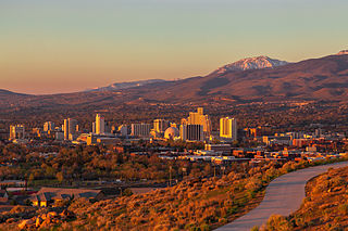
Reno is a city in the northwest section of the U.S. state of Nevada, along the Nevada-California border, about 22 miles (35 km) north from Lake Tahoe, known as "The Biggest Little City in the World". Known for its casino and tourism industry, Reno is the county seat and most populous city of Washoe County and sits in the High Eastern Sierra foothills, in the Truckee River valley, on the eastern side of the Sierra Nevada. The Reno metro area occupies a valley colloquially known as the Truckee Meadows, it is the 81st most populous city in the United States.

Washoe County is a county in the U.S. state of Nevada. As of the 2020 census, the population was 486,492, making it Nevada's second-most populous county. Its county seat is Reno. Washoe County is included in the Reno, NV Metropolitan Statistical Area.

Pyramid Lake is the geographic sink of the basin of the Truckee River, 40 mi (64 km) northeast of Reno, Nevada, United States.

The Truckee River is a river in the U.S. states of California and Nevada. The river flows northeasterly and is 121 miles (195 km) long. The Truckee is the sole outlet of Lake Tahoe and drains part of the high Sierra Nevada, emptying into Pyramid Lake in the Great Basin. Its waters are an important source of irrigation along its valley and adjacent valleys.

The Carson River is a northwestern Nevada river that empties into the Carson Sink, an endorheic basin. The main stem of the river is 131 miles (211 km) long although the addition of the East Fork makes the total length 205 miles (330 km), traversing five counties: Alpine County in California and Douglas, Storey, Lyon, and Churchill Counties in Nevada, as well as the Consolidated Municipality of Carson City, Nevada. The river is named for Kit Carson, who guided John C. Frémont's expedition westward up the Carson Valley and across Carson Pass in winter, 1844. The river made the National Priorities List (NPL) on October 30, 1990 as the Carson River Mercury Superfund site (CRMS) due to investigations that showed trace amounts of mercury in the wildlife and watershed sediments.

The Comstock Lode is a lode of silver ore located under the eastern slope of Mount Davidson, a peak in the Virginia Range in Virginia City, Nevada, which was the first major discovery of silver ore in the United States and named after American miner Henry Comstock.
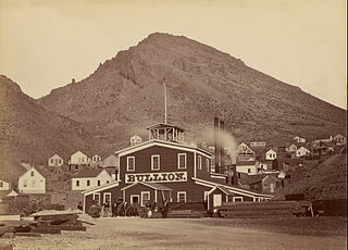
The Virginia Range is a mountain range of western Nevada, primarily within Storey County, and extending east into Lyon County. The range is named after James Finney, "Old Virginny", an early discoverer of gold associated with the Comstock Lode.

The Virginia and Truckee Railroad is a privately owned heritage railroad, headquartered in Virginia City, Nevada. Its private and publicly owned route is 14 miles (23 km) long. When first constructed in the 19th century, it was a commercial freight railroad which was originally built to serve the Comstock Lode mining communities of northwestern Nevada.
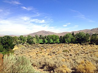
The Truckee Meadows is a valley in Northern Nevada, named for the Truckee River, which collects and drains all water in the valley. Truckee Meadows is also colloquially used as a name for the Reno–Tahoe-Fernley CSA area, even though the metro area includes areas outside this valley. The name for the valley in the Washo language is Welganuk.

Steamboat Springs is a small volcanic field of rhyolitic lava domes and flows in western Nevada, located south of Reno. There is extensive geothermal activity in the area, including numerous hot springs, steam vents, and fumaroles. The residential portions of this area, located mostly east of Steamboat Creek and south of modern-day SR 341, are now known simply as Steamboat.
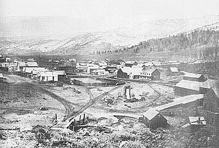
Old Washoe City is a ghost town in Washoe County, Nevada, in the United States. Nearby there is a new community called New Washoe City.

Washoe Lake is a lake located near Carson City in the Washoe Valley of Washoe County, Nevada. It is a very shallow lake with a surface area that can vary greatly from year to year. Washoe Lake State Park sits on the lake's southeastern shore.
The pan amalgamation process is a method to extract silver from ore, using salt and copper(II) sulfate in addition to mercury. The process was widely used from 1609 through the 19th century; it is no longer used.
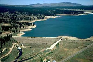
Boca Dam is an earthfill dam and a part of the Truckee Storage Project that encompasses Nevada County, California and Washoe County, Nevada in the United States. Open year-round, it is located at the southern end of Boca Reservoir, 1 mi (2 km) north of Interstate 80, 0.3 mi (480 m) above the confluence of the Little Truckee River and the Truckee River, and 6 mi (9.7 km) northeast of Truckee, California. Reno, Nevada lies 27 mi (43 km) to the east.

Peavine Peak, the highest point on Peavine mountain, is located in Washoe County Nevada, at the northwest corner of the Truckee Meadows and about 3.5 miles (5.6 km) due east of the California state. It forms one of the most dominant geographical features in the Reno/Sparks area. Early prospectors to the mountain discovered wild pea vines growing in the vicinity of Peavine Springs on the northeast flank of the mountain, near Poeville, hence the name.
Truckee Meadows Water Authority (TMWA) is a public authority providing water services in the Truckee Meadows of Washoe County in Northern Nevada, which serves more than 330,000 residents. The Authority is governed by a seven-member Board of Directors, appointed by the cities of Reno and Sparks and Washoe County.
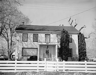
The Peleg Brown Ranch, at 12945 Old Virginia Rd. in Reno, Nevada, dates from 1864. Also known as the Louis Damonte Ranch, it includes Bungalow/craftsman and Greek Revival architecture. It was listed on the National Register of Historic Places in 1994; the listing included five contributing buildings on about 4 acres (1.6 ha).

Ophir Creek is a 7.7-mile (12.4 km) eastward-flowing stream originating in Tahoe Meadows just south of Tamarack Peak and southeast of Mount Rose Summit, a pass on Nevada State Highway 431. Ophir Creek flows to Washoe Lake in Washoe County in western Nevada, shortly after passing under U.S. Route 395.
For over two decades in the early twentieth century, there existed a network of streetcars in Reno that served as the main mode of public transit in Reno, Nevada, United States. The system consisted of a streetcar network in the area of Reno and Sparks, Nevada, as well as an interurban line between Reno and the Moana Springs resort.

The Truckee Meadows Fire Protection District of Washoe County Nevada covers the eastern slopes of the Sierra Nevada Mountains in Western Nevada. The county spans an area of nearly 6,600 square miles in the northwest section of the state bordering California and Oregon. TMFPD was originally founded in 1972 and operated independently until 2001. Washoe County contracted the City of Reno Fire Dept. to operate TMFPD engines until 2012. Early in 2012 the agreement with the City of Reno was terminated and TMFPD was stood back up and operated independently again. The Truckee Meadows Fire Protection District operates a fire apparatus fleet of 10 engines, 1 ladder company, 11 brush trucks, 1 rescue squad, 1 ambulance, 1 hazardous material unit, various support units, 2 technical rescue support units, 9 water tenders, and 2 water rescue entry vehicles The District's primary areas of responsibility include rural and suburban communities outside the City of Reno. Truckee Meadows Fire Protection District responded to 10,581 calls for service with a 2017/2018 budget of $27,932,275.
