
The Truckee River is a river in the U.S. states of California and Nevada. The river flows northeasterly and is 121 miles (195 km) long. The Truckee is the sole outlet of Lake Tahoe and drains part of the high Sierra Nevada, emptying into Pyramid Lake in the Great Basin. Its waters are an important source of irrigation along its valley and adjacent valleys.
Shasta Lake, also popularly known as Lake Shasta, is a reservoir in Shasta County, California, United States. It began to store water in 1944 due to the impounding of the Sacramento River by Shasta Dam, the ninth tallest dam in the United States.
Casitas Dam is an earthfill dam across Coyote Creek that forms Lake Casitas in Ventura County, California near Oak View, California. The dam is located two miles (3 km) above the junction of Coyote Creek and the Ventura River. Water from the Ventura River is diverted to Lake Casitas as well. The 334 ft (102 m) structure was built by the U.S. Bureau of Reclamation. It is a key part of the Ventura River Project. Construction was completed in 1959 and was strengthened in June–December 2000 as a seismic improvement to help withstand earthquakes greater than 6.5. Lake Casitas has a 254,000 acre⋅ft (313,000,000 m3) storage capacity and provides irrigation and municipal uses for the Casitas Municipal Water District.

The Little Truckee River is a 34.3-mile-long (55.2 km) river that is a tributary to its larger counterpart, the Truckee River, north of Lake Tahoe. It drains the eastern flank of the Sierra Nevada, flowing through Sierra County and Nevada County in eastern California.

The San Luis Reservoir is an artificial lake on San Luis Creek in the eastern slopes of the Diablo Range of Merced County, California, approximately 12 mi (19 km) west of Los Banos on State Route 152, which crosses Pacheco Pass and runs along its north shore. It is the fifth largest reservoir in California. The reservoir stores water taken from the San Joaquin-Sacramento River Delta. Water is pumped uphill into the reservoir from the O'Neill Forebay which is fed by the California Aqueduct and is released back into the forebay to continue downstream along the aqueduct as needed for farm irrigation and other uses. Depending on water levels, the reservoir is approximately nine miles (14 km) long from north to south at its longest point, and five miles (8 km) wide. At the eastern end of the reservoir is the San Luis Dam, the fourth largest embankment dam in the United States, which allows for a total capacity of 2,041,000 acre-feet (2,518,000 dam3). Pacheco State Park lies along its western shores.

Mammoth Pool Reservoir is a reservoir on the San Joaquin River in the Sierra Nevada, within the Sierra National Forest in California. It creates the border between Fresno County and Madera County. It is about 45 miles (72 km) north-northeast of Fresno.

Bouquet Reservoir is an artificial lake in the Angeles National Forest of Los Angeles County, California about 15 miles (24 km) west from Palmdale.
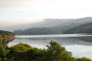
Crystal Springs Reservoir is a pair of artificial lakes located in the northern Santa Cruz Mountains of San Mateo County, California, situated in the rift valley created by the San Andreas Fault just to the west of the cities of San Mateo and Hillsborough, and I-280. The lakes are part of the San Mateo Creek watershed. Crystal Springs Regional Trail runs along the reservoir.
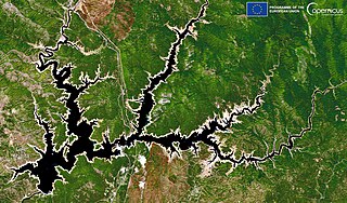
Boca Dam is an earthfill dam and a part of the Truckee Storage Project that encompasses Nevada County, California and Washoe County, Nevada in the United States. Open year-round, it is located at the southern end of Boca Reservoir, 1 mi (2 km) north of Interstate 80, 0.3 mi (480 m) above the confluence of the Little Truckee River and the Truckee River, and 6 mi (9.7 km) northeast of Truckee, California. Reno, Nevada lies 27 mi (43 km) to the east.
Boca is a former settlement in Nevada County, California. Situated at an elevation of 5,528 ft (1,685 m) above sea level, Boca is located on the Southern Pacific Railroad, 6.5 miles (10.5 km) northeast of Truckee.
Iceland, once known as Cuba, was an ice farming and lumbering community in eastern Nevada County, California. It was located between Boca, California and the Nevada state line, about 1 1/2 miles south of Floriston, California and 9 miles east of Truckee, California. It lay near where Gray Creek flows into the Truckee River.
San Vicente Reservoir is a reservoir created by the San Vicente Dam in San Diego County, California. It is located in the Cuyamaca Mountains, approximately 4.3 miles (6.9 km) north of Lakeside off California State Route 67.

Martis Valley is a geographic area of 70 square miles (180 km2) in the United States, extending northward from the North Shore of Lake Tahoe, California, to the west of the California-Nevada border. It is located in Placer and Nevada Counties and is bisected by Martis Creek which flows north to the Truckee River.

Martis Creek is a northward-flowing stream originating on Sawtooth Ridge, west of the peak of Mount Pluto in Placer County, California, United States. After crossing into Nevada County, California, it is a tributary to the Truckee River on the eastern side of Truckee.

Prosser Creek is a perennial stream in Nevada County, California, formed from the North Fork Prosser Creek and South Fork Prosser Creek, then flowing into Prosser Creek Reservoir, and then to the Truckee River.

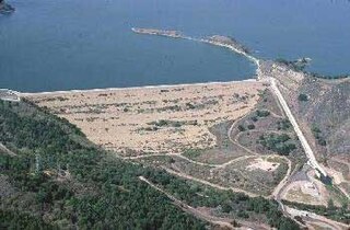
Prosser Creek Dam is a dam in Nevada County, California.

Lake Tahoe Dam is a concrete gravity dam on the Truckee River, at the outlet of Lake Tahoe in Placer County, California.

Flooding in 2017 affected parts of California in the first half of the year. Northern California saw its wettest winter in almost a century, breaking the record set in 1982–83. The same storm systems also flooded parts of western Nevada and southern Oregon. The damage was estimated at $1.55 billion ($1,926,663,046 today), including damage to California roads and highways estimated at more than $1.05 billion.


