Rabaul caldera

Last updated
Rabaul caldera
Rabaul caldera from space.png
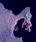
True-colour image of the Rabaul caldera from space. From left to right: Vulcan (twin cones), Rabalanakaia, Tavurvur.
Highest point
Elevation 688 m (2,257 ft) [1]
Listing List of volcanoes in Papua New Guinea
Coordinates 4°16′16″S152°12′11″E / 4.27111°S 152.20306°E / -4.27111; 152.20306 [1]
Geography
Geology
Age of rock ~1,400 years
Mountain type Pyroclastic shield/Caldera
Volcanic arc/belt Bismarck volcanic arc
Last eruption August to September 2014 [1]

The Rabaul caldera, or Rabaul Volcano, is a large volcano on the tip of the Gazelle Peninsula in East New Britain, Papua New Guinea, and derives its name from the town of Rabaul inside the caldera. The caldera has many sub-vents, Tavurvur being the most well known for its devastating eruptions over Rabaul. The outer flanks of the highest peak, a 688-metre-high asymmetrical pyroclastic shield, are formed by thick pyroclastic flow deposits. [1] There is no sign of a pyroclastic shield along the rim of the caldera, making the location likely underwater, on the caldera's floor.

Contents

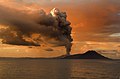
Tavurvur, a stratovolcano and a sub-vent of the caldera, is the most visibly active, continuously throwing ash. In 1994 it, and nearby Vulcan, erupted and devastated Rabaul; however, due to planning for such a catastrophe, the townsfolk were prepared and only five people were killed. One of the deaths was caused by lightning, a feature of volcanic ash clouds. [2] [3] [4]

In 1937, Vulcan and Tavurvur erupted simultaneously, killing 507 people. This event led to the founding of the Rabaul Volcano Observatory, which watches over the many active volcanoes in Papua New Guinea. [5] One eruption over several days in March 2008 released a plume of ash and water vapor that drifted northwest over the Bismarck Sea. [6]

Subsidiary features

Eruptions


July 2010 eruptions

After this eruption, GPS data showed deflation of Tavurvur cone. Seismicity was very low, and diffuse white plumes were emitted during 26–30 July. [11]

2013–14 eruptions

Related Research Articles

<span class="mw-page-title-main">Volcano</span> Rupture in the crust of a planet that allows lava, ash, and gases to escape from below the surface

A volcano is a rupture in the crust of a planetary-mass object, such as Earth, that allows hot lava, volcanic ash, and gases to escape from a magma chamber below the surface.

<span class="mw-page-title-main">Mount Vesuvius</span> Active stratovolcano in the Gulf of Naples, Italy

Mount Vesuvius is a somma-stratovolcano located on the Gulf of Naples in Campania, Italy, about 9 km (5.6 mi) east of Naples and a short distance from the shore. It is one of several volcanoes forming the Campanian volcanic arc. Vesuvius consists of a large cone partially encircled by the steep rim of a summit caldera, resulting from the collapse of an earlier, much higher structure.

<span class="mw-page-title-main">Nevado del Ruiz</span> Volcanic mountain in Colombia

Nevado del Ruiz, also known as La Mesa de Herveo is a volcano on the border of the departments of Caldas and Tolima in Colombia, about 129 km (80 mi) west of the capital city Bogotá. It is a stratovolcano composed of many layers of lava alternating with hardened volcanic ash and other pyroclastic rocks. Volcanic activity at Nevado del Ruiz began about two million years ago, since the Early Pleistocene or Late Pliocene, with three major eruptive periods. The current volcanic cone formed during the present eruptive period, which began 150,000 years ago.

<span class="mw-page-title-main">Rabaul</span> Township in East New Britain, Papua New Guinea

Rabaul is a township in the East New Britain province of Papua New Guinea, on the island of New Britain. It lies about 600 kilometres to the east of the island of New Guinea. Rabaul was the provincial capital and most important settlement in the province until it was destroyed in 1994 by falling ash from a volcanic eruption in its harbour. During the eruption, ash was sent thousands of metres into the air, and the subsequent rain of ash caused 80% of the buildings in Rabaul to collapse. After the eruption the capital was moved to Kokopo, about 20 kilometres (12 mi) away. Rabaul is continually threatened by volcanic activity, because it is on the edge of the Rabaul caldera, a flooded caldera of a large pyroclastic shield.

<span class="mw-page-title-main">Mount Katmai</span> Stratovolcano in Katmai National Park, Alaska, USA

Mount Katmai is a large active stratovolcano on the Alaska Peninsula in southern Alaska, located within Katmai National Park and Preserve. It is about 6.3 miles (10 km) in diameter with a central lake-filled caldera about two by three miles in size, formed during the Novarupta eruption of 1912. The caldera rim reaches a maximum elevation of 6,716 feet (2,047 m). In 1975 the surface of the crater lake was at an elevation of about 4,220 feet (1,286 m), and the estimated elevation of the caldera floor is about 3,400 ft (1,040 m). The mountain is located in Kodiak Island Borough, very close to its border with Lake and Peninsula Borough. The volcano has caused ten known fatalities due to gas exposure.

<span class="mw-page-title-main">Volcán de Colima</span> Volcano in Mexico

The Volcán de Colima, 3,820 m (12,530 ft), also known as Volcán de Fuego, is part of the Colima Volcanic Complex (CVC) consisting of Volcán de Colima, Nevado de Colima and the eroded El Cántaro. It is the youngest of the three and as of 2015 is one of the most active volcanoes in Mexico and in North America. It has erupted more than 40 times since 1576. One of the largest eruptions was on January 20–24, 1913. Nevado de Colima, also known as Tzapotépetl, lies 5 kilometres (3.1 mi) north of its more active neighbor and is the taller of the two at 4,271 meters. It is the 26th-most prominent peak in North America.

<span class="mw-page-title-main">Tavurvur</span> Active stratovolcano near Rabaul, on the island of New Britain, in Papua New Guinea

Tavurvur is an active stratovolcano near Rabaul, on the island of New Britain, in Papua New Guinea. It is a sub-vent of the Rabaul caldera and lies on the eastern rim of the larger feature. An eruption of the volcano largely destroyed the nearby town of Rabaul in 1994.

<span class="mw-page-title-main">Mount Redoubt</span> Volcanic cone in the United States

Redoubt Volcano, or Mount Redoubt, is an active stratovolcano in the largely volcanic Aleutian Range of the U.S. state of Alaska. Located at the head of the Chigmit Mountains subrange in Lake Clark National Park and Preserve, the mountain is just west of Cook Inlet, in the Kenai Peninsula Borough about 110 miles (180 km) southwest of Anchorage. At 10,197 feet (3,108 m), in just over 5 miles (8.0 km) Mount Redoubt attains 9,150 feet (2,790 m) of prominence over its surrounding terrain. It is the highest summit in the Aleutian Range. In 1976, Redoubt Volcano was designated as a National Natural Landmark by the National Park Service.

<span class="mw-page-title-main">Mount Rinjani</span> Volcano in Lombok, Indonesia

Mount Rinjani is an active volcano in Indonesia on the island of Lombok. Administratively the mountain is in the Regency of North Lombok, West Nusa Tenggara. It rises to 3,726 metres (12,224 ft), making it the second highest volcano in Indonesia. It is also the highest point in the Indonesian province of West Nusa Tenggara.

<span class="mw-page-title-main">Mount Okmok</span>

Mount Okmok is the highest point on the rim of Okmok Caldera on the northeastern part of Umnak Island in the eastern Aleutian Islands of Alaska. This 9.3 kilometers (5.8 mi) wide circular caldera truncates the top of a large shield volcano. The volcano is currently rated by the Alaska Volcano Observatory as Aviation Alert Level Green and Volcanic-alert Level Normal.

<span class="mw-page-title-main">Mount Cleveland (Alaska)</span> Nearly symmetrical stratovolcano on Chuginadak island

Mount Cleveland is a nearly symmetrical stratovolcano on the western end of Chuginadak Island, which is part of the Islands of Four Mountains just west of Umnak Island in the Fox Islands of the Aleutian Islands of Alaska. Mt. Cleveland is 5,675 ft (1,730 m) high, and one of the most active of the 75 or more volcanoes in the larger Aleutian Arc. Aleutian natives named the island after their fire goddess, Chuginadak, who they believed inhabited the volcano. In 1894 a team from the U.S. Coast and Geodetic Survey visited the island and gave Mount Cleveland its current name, after then-president Grover Cleveland.

<span class="mw-page-title-main">Cerro Azul (Chile volcano)</span> Mountain in Curicó Province, Chile

Cerro Azul, sometimes referred to as Quizapu, is an active stratovolcano in the Maule Region of central Chile, immediately south of Descabezado Grande. Part of the South Volcanic Zone of the Andes, its summit is 3,788 meters (12,428 ft) above sea level, and is capped by a summit crater that is 500 meters (1,600 ft) wide and opens to the north. Beneath the summit, the volcano features numerous scoria cones and flank vents.

<span class="mw-page-title-main">Reventador</span>

Reventador is an active stratovolcano which lies in the eastern Andes of Ecuador. It lies in a remote area of the national park of the same name, which is Spanish for "exploder". Since 1541, it has erupted over 25 times, although its isolated location means that many of its eruptions have gone unreported.

<span class="mw-page-title-main">Mount Bulusan</span> Volcano in the Philippines

Mount Bulusan, also known as Bulusan Volcano, is a stratovolcano on the island of Luzon in the Philippines. Located in the province of Sorsogon in the Bicol Region, it is 70 kilometres (43 mi) southeast of Mayon Volcano and approximately 390 kilometres (240 mi) southeast of the Philippine capital of Manila.

<span class="mw-page-title-main">Lake Ilopango</span> Crater lake in El Salvador which fills a caldera

Lake Ilopango is a crater lake which fills an 8 by 11 km volcanic caldera in central El Salvador, on the borders of the San Salvador, La Paz, and Cuscatlán departments. The caldera, which contains the second largest lake in the country and is immediately east of the capital city, San Salvador, has a scalloped 100 m (330 ft) to 500 m (1,600 ft) high rim. Any surplus drains via the Jiboa River to the Pacific Ocean. The local military airbase, Ilopango International Airport, has annual airshows where international pilots from all over the world fly over San Salvador City and Ilopango lake.

<span class="mw-page-title-main">Types of volcanic eruptions</span> Overview of different types of volcanic eruptions

Several types of volcanic eruptions—during which lava, tephra, and assorted gases are expelled from a volcanic vent or fissure—have been distinguished by volcanologists. These are often named after famous volcanoes where that type of behavior has been observed. Some volcanoes may exhibit only one characteristic type of eruption during a period of activity, while others may display an entire sequence of types all in one eruptive series.

<span class="mw-page-title-main">Chaitén (volcano)</span> Active volcano in Palena Province, Los Lagos Region, Chile

Chaitén is a volcanic caldera 3 kilometres (2 mi) in diameter, 17 kilometres (11 mi) west of the elongated ice-capped Michinmahuida volcano and 10 kilometres (6 mi) northeast of the town of Chaitén, near the Gulf of Corcovado in southern Chile. The most recent eruptive phase of the volcano erupted on 2008. Originally, radiocarbon dating of older tephra from the volcano suggested that its last previous eruption was in 7420 BC ± 75 years. However, recent studies have found that the volcano is more active than thought. According to the Global Volcanism Program, its last eruption was in 2011.

<span class="mw-page-title-main">Mount Gareloi</span> Stratovolcano in the Aleutian Islands of Alaska, U.S.

Mount Gareloi, or Gareloi Volcano, is a stratovolcano in the Aleutian Islands of Alaska, United States, about 1,259 miles (2,026 km) from Anchorage. Gareloi is located on Gareloi Island, and comprises most of its land mass. The island also has two small glaciers which protrude to the northwest and southeast.

<span class="mw-page-title-main">San Martin Tuxtla</span>

The isolated San Martin Tuxtla volcano is a shield volcano which rises above the Gulf of Mexico. It has had eruptions in historical times. It occurs in the Tuxtla volcanic field in Veracruz, Mexico. Lavas from San Martin vary between basanite and alkali basalt. Locally the volcano is also known as Tiltépetl.

<span class="mw-page-title-main">Aso Caldera</span> Caldera in Kumamoto Prefecture, Japan

Aso caldera is a geographical feature of Kumamoto Prefecture, Japan. It stretches 25 kilometers north to south and 18 kilometers east to west. The central core "Aso Gogaku" is the five major mountains in the area. Aso valley (Asodani) runs along the northern base of Mount Aso and Nango valley (Nangodani) along the south. According to research of caldera sediment, lakes used to exist in these valleys. The dried up lake areas have come to be called Old Aso Lake, Kugino Lake, and Aso Valley Lake. The Kikuchi, Shirakawa and Kurokawa rivers now drain the caldera.

References

  1. 1 2 3 4 5 "Rabaul". Global Volcanism Program . Smithsonian Institution . Retrieved 2020-03-26.
  2. Simons, Paul (May 8, 2008). "Dirty thunderstorm shoots lightning from volcano" . London: Times Online. Retrieved 2009-01-09.
  3. Perkins, Sid (March 4, 2015). "Flash glass: Lightning inside volcanic ash plumes create glassy spherules". American Association for the Advancement of Science.
  4. Sample, Ian (3 December 2015). "Sky lights up over Sicily as Mount Etna's Voragine crater erupts". the Guardian. Retrieved 2015-12-03.
  5. Smithsonian Institution / SEAN (1989). Lindsay McClelland; Tom Simkin; Marjorie Summers; Elizabeth Nielsen; Thomas C. Stein (eds.). Global Volcanism 1975–1985. Prentice Hall, Englewood Cliffs NJ, and American Geophysical Union, Washington DC. pp.  180–189. ISBN   0-13-357203-X.
  6. "Rabaul Volcano, New Britain". NASA Earth Observatory. Archived from the original on 28 March 2008. Retrieved 20 March 2008.
  7. "Global Volcanism Program | Rabaul".
  8. 1 2 "Rabaul". 2 August 2011.
  9. "The Rabaul Eruption". USGS. 1994-09-23. Retrieved 2016-03-05.
  10. "Winds soften erupting volcano's impact". Online News. Australian Broadcasting Corporation. 8 October 2006. Archived from the original on 2008-04-20.
  11. "09/2010 (BGVN 35:09) After Months of Quiet, Ash-Bearing Eruptions on 23–25 July 2010". www.volcano.si.edu. September 2010. Retrieved 2011-10-05.
  12. "Global Volcanism Program | Rabaul".
  13. "PNG volcano Tavurvur eruption may disrupt Australian flights". news.com.au. 2014-08-29. Retrieved 2014-08-29.
  14. "Papua New Guinea's Tavurvur Volcano Erupts; Locals Evacuate, Flights Disrupted". abcnews.go.com. 2014-08-29. Retrieved 2014-08-29.

Images