Related Research Articles
A caldera is a large cauldron-like hollow that forms shortly after the emptying of a magma chamber in a volcanic eruption. An eruption that ejects large volumes of magma over a short period of time can cause significant detriment to the structural integrity of such a chamber, greatly diminishing its capacity to support its own roof, and any substrate or rock resting above. The ground surface then collapses into the emptied or partially emptied magma chamber, leaving a large depression at the surface. Although sometimes described as a crater, the feature is actually a type of sinkhole, as it is formed through subsidence and collapse rather than an explosion or impact. Compared to the thousands of volcanic eruptions that occur over the course of a century, the formation of a caldera is a rare event, occurring only a few times within a given window of 100 years. Only eight caldera-forming collapses are known to have occurred between 1911 and 2018, with a caldera collapse at Kīlauea, Hawaii in 2018. Volcanoes that have formed a caldera are sometimes described as "caldera volcanoes".
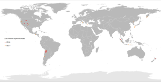
A supervolcano is a volcano that has had an eruption with a volcanic explosivity index (VEI) of 8, the largest recorded value on the index. This means the volume of deposits for such an eruption is greater than 1,000 cubic kilometers.
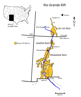
The Rio Grande rift is a north-trending continental rift zone. It separates the Colorado Plateau in the west from the interior of the North American craton on the east. The rift extends from central Colorado in the north to the state of Chihuahua, Mexico, in the south. The rift zone consists of four basins that have an average width of 50 kilometres (31 mi). The rift can be observed on location at Rio Grande National Forest, White Sands National Park, Santa Fe National Forest, and Cibola National Forest, among other locations.

The Taupō Volcanic Zone (TVZ) is a volcanic area in the North Island of New Zealand that has been active for at least the past two million years and is still highly active. Mount Ruapehu marks its south-western end and the zone runs north-eastward through the Taupō and Rotorua areas and offshore into the Bay of Plenty. It is part of a larger Central Volcanic Region that extends to the Coromandel Peninsula and has been active for four million years. The zone is contained within the tectonic intra-arc continental Taupō Rift and this rift volcanic zone is widening unevenly east–west with the greatest rate of widening at the Bay of Plenty coast, the least at Mount Ruapehu and a rate of about 8 mm (0.31 in) per year at Taupō. The zone is named after Lake Taupō, the flooded caldera of the largest volcano in the zone, the Taupō Volcano and contains a large central volcanic plateau as well as other landforms.

The Yellowstone hotspot is a volcanic hotspot in the United States responsible for large scale volcanism in Idaho, Montana, Nevada, Oregon, and Wyoming, formed as the North American tectonic plate moved over it. It formed the eastern Snake River Plain through a succession of caldera-forming eruptions. The resulting calderas include the Island Park Caldera, Henry's Fork Caldera, and the Bruneau-Jarbidge caldera. The hotspot currently lies under the Yellowstone Caldera. The hotspot's most recent caldera-forming supereruption, known as the Lava Creek Eruption, took place 640,000 years ago and created the Lava Creek Tuff, and the most recent Yellowstone Caldera. The Yellowstone hotspot is one of a few volcanic hotspots underlying the North American tectonic plate; another example is the Anahim hotspot.

La Garita Caldera is a large caldera and extinct supervolcano in the San Juan volcanic field in the San Juan Mountains around the town of Creede in southwestern Colorado, United States. It is west of La Garita, Colorado. The eruption that created the La Garita Caldera is among the largest known volcanic eruptions in Earth's history, as well as being one of the most powerful known supervolcanic events.

The Boot Heel volcanic field is located in the Bootheel region of southwest New Mexico, adjacent areas of southeastern Arizona, and northwest Mexico. The field covers an area of more than 24,000 km2. The field includes nine volcanic calderas ranging in age from 26.9 to 35.3 Ma. Extrusive products include rhyolitic ignimbrites along with basalt, andesite, and rhyolite lava flows. The major ash flow tuff sheets produced, range in volume from 35 to 650 km3.

This timeline of volcanism on Earth includes a list of major volcanic eruptions of approximately at least magnitude 6 on the Volcanic explosivity index (VEI) or equivalent sulfur dioxide emission during the Quaternary period. Other volcanic eruptions are also listed.
The San Juan volcanic field is part of the San Juan Mountains in southwestern Colorado. It consists mainly of volcanic rocks that form the largest remnant of a major composite volcanic field that covered most of the southern Rocky Mountains in the Middle Tertiary geologic time. There are approximately fifteen calderas known in the San Juan Volcanic Fields; however, it is possible that there are two or even three more in the region.
The Mogollon-Datil volcanic field is a large silicic volcanic field in western New Mexico. It is a part of an extensive Eocene to Oligocene volcanic event which includes the San Juan volcanic field in southwestern Colorado, the Trans-Pecos volcanic field in west Texas and north central Mexico, the Boot Heel volcanic field in the bootheel of southwestern New Mexico and adjacent areas of Arizona and Mexico; and the vast volcanic field of the Sierra Madre Occidental of western Mexico. The Mogollon-Datil volcanic field was formed in "four discrete pulses representing synchronized activity of two separate cauldron complexes".
The Fish Canyon Tuff is the large volcanic ash flow or ignimbrite deposit resulting from one of the largest known explosive eruptions on Earth, estimated at 1,200 cu mi (5,000 km3). (see List of largest volcanic eruptions). The Fish Canyon Tuff eruption was centred at the La Garita Caldera in southwest Colorado; the caldera itself would have formed by collapse, as a result of the eruption. Studies of the tuff show that it all belongs to one eruption due to its uniform bulk-chemical composition (SiO2=bulk 67.5–68.5% (dacite), matrix 75–76% (rhyolite) and consistent phenocryst content (35–50%) and mineralogical composition (plagioclase, sanidine, quartz, biotite, hornblende, sphene, apatite, zircon, Fe-Ti oxides are the primary phenocrysts). This tuff and eruption is part of the larger San Juan volcanic field and the Oligocene Southern Rocky Mountain ignimbrite flare-up.
The Mid-Tertiary ignimbrite flare-up, was a dramatic period of volcanic eruptions in mid-Cenozoic time, approximately 25–40 million years ago, centered in the western United States. These eruptions are seen today as deposits of ignimbrite, the pyroclastic material that was laid down from these eruptions.
Calabozos is a Holocene caldera in central Chile's Maule Region. Part of the Chilean Andes' volcanic segment, it is considered a member of the Southern Volcanic Zone (SVZ), one of the three distinct volcanic belts of South America. This most active section of the Andes runs along central Chile's western edge, and includes more than 70 of Chile's stratovolcanoes and volcanic fields. Calabozos lies in an extremely remote area of poorly glaciated mountains.

The Altiplano–Puna volcanic complex, also known as APVC, is a complex of volcanic systems in the Puna of the Andes. It is located in the Altiplano area, a highland bounded by the Bolivian Cordillera Real in the east and by the main chain of the Andes, the Western Cordillera, in the west. It results from the subduction of the Nazca Plate beneath the South American Plate. Melts caused by subduction have generated the volcanoes of the Andean Volcanic Belt including the APVC. The volcanic province is located between 21° S–24° S latitude. The APVC spans the countries of Argentina, Bolivia and Chile.

La Reforma is a Plio-Pleistocene caldera on the Baja California Peninsula in Mexico. It is part of eleven volcanoes in Baja California, which formed with the Gulf of California during the Miocene, about ten million years ago. Previously, a volcanic arc had existed on the peninsula. The caldera's basement consists of granites and monzonites, formed between the Cretaceous and the Middle Miocene.
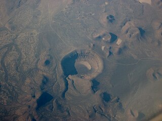
Lunar Crater volcanic field is a volcanic field in Nye County, Nevada. It lies along the Reveille and Pancake Ranges and consists of over 200 vents, mostly small volcanic cones with associated lava flows but also several maars, including one maar named Lunar Crater. Some vents have been eroded so heavily that the structures underneath the volcanoes have been exposed. Lunar Crater itself has been used as a testing ground for Mars rovers and as training ground for astronauts.

The Bandelier Tuff is a geologic formation exposed in and around the Jemez Mountains of northern New Mexico. It has a radiometric age of 1.85 to 1.25 million years, corresponding to the Pleistocene epoch. The tuff was erupted in a series of at least three caldera eruptions in the central Jemez Mountains.

The Amalia Tuff is a geologic formation exposed in and around Questa, New Mexico. It has a radiometric age of 25.39 ± 0.04 million years, corresponding to the Oligocene epoch.
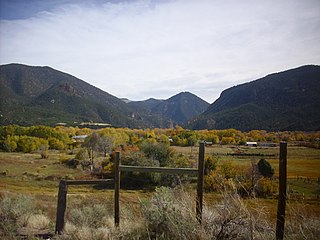
The Latir volcanic field is a large volcanic field near Questa, New Mexico, that was active during the late Oligocene to early Miocene, 28 to 22 million years ago (Ma). It includes the Questa caldera, in whose deeply eroded interior is located the Molycorp Questa molybdenum mine.
References
- ↑ Smith, R.L. and Luedke, R.G. (1984).
- ↑ McKee, E. H. (1971).
- ↑ "Northwest Origins, An Introduction to the Geologic History of Washington State, Catherine L. Townsend and John T. Figge". The Burke Museum of Natural History and Culture, University of Washington. Retrieved 2010-04-10.
- ↑ "Oregon: A Geologic History". Oregon Department of Geology and Mineral Industries. Archived from the original on 2010-01-28. Retrieved 2010-03-26.
- ↑ "Digital Geology of Idaho, Laura DeGrey and Paul Link". Idaho State University. Retrieved 2010-04-10.
- ↑ Chapin, C.E.; Wilks, M. and McIntosh, W.C. (2004).
- ↑ Hildreth, W. (1979), Sarna-Wojcicki et al. (2000).
- 1 2 3 4 5 6 7 8 9 10 11 12 13 14 15 16 17 18 19 20 21 22 23 24 25 26 27 28 29 30 31 32 33 34 35 36 37 38 39 40 41 42 43 44 45 46 47 48 49 50 51 52 53 54 55 56 57 58 59 60 61 62 63 64 65 66 67 68 69 Supplementary Table to P.L. Ward (2009).
- 1 2 Izett, Glen A. (1981).
- ↑ Heiken et al. (1990).
- ↑ Min et al. (2004).
- ↑ Valles Caldera
- ↑ Rytuba, James J. et al. (2004).
- ↑ Matthew A. Coble, and Gail A. Mahood (2008).
- ↑ Noble, D.C. (1988).
- ↑ Castor, S.B., and Henry, C.D. (2000).
- ↑ Korringa, Marjorie K. (1973).
- ↑ Matthew E. Brueseke and William K. Hart (2008).
- 1 2 "High Lava Plains Project, Geophysical & Geological Investigation, Understanding the Causes of Continental Intraplate Tectonomagmatism: A Case Study in the Pacific Northwest". Department of Terrestrial Magnetism, Carnegie Institution of Washington. Archived from the original on 2010-06-18. Retrieved 2010-03-26.
- ↑ Tolan, T.L.; Reidel, S.P.; Beeson, M.H.; Anderson, J.L.; Fecht, K.R. & Swanson, D.A. (1989), "Revisions to the estimates of the areal extent and volume of the Columbia River Basalt Group", in Reidel, S.P. & Hooper, P.R. (eds.), Volcanism and tectonism in the Columbia River flood basalt province Spec. Paper, vol. 239, Geol. Soc. Amer., pp. 1–20
- ↑ Camp, V.E. & Ross, M.E. (2004). "Mantle dynamics and genesis of mafic magmatism in the intermontane Pacific Northwest". Journal of Geophysical Research. 109 (B08204). Bibcode:2004JGRB..109.8204C. doi: 10.1029/2003JB002838 .
- ↑ Carlson, R.W. & Hart, W.K. (1987). "Crustal Genesis on the Oregon Plateau". J. Geophys. Res. 92 (B7): 6191–6206. Bibcode:1987JGR....92.6191C. doi:10.1029/JB092iB07p06191.
- ↑ Hart, W.K. & Carlson, R.W. (1985). "Distribution and geochronology of Steens Mountain-type basalts from the northwestern Great Basin". Isochron/West. 43: 5–10.
- 1 2 3 4 5 6 7 8 9 10 11 Lipman (1984).
- 1 2 3 Lipman (1976).
- ↑ Hon and Lipman (1976).
- ↑ "Volcanic Past Arizona". USGS. Archived from the original on 2010-06-16. Retrieved 2010-03-30.
- 1 2 3 4 5 6 7 8 9 10 Lipman (2000).
- 1 2 3 4 5 Manson et al. (2004).
- ↑ Largest explosive eruptions: New results for the 27.8 Ma Fish Canyon Tuff and the La Garita caldera, San Juan volcanic field, Colorado Archived 2011-05-19 at the Wayback Machine
- ↑ Bachmann et al. (2002).
- 1 2 Lipman et al. (1973).
- ↑ Steven and Lipman (1976).
- 1 2 3 4 Sawyer et al. (1984).
- 1 2 Ratté et al. (1984).
- 1 2 3 Lipman (1975).
- 1 2 Lipman et al. (1996).
- ↑ Maughan (2002).
- ↑ Best et al. (1989).
- 1 2 Seager (1973).
- ↑ Best (1993).
- ↑ Lipman and McIntosh (2008).
- ↑ Henry and Price (1984).
- 1 2 Lipman and Calvert (2003).
- 1 2 Erb (1979).
- ↑ Breining, Greg (2007). "Most-Super Volcanoes" . Super Volcano: The Ticking Time Bomb Beneath Yellowstone National Park. St. Paul, MN: Voyageur Press. p. 256. ISBN 978-0-7603-2925-2.
- ↑ "Gila Wilderness Site". City of Rocks State Park. Retrieved 2010-05-15.
- ↑ Elston et al. (1975).
- ↑ "Gila Cliff Dwellings National Monument". New Mexico Bureau of Geology & Mineral Resources. Retrieved 2010-05-15.
- ↑ Osburn and Chapin (1983).
- ↑ Gregory and McIntosh (1996).
- 1 2 McIntosh and Chapin (2004).
- ↑ "Online guide to the continental Cretaceous-Tertiary boundary in the Raton basin, Colorado and New Mexico, Description of the Route from Denver to Raton". USGS. Retrieved 2010-03-30.
- 1 2 3 4 5 6 Henry et al. (1994).
- ↑ Deal et al. (1978).
- ↑ Hardyman (1981).
- ↑ Moye et al. (1988).
- ↑ Sawyer and Lipman (1983).
- ↑ "Geologic Setting – How the Tucson Valley and Surrounding Mountains Formed". Pima Community College. Retrieved 2010-05-15.