Related Research Articles

The Rio Grande in the United States or the Río Bravo in Mexico is one of the principal rivers in the southwestern United States and in northern Mexico. The length of the Rio Grande is 1,896 miles (3,051 km), making it the 4th longest river in North America by main stem. It originates in south-central Colorado, in the United States, and flows to the Gulf of Mexico. The Rio Grande drainage basin (watershed) has an area of 182,200 square miles (472,000 km2); however, the endorheic basins that are adjacent to and within the greater drainage basin of the Rio Grande increase the total drainage-basin area to 336,000 square miles (870,000 km2).

Blades is a town in Sussex County, Delaware, United States. As of the 2010 census, the town population was 1,241, a 29.8% increase over the previous decade. It is part of the Salisbury, Maryland-Delaware Metropolitan Statistical Area.

Kapalua is a census-designated place (CDP) in Maui County, Hawaiʻi, United States. A resort development by the Maui Land & Pineapple Company extends inland from Kapalua Bay and Honolua Bay. The population was 495 at the 2020 census.

The Province of Teramo is a province in the Abruzzo region of Italy. Its capital is the city of Teramo. The province has an area of 1,948 square kilometres (752 sq mi), a population of 313,029 (2012), and is subdivided into 47 comunes, see Comunes of the Province of Teramo. The Province of Teramo shares its northern border with the Province of Ascoli Piceno in the Marche Region, southern and southwestern borders with the Province of L'Aquila in the Abruzzo Region, and a western border with the Province of Rieti in the Region of Lazio. To the south is the Abruzzo Province of Pescara and to the east is the Adriatic Sea.

North Park is a high, sparsely populated basin in the Rocky Mountains in north central Colorado in the United States. It encompasses a wide valley in Jackson County rimmed by mountain ranges at the headwaters of the North Platte River and several smaller tributaries, including the Michigan River, Illinois River, and Canadian River. The valley receives its name from being the northernmost of the three large mountain valleys in Colorado on the western side of the Front Range. The others are Middle Park and South Park respectively.

The Great Divide Basin or Great Divide Closed Basin is an area of land in the Red Desert of Wyoming where none of the water falling as rain to the ground drains into any ocean, directly or indirectly. It is thus an endorheic basin, one of several in the United States that adjoin the Continental Divide. To the south and west of the basin is the Green River watershed, draining to the Gulf of California/Pacific Ocean; to the north and east is the North Platte watershed, draining to the Gulf of Mexico/Atlantic Ocean. The basin is very roughly rectangular in shape; the northwest corner is at Oregon Buttes near South Pass, about 40 miles (64 km) southwest of Lander, and the southeast corner is in the Sierra Madre Range near Bridger Pass, about 20 miles (32 km) southwest of Rawlins.

The Big Hatchet Mountains are an 18 mi (29 km) long mountain range in southeast Hidalgo County, New Mexico, adjacent to the northern border of Chihuahua state, Mexico.

The Tuckup Trail is a 100-mile-long (160 km) hiking trail on the North Rim of the Grand Canyon, in Grand Canyon National Park, located in the U.S. state of Arizona.

The historical buildings and structures of Zion National Park represent a variety of buildings, interpretive structures, signs and infrastructure associated with the National Park Service's operations in Zion National Park, Utah. Structures vary in size and scale from the Zion Lodge to road culverts and curbs, nearly all of which were designed using native materials and regional construction techniques in an adapted version of the National Park Service Rustic style. A number of the larger structures were designed by Gilbert Stanley Underwood, while many of the smaller structures were designed or coordinated with the National Park Service Branch of Plans and Designs. The bulk of the historic structures date to the 1920s and 1930s. Most of the structures of the 1930s were built using Civilian Conservation Corps labor.
The Cedar Mountain Range is a short 20 mi (32 km) long, mountain range in southwest Luna County, New Mexico, USA, just north of the Mexico–United States border with Chihuahua.

The Alamo Hueco Mountains are a 15-mile (24 km) long mountain range, located in the southeast of the New Mexico Bootheel region, southeast Hidalgo County, New Mexico, adjacent to the border of Chihuahua state, Mexico. The range lies near the southern end of the mountains bordering the extensive north–south Playas Valley; the Little Hatchet and Big Hatchet Mountains are adjacent, and mostly attached north; the mountain range series, ends south into the flatland plains of the Chihuahuan Desert. The much smaller Dog Mountains are adjacent south.

The Big Burro Mountains are a moderate length 35-mile (56 km) long, mountain range located in central Grant County, New Mexico. The range's northwest-southeast 'ridgeline' is located 15 mi southwest of Silver City.
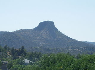
The Sierra Prieta is a 14 miles (23 km) long mountain range in central-northwest Arizona. The range is the mountainous region west of Prescott, with prominent Thumb Butte, 6,514 feet (1,985 m), a volcanic plug, on the city's west perimeter.

Toroweap Overlook is a viewpoint within the Grand Canyon National Park in Arizona, United States. It is located in a remote area on the North Rim of the Grand Canyon, 55 miles (89 km) west of the North Rim Headquarters. The overlook is the only viewpoint in the National Park from where the Colorado River can be seen vertically below. The overlook stands 3,000 feet (910 m) above the river.


Blair Gap, one of the gaps of the Allegheny, is a water gap along the eastern face atop the Allegheny Front escarpment. Like other gaps of the Allegheny, the slopes of Blair Gap were amenable to foot travel, pack mules, and possibly wagons allowing Amerindians, and then, after about 1778–1780 settlers, to travel west into the relatively depopulated Ohio Country decades before the railroads were born and tied the country together with steel.
Elephant Butte is a summit in Hidalgo County, New Mexico. It lies at an elevation of 6,361 feet, on the Cowboy Rim of the Animas Mountains.
Bennett Creek is a tributary stream in Hidalgo County, New Mexico.
Elephant Butte Canyon or Lawhorn Canyon is a canyon in the Animas Mountains of Hidalgo County, New Mexico. Its stream is a tributary of Walnut Creek. Its mouth is located at elevation 5,535 feet / 1,687 feet at its confluence with Walnut Creek, just below Lawhorn Tank. Its source is located at 3.5 miles north northeast of its mouth 31°36′25″N108°39′20″W at an elevation of 6,050 feet on the southwest slope of Elephant Butte.
Walnut Creek is an intermittent stream in Hidalgo County, New Mexico. It has its source in the Animas Mountains on the east slope of the Continental Divide at an elevation of 6,720 feet at 31°33′15″N108°41′37″W. Its mouth is located at an elevation of 4,524 feet where it subsides into the Playas Valley.