
Anambas Islands Regency is an island regency in the Riau Islands Province, Indonesia, located in the Natuna Sea. The regency consists of 255 islands, including five outer islands that are important for Indonesia's sovereignty boundaries, namely: Tokong Berlayar Island, Tokong Nanas Island, Mangkai Island, Damar Island, and Malangbiru Island. Anambas Islands Regency located 150 nautical miles northeast of Batam Island in the Natuna Sea between the Malaysian Peninsula to the west and the island of Borneo to the east. Geographically part of the Tudjuh Archipelago. This island regency covers a land area of approximately 661.47 square kilometres (255.39 sq mi) spread over an area of approximately 46,664 km² of water. The regency had a population of around 37,411 at the 2010 Census. and 47,402 at the 2020 Census; the official estimate as at mid 2023 was 50,140. The administrative centre is at Tarempa on Siantan Island.

The Lingga Regency is a group of 600 islands in Indonesia, located south of Singapore and along both sides of the equator, off the eastern coast of Riau Province on Sumatra island. They are due south of the populated Riau Archipelago, known for the industrial island of Batam and the tourist-frequented island of Bintan, although the Lingga Islands themselves are rarely visited due to the infrequent local transportation. The equator goes through the northern tip of Lingga Island, the main island in the archipelago.

Banyumas Regency is an inland regency in the southwestern part of Central Java province in Indonesia. Its capital is the town of Purwokerto, but that town no longer has a central administration and is split over four of the districts within the Regency, with a combined area of 41.65 km2 and a population of 234,467 as of mid-2023. The Regency covers an area of 1,391.15 km2, and had a population of 1,554,527 at the 2010 Census and 1,776,918 at the 2020 Census; the official estimate of the population as of mid-2023 was 1,828,573.

Sikka is a regency within East Nusa Tenggara province, Indonesia, on the island of Flores. It is bordered to the west by Ende Regency and to the east by East Flores Regency. It covers an area of 1,675.36 km2 and had a population of 300,301 at the 2010 census and 321,953 at the 2020 Census; the official estimate as at mid 2023 was 337,011. The capital is the town of Maumere, which comprises the districts of Alok Barat, Alok and Alok Timur.

Klaten Regency is a regency in Central Java province in Indonesia. It covers an area of 701.52 km2 and had a population of 1,130,047 at the 2010 Census and 1,260,506 at the 2020 Census; the official estimate as at mid 2023 was 1,284,386. Its administrative centre is in the town of the same name; the town extends over 36.88 km2 to encompass three of the regency's districts, with a combined total of 135,322 inhabitants in 2023; a fourth district (Kalikotes) is also part of its urban area.

Sukabumi Regency is a regency (kabupaten) in southwestern Java, as part of West Java province of Indonesia. The regency seat is located in Palabuhan Ratu, a coastal district facing the Indian Ocean. The regency fully encircles the administratively separated city of Sukabumi. Covering an area of 4,164.15 km2, the regency is the largest regency in West Java and the second largest regency on Java after the Banyuwangi Regency in East Java. The regency had a population of 2,341,409 at the 2010 census and 2,725,450 at the 2020 census; the official estimate as at mid 2023 was 2,802,404, with a large proportion of it living in the northeastern part of the regency that encircles Sukabumi City, south of Mount Gede. A plan to create a new regency, the putative North Sukabumi Regency, was considered by the Indonesian government in 2013, but has been deferred until the end of the current morotorium on new creations of regencies.

Cianjur Regency is a regency (kabupaten) of West Java, Indonesia. The area of the regency is 3,503.75 km2 and its population at the 2010 Census was 2,171,281; the 2020 Census produced a total of 2,477,560 and the official estimate published by the regency government as at mid 2023 was 2,535,002. The town (district) of Cianjur is its seat.
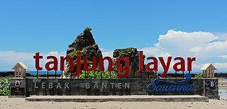
Lebak Regency is a regency of Banten province, Indonesia. It is located on the island of Java. The regency has an area of 3,481.35 km2 and had a population of 1,204,095 at the 2010 census and 1,386,793 at the 2020 census; the official estimate as at mid 2023 was 1,480,593. The town of Rangkasbitung in the north of the regency is the administrative centre. The regency is bordered by the Pandeglang Regency to the west, the Serang Regency to the north, and the Tangerang Regency to the north-east, by the Bogor and Sukabumi regencies to the east, and by the Indian Ocean to the south.

Pandeglang Regency is a regency of Banten province, Indonesia. It is mainly located on the west and south coasts of the island of Java and is the most westerly regency on Java Island, but it also includes several offshore islands such as Panaitan, Peucang, Deli and Tinjil. It is bounded by Serang Regency to the north, Lebak Regency to the east, the Java Sea to the south, and the Sunda Strait to the west. The regency has a land area of 3,053.13 km2, and a population at the 2010 Census of 1,149,610, rising to 1,272,687 at the 2020 Census; the official estimate as of mid-2023 was 1,391,056. The regency seat is the town of Pandeglang in the northeast of the regency, but the most densely-populated district outside of the northeast agglomeration is the town of Labuan on the west coast.

North Aceh Regency is a regency in Indonesia's Aceh Province - which was formerly called the Aceh special territory in 1959–2001), and then Nanggroë Aceh Darussalam in 2001–2009), before reverting to Aceh Province in 2009. It is located on the island of Sumatra. The regency covers an area of 3,296.86 square kilometres and had a population of 534,085 at the 2010 census and 602,793 at the 2020 Census; the official estimate as at mid 2023 was 624,582.

Brebes is a regency in the northwestern part of Central Java province in Indonesia. It covers an area of 1,769.62 km2, and it had a population of 1,733,869 at the 2010 Census and 1,978,759 at the 2020 Census; the official estimate as at end 2023 was 2,054,328. Its capital is the large town of Brebes in the northeast corner of the regency, immediately adjacent to the neighbouring city of Tegal.

South Aceh Regency is a regency in the Aceh province of Indonesia. It is located on the west coast of the island of Sumatra. The regency covers an area of 4,205.33 square kilometres and had a population of 202,251 at the 2010 Census, 224,588 in 2015 and 232,414 at the 2020 Census; the official population estimate in 2023 was 236,933. Its population density was thus 48.1 inhabitants/km2 at the 2010 census, 55.3 inhabitants/km2 at the 2020 census, and 56.3 inhabitants/km2 in 2023. The seat of the regency government is at Tapaktuan.

Kutai Kartanegara Regency is a regency of East Kalimantan Province, Indonesia. It has a land area of 27,263.10 km2 and a water area of 4,097 km2, geographically located between 1°18′40″S and 116°31′36″E. The population of the regency was 626,286 at the 2010 Census and 729,382 at the 2020 Census; the official estimate as of mid-2023 was 788,113. The town of Tenggarong is the capital of the regency.

Nias Selatan Regency is a regency in North Sumatra province, Indonesia, created on 25 February 2003 by the division of the existing Nias Regency. The regency covers a land area of 2,487.99 square kilometres and according to the 2010 census had a population of 289,708; the 2020 Census showed a population of 360,531, while the official estimate for mid 2023 was 368,834. Its administrative centre is the port of Teluk Dalam. Apart from the southern portion of Nias Island, the regency also includes the smaller Batu Islands to the south, lying between Nias and Siberut; these islands occupy nearly half of the land area of the Regency, but have just 9% of its population.

Manggarai Regency is a regency in East Nusa Tenggara province of Indonesia, situated on the island of Flores. Established in 1958 to encompass the 6,924.18 km2 area of the lands of the indigenous Manggarai people, the regency was reduced in area and in population by the separation of the more western districts to form West Manggarai Regency on 25 February 2003 and of the more eastern districts to form East Manggarai Regency on 17 July 2007.

Kupang Regency is a regency in East Nusa Tenggara province of Indonesia. It occupies the far western end of Timor Island, together with the smaller island of Semau and other minor offshore islands. Other islands further to the southwest and west which were formerly part of Kupang Regency have been separated administratively - the Rote Islands Group on 10 April 2002, and the Savu Islands Group on 29 October 2008.
Lembata Regency is a regency in East Nusa Tenggara province of Indonesia. Established on 4 October 1999 from the most easterly part of East Flores Regency, the regency covers the island of Lembata, together with three small offshore islands together forming the eastern part of the Solor Archipelago, and has its administrative seat (capital) in Lewoleba. The population of the Regency was 117,829 at the 2010 decennial census and at the 2020 census was 135,930; the official estimate as at mid 2023 was 137,812.
Nagekeo Regency is a regency on the island of Flores in East Nusa Tenggara province of Indonesia, comprising the Nage people in the south and the Keo in the north. It covers an area of 1,377.04 km2 and had a population of 130,120 at the 2010 Census, and 159,732 at the 2020 Census; the official estimate as at mid 2023 was 166,968. The regency was established on 2 January 2007 by separation of the former eastern districts from Ngada Regency; it has its administrative seat (capital) in the town of Mbay on the north coast of Flores. It is bordered to the west by the residual Ngada Regency and to the east by Ende Regency, while to the north is the Flores Sea and to the south is the Savu Sea.

Penajam North Paser Regency is a regency in the Indonesian province of East Kalimantan. Its administrative centre is the town of Penajam. The area which now forms Penajam North Paser was part of the Paser Regency until its creation as a separate regency on 10 April 2002. It covers an area of 3,455.86 km2 and it had 142,922 inhabitants at the 2010 census and 178,681 at the 2020 census; the official estimate as at mid-2023 was 196,566. Penajam North Paser Regency has the smallest area among the seven regencies in East Kalimantan province.
Sukamara Regency is one of the thirteen regencies which comprise the Central Kalimantan Province on the island of Kalimantan (Borneo), Indonesia. It was created on 10 April 2002 from the former southwest part of West Kotawaringin Regency. The town of Padang contains the administrative centre of Sukamara Regency, and had a population of 6,555 in mid 2023. The Regency covers an area of 3,827 km2, and had a population of 44,952 at the 2010 Census and 63,464 at the 2020 Census; the official estimate as at mid 2023 was 63,039.


