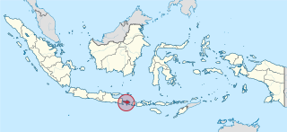
Bali is a province of Indonesia and the westernmost of the Lesser Sunda Islands. East of Java and west of Lombok, the province includes the island of Bali and a few smaller offshore islands, notably Nusa Penida, Nusa Lembongan, and Nusa Ceningan to the southeast. The provincial capital, Denpasar, is the most populous city in the Lesser Sunda Islands and the second-largest, after Makassar, in Eastern Indonesia. The upland town of Ubud in Greater Denpasar is considered Bali's cultural centre. The province is Indonesia's main tourist destination, with a significant rise in tourism since the 1980s, and becoming an Indonesian area of overtourism. Tourism-related business makes up 80% of the Bali economy.

Lombok is an island in West Nusa Tenggara province, Indonesia. It forms part of the chain of the Lesser Sunda Islands, with the Lombok Strait separating it from Bali to the west and the Alas Strait between it and Sumbawa to the east. It is roughly circular, with a "tail" to the southwest, about 70 kilometres across and a total area of about 4,607.38 square kilometres including smaller offshore islands. The provincial capital and largest city on the island is Mataram.

Seminyak is a mixed tourist residential area on the west coast of Bali in Indonesia, just north of Kuta and Legian.

Tourism in Indonesia is an important component of the Indonesian economy as well as a significant source of its foreign exchange revenues. Indonesia was ranked at 20th in the world tourist Industry in 2017, also ranked as the ninth-fastest growing tourist sector in the world, the third-fastest growing in Asia and fastest-growing in Southeast Asia. In 2018, Denpasar, Jakarta and Batam are among of 10 cities in the world with fastest growth in tourism, 32.7, 29.2 and 23.3 percent respectively. The tourism sector ranked as the 4th largest among goods and services export sectors.

Kuta is a tourist area, administratively an urban village (kelurahan), and the capital of Kuta District, Badung Regency, southern Bali, Indonesia. Kuta is a part of the Denpasar metropolitan area, 12 km (7.5 mi) south of downtown Denpasar. Originally known as a fishing village, it was one of the first towns on Bali to see substantial tourism, and as a beach resort remains one of Indonesia's major tourist destinations. It is known internationally for its long sandy beach, varied accommodations, restaurants and bars, and many renowned surfers who visit from Australia. It is near Bali's Ngurah Rai Airport.
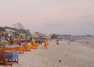
Jimbaran is an Indonesian fishing village and tourist resort in southern Bali, administered under South Kuta District of Badung Regency. Located south of Ngurah Rai International Airport at the "neck" of the Bukit Peninsula, the village is renowned as a culinary destination, with stalls selling seafood saturating the area. Diners select the live seafood that they wish to eat, and it is immediately prepared, generally grilled over a fire of coconut husks rather than charcoal.

The Bukit Peninsula is at the southern end of the island of Bali, Indonesia. It is traditionally considered to be the entire area south of Jimbaran beach. Unlike the bulk of Bali, it features a dry, arid and stony landscape. It is administered under Kuta South District. Bukit means 'hill' in Indonesian.

Nusa Dua is a resort area built in the 1970s in the southern part of Bali, Indonesia. Known as an enclave of large five-star resorts, it covers 350 hectares of land and encloses more than 20 resorts. It is located 22 kilometers from Denpasar, the provincial capital of Bali, and is administered as part of Benoa subdistrict (kelurahan) in South Kuta, Badung Regency. Nusa Dua means two islands, because there are two islands in the bay of Bali Tourism Development Corporation area. On the southern side lies Peninsula Island, and on the northern side lies Nusa Dharma Island, which is smaller but shadier, and which contains the Pura/Temple Nusa Dharma.

Legian is a suburban and beach area on the west coast of Bali in Indonesia, just north of Kuta and south of Seminyak, the area between Jl. Melasti and Jl. Dhyana Pura. Administratively it is a district of Kuta District within Badung Regency.

Sanur is a coastal stretch of beach east of Denpasar in southeast Bali, which has grown into a little town in its own right. A 5.1 km (3.2 mi) area of Sanur's coastline, from Matahari Terbit Beach to Mertasari Beach, was reclaimed in 2008.

Candi Dasa, or often Candidasa is a seaside town on the eastern cost of Bali that rests on the edge of a fresh water lagoon, named Candi Dasa Lagoon. The town is centred around Jalan Raya Candida, where a number of hotels, restaurants, and shops line the main road. It is popular tourist stop, attracting divers and those looking for a more sedate alternative to the busy, nightclub filled Kuta area or the large, manicured resorts at Nusa Dua.
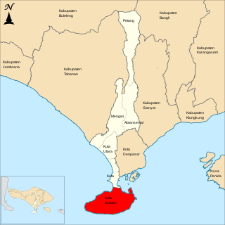
South Kuta is a district (kecamatan) within Badung Regency of Bali. It consists of Nusa Dua, a large peninsula projecting south from Bali island.
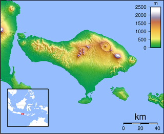
The History of Bali covers a period from the Paleolithic to the present, and is characterized by migrations of people and cultures from other parts of Asia. In the 16th century, the history of Bali started to be marked by Western influence with the arrival of Europeans, to become, after a long and difficult colonial period under the Dutch, an example of the preservation of traditional cultures and a key tourist destination.

Central Lombok Regency is a regency of the Indonesian Province of West Nusa Tenggara. It is located on the island of Lombok and the capital is Praya. It covers an area of 1,208.39 km2, and had a population of 859,309 at the 2010 census and 1,034,859 at the 2020 census; the official estimate as at mid 2023 was 1,099,211.

Canggu is a coastal village and 10 km beach on the south coast of Bali, Indonesia. It lies approximately 10 kilometers north of Kuta.

Pecatu is a village (desa) in South Kuta, Bali, Indonesia. Located in the western side of the Bukit Peninsula, its hilly landscape creates smaller, more isolated beaches than at Nusa Dua on the eastern side of the peninsula. It is popular with surfers and also with nudists. The Uluwatu Temple is also located at Pecatu.

Introduced to Indonesia in the 1930s, surfing now attracts both Indonesian and foreign surfers to numerous locations across the nation.

Uluwatu is a region on the south-western tip of the Bukit Peninsula of Bali, Indonesia. It is home to the Pura Luhur Uluwatu temple.
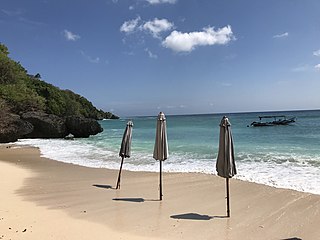
Padang Padang Beach is a 110m long sandy beach in Pecatu on the Bukit Peninsula in Bali, Indonesia. It is characterised by fine white sand and tall cliffs.


