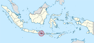
Bali is a province of Indonesia and the westernmost of the Lesser Sunda Islands. East of Java and west of Lombok, the province includes the island of Bali and a few smaller neighbouring islands, notably Nusa Penida, Nusa Lembongan, and Nusa Ceningan. The provincial capital, Denpasar, is the most populous city in the Lesser Sunda Islands and the second-largest, after Makassar, in Eastern Indonesia. The upland town of Ubud in Greater Denpasar is considered Bali's cultural centre. The province is Indonesia's main tourist destination, with a significant rise in tourism since the 1980s. Tourism-related business makes up 80% of its economy.

Kuta is a tourist area, administratively an urban village (kelurahan), and the capital of Kuta District, Badung Regency, southern Bali, Indonesia. A former fishing village, it was one of the first towns on Bali to see substantial tourist development, and as a beach resort remains one of Indonesia's major tourist destinations. It is known internationally for its long sandy beach, varied accommodation, many restaurants and bars, and many renowned surfers who visit from Australia. It is located near Bali's Ngurah Rai Airport.
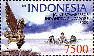
Singaraja is a port town in northern Bali, Indonesia, which serves as the seat of Buleleng Regency. The name is Indonesian for "Lion King". It is just east of Lovina, and is also the centre of Buleleng District, which covers an area of 46.94 km² and had a population of 150,210 in 2020, the second largest on the island.
Dreamland Beach, now officially known as New Kuta Beach, is a beach located in Pecatu on the Bukit Peninsula on the island of Bali, Indonesia. A popular surfing beach, it was formerly secluded and had casual refreshment stands and inns. It has since become the beach of an extensive tourist development.

Nusa Dua is a resort area built in the 1970s in the southern part of Bali, Indonesia. Known as an enclave of large five-star resorts, it covers 350 hectares of land and encloses more than 20 resorts. It is located 22 kilometers from Denpasar, the provincial capital of Bali, and is administered under South Kuta District, Badung Regency. Nusa Dua means two islands, because there are two islands in the bay of Bali Tourism Development Corporation area. On the southern side lies Peninsula Island, and on the northern side lies Nusa Dharma Island, which is smaller but shadier, and which contains the Pura/Temple Nusa Dharma.

Tanah Lot is a rock formation surrounded by sea at southern Tabanan beach in Indonesian island of Bali. It is home to the sacred and ancient Balinese temple of Pura Tanah Lot, a popular tourist and cultural icon for pilgrimage and photography.

Asian Highway 2 (AH2) is a road in the Asian Highway Network running 13,107 kilometres (8,144 mi) from Denpasar, Indonesia to Merak and Singapore to Khosravi, Iran. The route is connected to M10 of the Arab Mashreq International Road Network. The route is as follows:
Legian is a suburban and beach area on the west coast of Bali in Indonesia, just north of Kuta and south of Seminyak, the area between Jl. Melasti and Jl. Dhyana Pura. Administratively it is a district of Kuta District within Badung Regency.
Bukit, the Indonesian or Malay word for hill, may refer to:
The Bali Sea is the body of water north of the island of Bali and south of Kangean Island in Indonesia. The sea forms the south-west part of the Flores Sea, and the Madura Strait opens into it from the west.

Pura Ulun Danu Beratan, or Pura Bratan, is a major Hindu Shaivite temple in Bali, Indonesia. The temple complex is on the shores of Lake Bratan in the mountains near Bedugul. The water from the lake serves the entire region in the outflow area; downstream there are many smaller water temples that are specific to each irrigation association (subak).
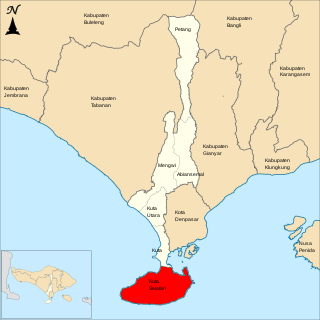
South Kuta is a district (kecamatan) within Badung Regency of Bali. It consists of Nusa Dua, a large peninsula projecting south from Bali island.
The History of Bali covers a period from the Paleolithic to the present, and is characterized by migrations of people and cultures from other parts of Asia. In the 16th century, the history of Bali started to be marked by Western influence with the arrival of Europeans, to become, after a long and difficult colonial period under the Dutch, an example of the preservation of traditional cultures and a key tourist destination.

Tirta Empul temple is a Hindu Balinese water temple located near the town of Tampaksiring, Bali, Indonesia. The temple compound consists of a petirtaan or bathing structure, famous for its holy spring water, where Balinese Hindus go to for ritual purification. The temple pond has a spring which gives out fresh water regularly, which Balinese Hindus consider to be holy or amritha. Tirta Empul means Holy Spring in Balinese.
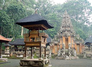
A pura is a Balinese Hindu temple, and the place of worship for adherents of Balinese Hinduism in Indonesia. Puras are built in accordance to rules, style, guidance and rituals found in Balinese architecture. Most puras are found on the island of Bali, where Hinduism is the predominant religion; however many puras exist in other parts of Indonesia where significant numbers of Balinese people reside. Mother Temple of Besakih is the most important, largest and holiest temple in Bali. Many puras have been built in Bali, leading it to be titled "the Island of a Thousand Puras".

Pecatu is a region in the west of the Bukit Peninsula of Bali. Its hilly landscape creates smaller, more isolated beaches than at Nusa Dua on the eastern side of the peninsula. It is popular with surfers and also with nudists.

Museum Pasifika is an art museum in Bali, Indonesia. It presents the Asian Pacific’s variety of cultural artefacts. The museum was founded in 2006 by Moetaryanto P and Philippe Augier, and designed Popo Danes.
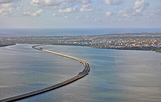
Bali Mandara Toll Road or Nusa Dua-Ngurah Rai-Benoa Toll Road is a toll road carried by a bridge stretching across the Gulf of Benoa 12.7 km in length. The Rp 2.48 Trillion highway connects the city of Denpasar and South Kuta, Badung Regency, Nusa Dua and Ngurah Rai International Airport. The reason behind construction of Bali Mandara Toll Road was to prevent traffic jams on the Ngurah Rai Bypass Road, previously the only road connecting areas of Bali south of the airport with areas north of the airport. The Ngurah Rai Bypass Road, a land-based route, could not be widened because of the location of the airport runway. Consequently, the Bali Mandara Toll Road was built over water.
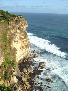
Uluwatu is a region on the south-western tip of the Bukit Peninsula of Bali, Indonesia. It is home to the Pura Luhur Uluwatu Temple.
