The Barat Daya Islands are a group of islands in the Maluku province of Indonesia. The Indonesian phrase barat daya means 'south-west'.

The Babar Islands(Indonesian: Kepulauan Babar) are located in Maluku Province, Indonesia between latitudes 7 degrees 31 minutes South to 8 degrees 13 minutes South and from longitudes 129 degrees 30 minutes East to 130 degrees 05 minutes East. The group now constitutes five districts (kecamatan) within the Maluku Barat Daya Regency of Maluku province.
Sikka is a regency within East Nusa Tenggara province, Indonesia, on the island of Flores. It is bordered to the west by Ende Regency and to the east by East Flores Regency. It covers an area of 1,675.36 km2 and had a population of 300,301 at the 2010 census and 321,953 at the 2020 Census; the official estimate as at mid 2023 was 335,360 - comprising 163,060 males and 172,300 females). The capital is the town of Maumere, which comprises the districts of Alok Barat, Alok and Alok Timur.

Nunukan Regency is a regency of North Kalimantan Province in Indonesia. It was created on 4 October 1999 from the northern districts of Bulungan Regency. Nunukan Regency shares international borders with the Malaysian states of Sabah to the north and Sarawak to the west, and inter-regency borders with Tana Tidung Regency and Malinau Regency to the south, as well as the coastal city of Tarakan in the east. The regency covers an area of 14,247.50 km2 and it had a population of 140,841 at the 2010 census and 199,090 at the 2020 census; the official estimate as at mid 2022 was 208,303.

Pesisir Selatan Regency is a regency (kabupaten) of West Sumatra, Indonesia. It has an area of 6,049.33 km² and a population of 429,246 at the 2010 Census and 504,418 at the 2020 Census; the official estimate as at mid-2022 was 516,518. The regency seat is at the town of Painan, in IV Jurai District.
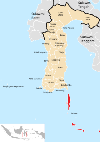
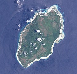
The Selayar Islands Regency is a regency of Indonesia in South Sulawesi province that covers the Selayar Islands, which lie southeast of the southern peninsula of Sulawesi. The archipelago consists of the group's main island, which is surrounded by 41 smaller islands around its coast; further to the southeast lies a widespread group of islands, including the huge atoll of Takabonerate. The regency covers an area of 1,357.03 km2, and had a population of 103,596 at the 2000 Census, 122,055 at the Census of 2010 and 137,071 at that of 2020. The official estimate for mid 2022 was 139,145. The administrative centre is the town of Benteng on Selayar Island. The Selayar Straits separate the regency from Sulawesi island.

South Aceh Regency is a regency in the Aceh province of Indonesia. It is located on the west coast of the island of Sumatra. The regency covers an area of 4,173.82 square kilometres and had a population of 202,251 at the 2010 Census, 224,588 in 2015 and 232,414 at the 2020 Census; the official estimate as at mid 2023 was 239,475 . Its population density was thus 48.5 inhabitants/km2 at the 2010 census, 53.8 inhabitants/km2 in 2015, 55.7 inhabitants/km2 at the 2020 census, and 57.4 inhabitants/km2 in mid 2023. The seat of the regency government is at Tapaktuan.

Alor Regency is a regency (kabupaten) in East Nusa Tenggara (NTT) province of Indonesia. Established in 1958, Alor Regency administers the Alor Archipelago with its seat (capital) in Kalabahi on Alor Island.

The Tayandu or Tayando Islands are a group of low-lying islands just west of the larger Kai Islands of Maluku, Indonesia. The group of 27 islands consists of Tayando, Walir, Heniar and several smaller islets. Between Walir and Taam is Pulau Nusreen featuring a large sandy lagoon. Administratively, the group comprises a district (kecamatan) within the city of Tual. Further west lies Manggur Island with Kur and Kaimeer islands north of it, but these comprise two other districts within the city, and are not within the Tayando Tam District.

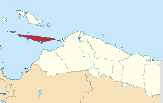
Nias Selatan Regency is a regency in North Sumatra province, Indonesia, created on 25 February 2003 by the division of the existing Nias Regency. The regency covers a land area of 2,487.99 square kilometres and according to the 2010 census had a population of 289,708; the 2020 Census showed a population of 360,531, while the official estimate for mid 2023 was 382,539. Its administrative centre is the port of Teluk Dalam. Apart from the southern portion of Nias Island, the regency also includes the smaller Batu Islands to the south, lying between Nias and Siberut; these islands occupy nearly half of the land area of the Regency, but have just 9% of its population.
Yapen Islands Regency is a regency (kabupaten) in Papua Province of eastern Indonesia. It covers an area of 2,432.49 km2 (939.19 sq mi), and had a population of 82,951 at the 2010 Census and 112,676 at the 2020 Census; the official estimate as at mid 2022 was 116,107. It comprises an archipelago which lies in Cenderawasih Bay off the north coast of Western New Guinea.
South Halmahera Regency is a regency of North Maluku Province, Indonesia. It lies partly on Halmahera Island and partly on smaller islands to the west and south of Halmahera. It covers a land area of 8,779.32 km2, and at the 2010 Census it had a population of 198,911 people, while the 2020 Census showed that this had risen to 248,395 and the official estimate in mid 2022 was 253,331. The capital lies at the town of Labuha on Bacan Island.

Kapuas Regency is one of the thirteen regencies which divide Central Kalimantan Province, on the island of Kalimantan, Indonesia. It formerly covered a wider area, but on 10 April 2002 two further regencies were cut out of its western districts, and the residual area is now 14,999 km.2 Its population was 329,646 at the 2010 Census and 410,446 at the 2020 Census; the official estimate as at mid 2022 was 423,210. The administrative centre is the town of Kuala Kapuas near the coast, but the largest town is Selat, which includes 8 of the regency's 15 urban kelurahan, and had 73,900 inhabitants in 2022.

South Lampung Regency is a regency of Lampung, Sumatra, Indonesia, a strip of land surrounding the provincial capital of Bandar Lampung on its northern and eastern sides, and bounded to the west by the new Pesawaran Regency and to the south by the Sunda Strait; as such it is a major transit corridor to/from Java island. It has an area of 2,109.74 km2, and a population of 909,989 at the 2010 census and 1,064,301 at the 2020 census; the official estimate as at mid 2022 was 1,081,115. The regency seat is the town of Kalianda.

Tanggamus Regency is a regency (kabupaten) of Lampung Province, Sumatra, Indonesia. It has an area of 4,654.96 km² and had a population of 534,595 at the 2010 Census and 640,275 at the 2020 Census; the official estimate as at mid 2022 was 652,898. The regency seat is the town of Kota Agung Pusat. The regency was created on 21 March 1997, but districts in its eastern part were split away on 29 October 2008 to form a new Pringsewu Regency. It lies in the southwest of the province, and surrounds Semangka Bay on its west, north and east coasts.

Takalar Regency is a regency of South Sulawesi Province, Indonesia. It covers an area of 566.51 km2 and had a population of 269,603 at the 2010 census and 300,853 at the 2020 census; the official estimate for mid 2022 was 305,077. The entire regency lies within the official metropolitan area of the city of Makassar. The principal towns are at Galesong and Takalar, but the administrative centre is at Pattallassang.

Southeast Maluku Regency is a regency of Maluku, Indonesia. It is coincident with the Kei Islands, except that the city of Tual, although within the Kei Islands geographically and the seat of the Regency's administration, is since 17 July 2007 technically independent of the Regency. The land area of the Regency is 1,031.01 km2, while the sea area administered by the Regency was 3,181 km2; it had a population of 96,442 at the 2010 Census; this increased to 121,511 at the 2020 Census, and the official estimate as at mid 2023 was 129,034.

Southwest Maluku Regency is a regency of Maluku Province, Indonesia. Geographically it forms the most eastern portion of the Lesser Sunda Islands, although it has never been administratively included with them, and politically has always comprised a part of the Maluku Province. It comprises a number of islands and island groups in the south of the province, including Lirang Island, Wetar Island, Kisar Island, Romang Island, the Letti Islands, the Damer Islands, the Sermata Islands and the Babar Islands. The total land area is 4,581.06 km2, and the population was 70,714 at the 2010 Census and 81,928 at the 2020 Census; the official estimate as at mid 2023 was 93,766.

Tual is a city in Maluku Province of Indonesia, geographically located within the Kei Islands. On 17 July 2007, it was separated from the rest of the Kei Islands and was created an independent city.