
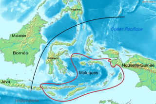
The Maluku Islands or the Moluccas are an archipelago in the eastern part of Indonesia. Tectonically they are located on the Halmahera Plate within the Molucca Sea Collision Zone. Geographically they are located east of Sulawesi, west of New Guinea, and north and east of Timor. Lying within Wallacea, the Moluccas have been considered a geographical and cultural intersection of Asia and Oceania.

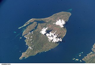
Ambon Island is part of the Maluku Islands of Indonesia. The island has an area of 743.37 km2 (287.02 sq mi) and is mountainous, well watered, and fertile. Ambon Island consists of two territories: the city of Ambon to the south and various districts (kecamatan) of the Central Maluku Regency to the north. The main city and seaport is Ambon, which is also the capital of Maluku province, while those districts of Maluku Tengah Regency situated on Ambon Island had a 2020 Census population of 128,069. Ambon has an airport and is home to the Pattimura University and Open University, state universities, and a few private universities, which include Darussalam University and Universitas Kristen Indonesia Maluku (UKIM).

Seram is the largest and main island of Maluku province of Indonesia, despite Ambon Island's historical importance. It is located just north of the smaller Ambon Island and a few other adjacent islands, such as Saparua, Haruku, Nusa Laut and the Banda Islands.
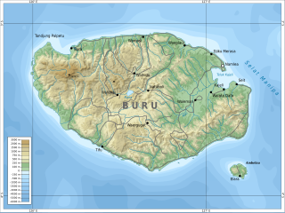
Buru is the third largest island within the Maluku Islands of Indonesia. It lies between the Banda Sea to the south and Seram Sea to the north, west of Ambon and Seram islands. The island belongs to Maluku province and includes the Buru and South Buru regencies. Their administrative centers, Namlea and Namrole, respectively, have ports and are the largest towns of the island, served by Namlea Airport and Namrole Airport respectively.

Maluku is a province of Indonesia. It comprises the central and southern regions of the Maluku Islands. The largest city and capital of Maluku province is Ambon on the small Ambon Island. It is directly adjacent to North Maluku, Southwest Papua, and West Papua in the north, Central Sulawesi, and Southeast Sulawesi in the west, Banda Sea, Australia, East Timor and East Nusa Tenggara in the south and Arafura Sea, Central Papua and South Papua in the east. The land area is 46,150.92 km2, and the total population of this province at the 2010 census was 1,533,506 people, rising to 1,848,923 at the 2020 census, the official estimate as at mid 2022 was 1,881,727. Maluku is located in Eastern Indonesia.
The Central Malayo-Polynesian languages (CMP) are a proposed branch in the Malayo-Polynesian subgroup of the Austronesian language family. The languages are spoken in the Lesser Sunda and Maluku Islands of the Banda Sea, in an area corresponding closely to the Indonesian provinces of East Nusa Tenggara and Maluku and the nation of East Timor, but with the Bima language extending to the eastern half of Sumbawa Island in the province of West Nusa Tenggara and the Sula languages of the Sula archipelago in the southwest corner of the province of North Maluku. The principal islands in this region are Sumbawa, Sumba, Flores, Timor, Buru, and Seram. The numerically most important languages are Bima, Manggarai of western Flores, Uab Meto of West Timor, and Tetum, the national language of East Timor.

Thomas Matulessy, also known as Kapitan Pattimura or simply Pattimura, was a famous Ambonese soldier who became a symbol of both the Maluku and Indonesian struggle for independence, praised by President Sukarno and declared a national hero by President Suharto. He has several namesakes in both the Netherlands and in the Indonesian archipelago.

The black-bearded flying fox is an endangered species of megabat in the genus Pteropus. It is endemic to Indonesia, found on the islands of Ambon, Buru, Seram, Banda, and Yamdena. Currently considered monotypic, it formerly included the Aru flying fox and Kei flying fox as subspecies.

Central Maluku Regency is a regency of Maluku Province of Indonesia. The Regency covers an area of 11,595.57 km2, and had a population of 361,698 at the 2010 Census, and 423,094 at the 2020 Census. The official estimate as at mid 2022 was 427,050. The principal town lies at Masohi, on Seram Island. The regency (kebupaten) is composed of the central part of the island of Seram, the Banda Islands, and the Lease Islands, together with those parts of Ambon Island which are outside the City of Ambon.
West Seram Regency is a regency of Maluku, Indonesia. It is mainly located on Seram, but includes various islands lying to the west of Seram -- Manipa, Kelang, Boano, as well as the smaller islets of Babi, Pua, Masowoi, and Marsegu. It covers a land area of 6,948.40 km2, and had a population of 164,654 at the 2010 Census and 212,393 at the 2020 Census; the official estimate as at mid 2022 was 212,960. The principal town lies at Piru, a port at the northern coast of Latira Bay which almost separates the Huamual Peninsula from the rest of Seram Island. The western sector of the Regency occupies just under 25% of the land area, but held over 42% of the Regency's population at the 2020 Census.

The Seram boobook is a species of owl in the family Strigidae. It is found on the Indonesian islands of Seram, Kelang and Ambon. Its natural habitat is subtropical or tropical moist lowland forests. It is threatened by habitat loss. It used to be considered a subspecies of the Moluccan boobook.
Luhu is an Austronesian spoken in the west of Seram Island in eastern Indonesia. It is spoken in Luhu village on Hoamoal Peninsula at the western end of Seram, and in Boano and Kelang islands, off the western tip of Seram Island.
Serua is an almost extinct Austronesian language originally spoken on Serua Island in Maluku, Indonesia. Speakers were relocated to Seram due to volcanic activity on Serua. The language continues in communities in Waipia in Seram, where the islanders were resettled, along with those also from Nila and Teun. Here, the older generation retain the island language as a strong form of identity.
Boano Island is an island in West Seram Regency, Maluku Province, Indonesia. It is located off the northern coast of the Hoamoal Peninsula at the western end of Seram Island, across the Boano Strait. The inhabitants speak the Boano, Luhu, as well as Indonesian and Ambonese Malay.

Manipa Island is an island in West Seram Regency, Maluku Province, Indonesia. It is located 8 km off the western coast of Kelang at the western end of Seram Island and 25 km off the western coast of Buru. Including adjacent small islands, it covers an area of 159.71 km2. The inhabitants speak the Manipa language, as well as Indonesian and Ambonese Malay.
Masiwang River is a river of eastern Seram Island, Maluku province, Indonesia, about 2700 km northeast of the capital Jakarta.
Sapalewa River, also Sapolewa, is a river of Seram Island, Maluku province, Indonesia, about 2400 km northeast of the capital Jakarta.
The Eti River is a river of Seram Island, Maluku province, Indonesia, about 2400 km northeast of the capital Jakarta. It flows into the sea on the southwest side of the island, a few kilometres south of the town of Piru, West Seram Regency.
The Tala River is a river of western Seram Island, Maluku province, Indonesia, about 2400 km northeast of the capital Jakarta.
Salawai River is a river of Seram Island, Maluku province, Indonesia, about 2500 km northeast of the capital Jakarta.
