Bacan Islands

Last updated
Bacan
Bacan Topography.png
Topographic map of Bacan and other nearby islands.
ID Bacan.PNG
Geography
Location South East Asia
Coordinates 00°36′54″S127°30′54″E / 0.61500°S 127.51500°E / -0.61500; 127.51500
Archipelago Moluccas (Maluku Islands)
Area2,792.85 km2 (1,078.33 sq mi)
Highest elevation2,111 m (6926 ft)
Highest point Buku Sibela
Administration
Demographics
Population115,612 (mid 2022)
Pop. density414/km2 (1072/sq mi)
The position of the Bacans in the Moluccas Maluku Islands en.png
The position of the Bacans in the Moluccas

The Bacan Islands, formerly also known as the Bachans, Bachians, and Batchians, [1] are a group of islands in the Moluccas in Indonesia. They are mountainous and forested, lying south of Ternate and southwest of Halmahera. The islands are administered by the South Halmahera Regency of North Maluku Province. They formerly constituted the Sultanate of Bacan.

Contents

Bacan (Dutch : Batjan), [2] formerly also known as Bachian [3] [2] or Batchian, [4] is the group's largest island. The second and third-largest islands are Kasiruta and Mandioli. [3] Bacan Island in 2020 included about 82,387 people, of which about 10,000 live in the capital Labuha; it is subdivided into seven districts. Kasiruta and Mandioli each have over 11,000 inhabitants, and each is subdivided into two districts. A fourth island, Bacan Lomang, forms a twelfth district within the group. There are dozens of smaller islands in the group, which had a total population of 84,075 at the 2010 Census, [5] but by the 2020 Census had risen to 111,517. [6] The official estimate as at mid 2022 was 115,612. [7]

Administration

The group is divided into twelve administrative districts (kecamatan) out of the thirty districts within South Halmahera Regency. They are tabulated below with their areas and their populations at the 2010 Census [8] and 2020 Census, [9] together with the official estimate for mid 2022. [10] The table also includes the number of administrative villages (desa and kelurahan) in each district and its post code.

NameEnglish nameArea in
km2
Population
census
2010
Population
census
2020 [11]
Population
estimate
mid 2022 [12]
Admin.
centre
No.
of
villages
No.
of
islands
Post
code
Island
or group
Bacan Timur SelatanSoutheast Bacan321.136,4607,4938,009Wayaua7197791Bacan Islands
Bacan Timur TengahEast Central Bacan276.285,2296,1586,495Bibinoi7297791Bacan Islands
Bacan TimurEast Bacan463.509,05112,79413,267Babang10897791Bacan Islands
Bacan SelatanSouth Bacan169.2113,26519,56020,006Mandaong10-97791Bacan Islands
Bacan304.6919,09227,04527,885 Labuha 14397791Bacan Islands
Bacan Barat UtaraNorthwest Bacan264.944,0965,0105,237Yaba8197791Bacan Islands
Bacan BaratWest Bacan180.783,5494,3274,620Indari74997791Bacan Islands
Batang Lomang (a)Batang Lomang Islands55.816,1777,6557,929Bajo81397790Batang Lomang Islands
Mandioli SelatanSouth Mandioli138.815,7986,9367,230Jiko6-97791Mandioli
Mandioli UtaraNorth Mandioli96.792,9903,8093,949Indong6797791
-97792
Mandioli
Kasiruta TimurEast Kasiruta247.933,8474,8655,189Loleojaya8697790Kasiruta
Kasiruta BaratWest Kasiruta272.984,5215,8655,896Palamea102597790Kasiruta

History

From early times, Bacan was one of the four kingdoms of Maluku together with Ternate, Tidore and Jailolo. The ruling elite converted to Islam in about the late 15th century. The sultan at first resided on Kasiruta Island and had political and commercial influence in northern Ceram and the Papuan Islands. In 1513, the first Portuguese trading fleet to reach the Moluccas set up a trading post on Bacan which at the time was tied to the Sultan of Ternate by dynastic marriages. The fleet's commander, Captain Antonio de Miranda Azevedo, left seven men on Bacan to buy cloves for the following year's expedition. Their arrogant behaviour and reported bad treatment of Bacan women led to their murder. As Ternate did not have enough stock, the ship for which the men had stayed to prepare was used by the Sultan of Ternate to fill Ferdinand Magellan's last ship, which was the first ship to circumnavigate the world. A slave and two birds of paradise were given to the ship by Bacan. Bacan became a place of refuge for rebellious Ternatans. The Portuguese sent a punitive expedition against Bacan but it failed, and instead the Portuguese Governor Galvão challenged Bacan's sultan to a duel to determine who was to be subservient to whom. The challenge was accepted but the duel never took place. [13]

In 1557, Father Antonio Vaz converted Bacan's sultan and court members to Catholicism. The king was married to a daughter of Sultan Hairun of Ternate. Fleets from Ternate invaded the islands in 1570 and later and the king apostatized in 1575, though he was nevertheless poisoned in 1578. A community of Christians remained and were later joined by coreligionists from Tobelo and Ambon. A small Roman Catholic hospital was built by an elderly Dutch nun. Today, Protestants significantly outnumber Catholics. During the mid-19th century Moluccan travels of British naturalist Alfred Russel Wallace, Christians in the Moluccas were called Orang Sirani (lit. "Nazarene People"), a term regularly applied to locals of European ancestry in the Malay Archipelago, thought to have been descended from the Portuguese. They had dressed in white and black and Wallace reports they dance "quadrilles, waltzes, polkas, and mazurkas with great vigour and much skill". [13]

Following the 1575 Ternatan invasion, Bacan become subservient to Ternate for periods, which was sealed through marriages. A sister and a daughter of Sultan Saidi Berkat of Ternate married Bacan rulers in the late 16th and early 17th centuries. A Spanish fort was built in 1606. By this time the seat of the sultan had been moved from Kasiruta to Bacan Island. Once the Dutch East India Company established hegemony in 1609, the Netherlands' power on Bacan was based in Fort Barnaveld. [13]

In 1705, the sergeant in charge of the fort and the sultan captured the English explorer William Dampier, seized his ship, looted its cargo, and threatened all aboard with execution. It is thought that this was in response to Dampier violating the trade monopoly. When the sergeant's Dutch superiors heard of the incident, Dampier was released, his ship restored and the English provided with sumptuous hospitality in Ternate. [14] The chief town at the time, also known as Bachian, was Amasing or Amasingkota on the island's isthmus. [3]

Ternate and Bacan were the only places in the northern Moluccas that had a Dutch curriculum school and a Protestant minister in the late 19th century. The majority of Bacan's Roman Catholics became Protestants during the Dutch colonial period.[ citation needed ] These Sirani wore semi-European dress and celebrated Sundays with dancing and music. [3] The Sultanate of Bacan was treated as a Dutch protectorate; [3] it was replaced by a council of chiefs under a Dutch contrôleur in 1889. [2] A sultan with much reduced powers was eventually appointed in 1900. What independence remained was lost with the Japanese occupation during and Indonesian independence after World War II. [15] The most significant modern town is Labuha on the west coast. Bacan has more recently been in the news due to violence between Christian and Muslim inhabitants of the island.

Geography

German map from 1896 Batjan map.jpg
German map from 1896

Bacan is of irregular form, consisting of two distinct mountainous parts, united by a low isthmus, which a slight subsidence would submerge. [3] The total land area is around 1,900 km2.[ citation needed ] The prevailing rocks are sandstone, coralline limestone, and pebbly conglomerate, although hot springs attest to volcanic activity as well. [3] The ancient and non-volcanic rocks are especially prevalent on the south side of the island. [2] The sulphur spring at Taubenkit has a temperature of 125 °F (52 °C) and a still more remarkable example is found at Sayowang on the east coast. [3] "Amasing Hill" on the northern half consists of three small andesitic volcanoes: Cakasuanggi, Dua Saudara, and Mount Sibela. The highest elevation on the southern half is Gunong Sabella [3] or Labua (6,950 ft or 2,120 m), [2] which the locals traditionally considered the seat of evil spirits. [3] Coal and other minerals have been discovered. [3]

During the 19th and early 20th century, large portions of the island were richly wooded, with indigenous sago, coconuts and cloves abundantly produced. [3] [2] The Dutch purposefully exterminated the native nutmeg trees: a large grove still remained as late as the 1870s [3] but it had disappeared by the onset of World War I. [2] It is the easternmost point naturally inhabited by primates, in the form of a black macaque which also occurs on Sulawesi. [2] The world's largest bee, the giant mason bee, occurs here and on nearby Halmahera.

Demography

By the mid-19th century, the interior of Bacan island was considered uninhabited and the coastal dwellers all non-indigenous. [3] They consisted of the Christian descendants of Portuguese sailors (Sirani), of Malays and Papuans, of Galelas from northern Halmahera, and of Tomore people from Sulawesi's Bay of Tolo. [3] Prior to World War I, the population of the island was around 13000, including some Chinese and Arabs. [2] In the late 1990s, 193 of Bacan's 7,700 Christians were Protestants. [15] The whole group had a population of 84,075 at the 2010 Census, but by mid 2022 had grown to 115,612.

Several non-Austronesian (Papuan) languages are spoken on Bacan, the main one of which is Galela but also Tobelo and Ternate. Near the capital Labuha, Bacanese Malay was once spoken, but as of 2012 it had only handful of speakers remaining. [16]

Economy

Colonial interest in Bacan was primarily driven by the spice trade, which was flourishing in Ternate, Tidore, and Halmahera. The island of Bacan was not particularly sought-after for its own resources, but rather, to assist control of the more valuable islands nearby. The Dutch East India Company paid a stipend to the Bacan sultan as compensation for the destruction of Bacan's clove trees that was higher than the salary of the Dutch Governor on Ternate and about 1/9 of that paid to the Sultan of Ternate.

It is thought that gold was washed on Bacan since at least 1774; in the mid-nineteenth century, 20 skilled Chinese gold workers were brought from west Borneo but a gold rush did not eventuate.[ citation needed ] During the era of steam power, an attempt was made to establish coal mining on the island [3] using Japanese convicts imprisoned by the Dutch. However, following the delivery of several tons the grade of coal was deemed poor and the mining was discontinued.

From 1882, an Amsterdam merchant cleared plantations for vanilla, coffee, tobacco and potatoes, however, his land was unsuitable and the crops succumbed to floods, drought, rot, insects and rodents. Despite over ten years of large investments of capital, creditors forced him out of business in 1900 although they also did not succeed with the plantations. [14] The indigenous economy included the gathering of pearl and mother-of-pearl, and the harvesting the resin from dammar.

See also

Notes

  1. "Bacan | island, Indonesia". Encyclopedia Britannica. Archived from the original on 2020-02-18. Retrieved 2020-05-29.
  2. 1 2 3 4 5 6 7 8 9 EB (1911), p. 132.
  3. 1 2 3 4 5 6 7 8 9 10 11 12 13 14 15 16 EB (1878).
  4. Encyclopædia Britannica, 9th ed., Index, p. 39. 1889.
  5. Biro Pusat Statistik, Jakarta, 2011.
  6. Badan Pusat Statistik, Jakarta, 2021.
  7. Badan Pusat Statistik, Jakarta, 2023.
  8. Biro Pusat Statistik, Jakarta, 2011.
  9. Badan Pusat Statistik, Jakarta, 2021.
  10. Badan Pusat Statistik, Jakarta, 2023.
  11. Badan Pusat Statistik, Jakarta, 2021.
  12. Badan Pusat Statistik, Jakarta, 2023.
  13. 1 2 3 Muller (1997), p. 130.
  14. 1 2 Muller (1997), p. 131.
  15. 1 2 Muller (1997), p. 132.
  16. Bacanese Malay at Ethnologue (22nd ed., 2019) Closed Access logo transparent.svg

Related Research Articles

<span class="mw-page-title-main">Maluku Islands</span> Archipelago in eastern Indonesia

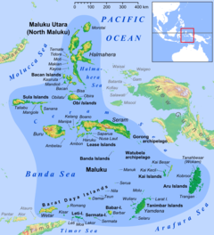
The Maluku Islands or the Moluccas are an archipelago in the eastern part of Indonesia. Tectonically they are located on the Halmahera Plate within the Molucca Sea Collision Zone. Geographically they are located east of Sulawesi, west of New Guinea, and north and east of Timor. Lying within Wallacea, the Moluccas have been considered as a geographical and cultural intersection of Asia and Oceania.

<span class="mw-page-title-main">North Maluku</span> Province of Indonesia

North Maluku is a province of Indonesia. It covers the northern part of the Maluku Islands, bordering the Pacific Ocean to the north, the Halmahera Sea to the east, the Molucca Sea to the west, and the Seram Sea to the south. It shares a maritime borders with North Sulawesi,, Southeast Sulawesi and Central Sulawesi to the west, Maluku to the south, Southwest Papua to the west, and Palau and the Philippines to the north. The provincial capital is Sofifi on the largest island of Halmahera, while the largest city is the island city of Ternate. The population of North Maluku was 1,038,087 in the 2010 census, making it one of the least-populous provinces in Indonesia, but by the 2020 Census the population had risen to 1,282,937, and the official estimate as at mid 2022 was 1,319,338.

<span class="mw-page-title-main">Maluku (province)</span> Province of Indonesia

Maluku is a province of Indonesia. It comprises the central and southern regions of the Maluku Islands. The largest city and capital of Maluku province is Ambon on the small Ambon Island. It is directly adjacent to North Maluku, Southwest Papua, and West Papua in the north, Central Sulawesi, and Southeast Sulawesi in the west, Banda Sea, Australia, East Timor and East Nusa Tenggara in the south and Arafura Sea, Central Papua and South Papua in the east. The land area is 46,150.92 km2, and the total population of this province at the 2010 census was 1,533,506 people, rising to 1,848,923 at the 2020 census, the official estimate as at mid 2022 was 1,881,727. Maluku is located in Eastern Indonesia.

<span class="mw-page-title-main">Ternate</span> City in North Maluku, Indonesia

Ternate, also known as the City of Ternate, is a city in the Indonesian province of North Maluku and an island in the Maluku Islands. It was the de facto provincial capital of North Maluku before Sofifi on the nearby coast of Halmahera became the capital in 2010. It is off the west coast of Halmahera, and is composed of eight islands: Ternate, the biggest and main island of the city, and Moti, Hiri, Tifure, Mayau, Makka, Mano, and Gurida. In total, the city has a land area of 162.17 square kilometres and had a total population of 185,705 according to the 2010 census, and 205,001 according to the 2020 census, with a density of 1,264 people per square kilometre; the official estimate as at mid 2022 was 206,745. It is the biggest and most densely populated city in the province, is the economic, cultural, and education center of North Maluku, and acts as a hub to neighbouring regions. It was the capital of the Sultanate of Ternate in the 15th and 16th centuries, and fought against the Sultanate of Tidore over control of the spice trade in the Moluccas before becoming a main interest to competing European powers.

<span class="mw-page-title-main">Tidore</span> City in Maluku Islands, Indonesia

Tidore is a city, island, and archipelago in the Maluku Islands of eastern Indonesia, west of the larger island of Halmahera. Part of North Maluku Province, the city includes the island of Tidore together with a large part of Halmahera Island to its east. In the pre-colonial era, the Sultanate of Tidore was a major regional political and economic power, and a fierce rival of nearby Ternate, just to the north.

<span class="mw-page-title-main">Obi Islands</span> Group of islands in North Maluku, Indonesia

The Obi Islands are a group of 42 islands in the Indonesian province of North Maluku, north of Buru and Ceram, and south of Halmahera. With a total area of 3,048.08 km2, they had a population of 41,455 at the 2010 Census and 50,760 at the 2020 Census. The official estimate as at mid 2022 was 52,588.

<span class="mw-page-title-main">Tobelo</span> Town in North Maluku, Indonesia

Tobelo is a town and a district on the eastern Indonesian island of Halmahera. It is the capital of the regency (kabupaten) of North Halmahera, part of the province of North Maluku. The town was formalised as the capital of North Halmahera in the district elections held in 2004. It had a population of 34,150 at the 2020 Census. A palm tree lined coastal road connects Tobelo to Galela. The town is predominantly Muslim with a large Christian minority and a Protestant Church has existed in Tobelo since at least 1924.

<span class="mw-page-title-main">Sultanate of Ternate</span> Sultanate

The Sultanate of Ternate, previously also known as the Kingdom of Gapi is one of the oldest Muslim kingdoms in Indonesia besides Tidore, Jailolo, and Bacan. The Ternate kingdom was established by Momole Cico, the first leader of Ternate, with the title Baab Mashur Malamo, traditionally in 1257. It reached its Golden Age during the reign of Sultan Baabullah (1570–1583) and encompassed most of the eastern part of Indonesia and a part of southern Philippines. Ternate was a major producer of cloves and a regional power from the 15th to 17th centuries.

<span class="mw-page-title-main">Sultanate of Bacan</span> State in Southeast Asia (c.1322-1965)

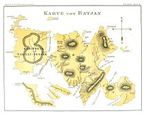
The Sultanate of Bacan was a state in Maluku Islands, present-day Indonesia that arose with the expansion of the spice trade in late medieval times. It mainly consisted of the Bacan Islands but had periodical influence in Ceram and the Papuan Islands. It fell under the colonial influence of Portugal in the 16th century and the Dutch East India Company (VOC) after 1609. Bacan was one of the four kingdoms of Maluku together with Ternate, Tidore and Jailolo, but tended to be overshadowed by Ternate. After the independence of Indonesia in 1949, the governing functions of the sultan were gradually replaced by a modern administrative structure. However, the sultanate has been revived as a cultural entity in present times.

<span class="mw-page-title-main">North Halmahera Regency</span> Regency in North Maluku, Indonesia

North Halmahera Regency is a regency of North Maluku Province, Indonesia. It was declared a Regency on 31 May 2003, formed from part of the former North Maluku Regency. The capital town of the regency lies at the port of Tobelo. The Regency, which has been considerably reduced by the separation of Tidore and of Morotai Island, now covers an area of 3,891.62 square kilometres (1,502.56 sq mi) and had a population of 161,847 people at the 2010 Census, 179,783 at the 2015 Intermediate Census. and 197,640 at the 2020 Census. The official estimate as at mid 2022 was 202,755. The principal settlements are Tobelo, Kao and Galela. The area is noted for its white beaches and coral reefs.

<span class="mw-page-title-main">Galela (city)</span> Town in North Maluku, Indonesia

Galela, is a small town on the eastern Indonesian island of Halmahera. It is located in the North Halmahera Regency, part of the province of North Maluku. Views of Mount Tarakani can be seen from the scenic coast. Galelarese constitutes an official ethnic group in North Halmhera and is also a language, spoken in the Galela region, neighboring parts of Tobelo and Loloda districts, on the island of Morotai and in villages scattered in southern Halmahera as well as on Bacan and Obi. The town borders Lake Galela.

South Halmahera Regency is a regency of North Maluku Province, Indonesia. It lies partly on Halmahera Island and partly on smaller islands to the west and south of Halmahera. It covers a land area of 8,779.32 km2, and at the 2010 Census it had a population of 198,911 people, while the 2020 Census showed that this had risen to 248,395 and the official estimate in mid 2022 was 253,331. The capital lies at the town of Labuha on Bacan Island.

<span class="mw-page-title-main">Labuha</span> Town in Maluku, Indonesia

Labuha is a small port town on the eastern Indonesian island of Pulau Bacan. It is the capital of the South Halmahera Regency, part of the province of North Maluku, and also the administrative centre of the Bacan District within the regency. It has a population at the 2020 Census of 13,546. The town is served by Labuha Airport.

<span class="mw-page-title-main">Kayoa</span> Island in Maluku, Indonesia

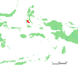
Kayoa, or in the native language Pulau Urimatiti, is a group of 66 islands, part of the Maluku Islands. It is located in South Halmahera Regency, part of North Maluku Province of Indonesia.

Bacan Malay or Bacan is a Malayic language spoken on the island of Bacan in North Maluku province, Indonesia, by the minor Bacan ethnic group. It is an anomalous presence in the region, being surrounded by genetically distant Austronesian languages and languages of the unrelated North Halmahera family. Bacan is geographically removed from the Malay heartlands in the western archipelago.

<span class="mw-page-title-main">Babullah of Ternate</span> Sultan of Ternate

Sultan Babullah, also known as Sultan Baabullah was the 7th Sultan and 24th ruler of the Sultanate of Ternate in Maluku who ruled between 1570 and 1583. He is known as the greatest Sultan in Ternatan and Moluccan history, who defeated the Portuguese occupants in Ternate and led the Sultanate to a golden peak at the end of the 16th century. Sultan Babullah was commonly known as the Ruler of 72 (Inhabited) Islands in eastern Indonesia, including most of the Maluku Islands, Sangihe and parts of Sulawesi, with influences as far as Solor, East Sumbawa, Mindanao, and the Papuan Islands. His reign inaugurated a period of free trade in the spices and forest products that gave Maluku a significant role in Asian commerce.

Sultan Hairun Jamilu was the 6th Muslim ruler of Ternate in Maluku, reigning from 1535 to 1570. During his long reign, he had a shifting relation to the Portuguese who had a stronghold in Ternate and tried to dominate the spice trade in the region. This ended with his assassination at the hands of a Portuguese soldier in 1570.

Mole Majimun was the seventh Sultan of Tidore in Maluku Islands, who reigned from 1599 to 1627. He was also known as Sultan Jumaldin or Kaicili Mole. In his time the transition to the hegemony of the Dutch East India Company (VOC) began in eastern Indonesia, though Tidore held on to its traditional alliance with the Spanish Empire.

<span class="mw-page-title-main">Ternatean–Portuguese conflicts</span> Colonial war in the Spice Islands

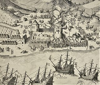
The Ternatean–Portuguese conflicts were a series of conflicts in the Spice Islands in eastern Indonesia between the Portuguese and their allies on one hand, and the Sultanate of Ternate and its allies, on the other. Hostilities broke out from time to time after the establishment of Portugal in Moluccas in 1522. The strongly Catholic and Muslim identities of the combatants gave the struggle elements of a war of religion, although this aspect was frequently blurred by cross-faith alliances. It was also an economic war since the Portuguese aim was to control export of the profitable trade in cloves. Portuguese-Ternatan rivalry later merged with attempts of expansion by the Spanish in the Philippines. The Portuguese were eventually defeated in 1605 by an alliance between the Dutch East India Company (VOC) and Ternate, ending their active involvement in Moluccas affairs. However, they were soon replaced by the Spanish who maintained an Iberian presence in the region up to 1663.

References