
Fort Benton is a city in and the county seat of Chouteau County, Montana, United States. Established in 1846, Fort Benton is the oldest continuously occupied settlement in Montana. Fort Benton was the most upstream navigable port on the Mississippi River System, and is considered "the world’s innermost port".

Saparua is an island east of Ambon Island in the Indonesian province of Maluku; the island of Haruku lies between Saparua and Ambon. The main port is in the south at Kota Saparua. The island of Maolana is located near its southwestern side and Nusa Laut off its southeastern tip.

Pieter Bleeker was a Dutch medical doctor, ichthyologist, and herpetologist. He was famous for the Atlas Ichthyologique des Indes Orientales Néêrlandaises, his monumental work on the fishes of East Asia published between 1862 and 1877.

Maluku is a province of Indonesia. It comprises the central and southern regions of the Maluku Islands. The largest city and capital of Maluku province is Ambon on the small Ambon Island. It is directly adjacent to North Maluku, Southwest Papua, and West Papua in the north, Central Sulawesi, and Southeast Sulawesi in the west, Banda Sea, Australia, East Timor and East Nusa Tenggara in the south and Arafura Sea, Central Papua and South Papua in the east. The land area is 46,150.92 km2, and the total population of this province at the 2010 census was 1,533,506 people, rising to 1,848,923 at the 2020 census, the official estimate as at mid 2022 was 1,881,727. Maluku is located in Eastern Indonesia.
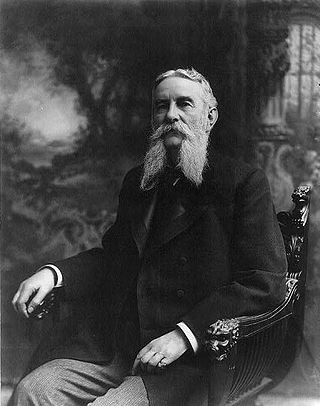
John Grimes Walker was an admiral in the United States Navy who served during the Civil War. After the war, he served as Chief of the Bureau of Navigation, head of the Lighthouse Board, and commander-in-chief of the Squadron of Evolution and of the North Atlantic Squadron. In retirement, he led commissions to investigate the construction of a Central American canal connecting the Atlantic and Pacific Oceans.

Marjane is a Moroccan hypermarket chain. It is wholly owned by Al Mada holding company. The chain opened its first supermarket, in 1990, in Rabat.
Paperu, Indonesia, is a village on the island of Saparua, which is a part of the Ambon island group in the Maluku Islands.

Thomas Matulessy, also known as Kapitan Pattimura or simply Pattimura, was a famous Ambonese soldier who became a symbol of both the Maluku and Indonesian struggle for independence, praised by President Sukarno and declared a national hero by President Suharto. He has several namesakes in both the Netherlands and in the Indonesian archipelago.

The Roman Catholic Archdiocese of Ende is a Latin metropolitan archdiocese in the Lesser Sunda Islands, Indonesia.

Australasia is a subregion of Oceania, comprising Australia, New Zealand and some neighbouring islands in the Pacific Ocean. The term is used in a number of different contexts, including geopolitically, physiogeographically, philologically, and ecologically, where the term covers several slightly different but related regions.

Martha Christina Tiahahu was a Moluccan freedom fighter and National Heroine of Indonesia.

Haruku Island is an island in Central Maluku Regency, Maluku Province, Indonesia - lying east of Ambon Island, off the southern coast of Seram and just west of Saparua. It is administered as a single district, Haruku Island District, with a land area of 150 km2 and a population of 24,207 at the 2010 census and 27,390 at the 2020 Census; the official estimate as at mid 2022 was 27,409. The inhabitants of Haruku speak the Haruku language, as well as Indonesian and Ambonese Malay.

The Lease Islands, formerly called the Uliasers or Uliassers, are a group of three inhabited islands, lying immediately to the south of Seram and east of Ambon Island in the province of Maluku, in Indonesia. The three inhabited islands, from west to east, are Haruku, Saparua and Nusa Laut, while tiny uninhabited Molana is administratively part of Saparua District; these islands constitute four administrative districts (kecamatan) within Central Maluku Regency.

Baia Mare Metropolitan Area (BMMA) is located in northwestern Romania and consists of Baia Mare City and localities found within a distance of 35 km.

Ambon was a governorate of the Dutch East India Company, consisting of Ambon Island and ten neighbouring islands. Steven van der Hagen captured Fort Victoria on 22 February 1605 from the Portuguese in the name of the Dutch East India Company. Until 1619, Ambon served as the capital of the Dutch possessions in East Asia. In that year Batavia was founded to function as the staple port for the Dutch East India Company in Asia. The island was the world center of clove production until the 19th century. The Dutch prohibited the rearing of the clove-tree in all the other islands subject to their rule, in order to secure the monopoly to Ambon.
Haria is one of the 17 villages on the island of Saparua, Maluku, Indonesia.

Manipa Island is an island in West Seram Regency, Maluku Province, Indonesia. It is located 8 km off the western coast of Kelang at the western end of Seram Island and 25 km off the western coast of Buru. Including adjacent small islands, it covers an area of 159.71 km2. The inhabitants speak the Manipa language, as well as Indonesian and Ambonese Malay.

Fort Amsterdam is a fort and a blockhouse in Hila town, Leihitu Subdistrict, Central Maluku Regency, Ambon Island, Indonesia. The blockhouse was built in 1637 by the Dutch East Indies Company.
The 1852 Banda Sea earthquake struck on 26 November at 07:40 local time, affecting coastal communities on the Banda Islands. It caused violent shaking lasting five minutes, and was assigned XI on the Modified Mercalli intensity scale in the Maluku Islands. A tsunami measuring up to 8 m (26 ft) slammed into the islands of Banda Neira, Saparua, Haruku and Ceram. The tsunami caused major damage, washing away many villages, ships and residents. At least 60 people were killed in the earthquake and tsunami. The earthquake had an estimated moment magnitude of 7.5 or 8.4–8.8, according to various academic studies.


