The Devonian is a geologic period and system of the Paleozoic era, spanning 60.3 million years from the end of the Silurian, 419.2 million years ago (Ma), to the beginning of the Carboniferous, 358.9 Ma. It is named after Devon, England, where rocks from this period were first studied.

Laurasia was the more northern of two large landmasses that formed part of the Pangaea supercontinent from around 335 to 175 million years ago (Mya), the other being Gondwana. It separated from Gondwana 215 to 175 Mya during the breakup of Pangaea, drifting farther north after the split and finally broke apart with the opening of the North Atlantic Ocean c. 56 Mya. The name is a portmanteau of Laurentia and Asia.

Avalonia was a microcontinent in the Paleozoic era. Crustal fragments of this former microcontinent underlie south-west Great Britain, southern Ireland, and the eastern coast of North America. It is the source of many of the older rocks of Western Europe, Atlantic Canada, and parts of the coastal United States. Avalonia is named for the Avalon Peninsula in Newfoundland.

The Caledonian orogeny was a mountain-building era recorded in the northern parts of the British Isles, the Scandinavian Mountains, Svalbard, eastern Greenland and parts of north-central Europe. The Caledonian orogeny encompasses events that occurred from the Ordovician to Early Devonian, roughly 490–390 million years ago (Ma). It was caused by the closure of the Iapetus Ocean when the continents and terranes of Laurentia, Baltica and Avalonia collided.

The Variscan or Hercynianorogeny was a geologic mountain-building event caused by Late Paleozoic continental collision between Euramerica (Laurussia) and Gondwana to form the supercontinent of Pangaea.
The Uralian orogeny refers to the long series of linear deformation and mountain building events that raised the Ural Mountains, starting in the Late Carboniferous and Permian periods of the Palaeozoic Era, c. 323–299 and 299–251 million years ago (Mya) respectively, and ending with the last series of continental collisions in Triassic to early Jurassic times.
The Rheic Ocean was an ocean which separated two major palaeocontinents, Gondwana and Laurussia (Laurentia-Baltica-Avalonia). One of the principal oceans of the Palaeozoic, its sutures today stretch 10,000 km (6,200 mi) from Mexico to Turkey and its closure resulted in the assembly of the supercontinent Pangaea and the formation of the Variscan–Alleghenian–Ouachita orogenies.

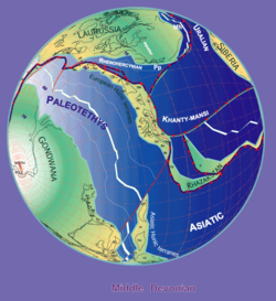
The Paleo-Tethys or Palaeo-Tethys Ocean was an ocean located along the northern margin of the paleocontinent Gondwana that started to open during the Middle Cambrian, grew throughout the Paleozoic, and finally closed during the Late Triassic; existing for about 400 million years.
The Proto-Tethys or Theic Ocean was an ancient ocean that existed from the latest Ediacaran to the Carboniferous.
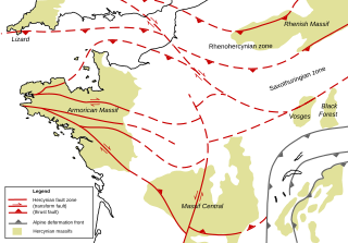
The Armorican Massif is a geologic massif that covers a large area in the northwest of France, including Brittany, the western part of Normandy and the Pays de la Loire. It is important because it is connected to Dover on the British side of the English Channel and there has been tilting back and forth that has controlled the geography on both sides.

Gondwana was a large landmass, sometimes referred to as a supercontinent. It was formed by the accretion of several cratons, beginning c. 800 to 650Ma with the East African Orogeny, the collision of India and Madagascar with East Africa, and was completed c.600 to 530 Ma with the overlapping Brasiliano and Kuunga orogenies, the collision of South America with Africa, and the addition of Australia and Antarctica, respectively. Eventually, Gondwana became the largest piece of continental crust of the Palaeozoic Era, covering an area of about 100,000,000 km2 (39,000,000 sq mi), about one-fifth of the Earth's surface. It fused with Euramerica during the Carboniferous to form Pangea. It began to separate from northern Pangea (Laurasia) during the Triassic, and started to fragment during the Early Jurassic. The final stages of break-up, involving the separation of Antarctica from South America and Australia, occurred during the Paleogene (from around 66 to 23 million years ago. Gondwana was not considered a supercontinent by the earliest definition, since the landmasses of Baltica, Laurentia, and Siberia were separated from it. To differentiate it from the Indian region of the same name, it is also commonly called Gondwanaland.

The Rhenohercynian Zone or Rheno-Hercynian zone in structural geology describes a fold belt of west and central Europe, formed during the Hercynian orogeny. The zone consists of folded and thrust Devonian and early Carboniferous sedimentary rocks that were deposited in a back-arc basin along the southern margin of the then existing paleocontinent Laurussia.
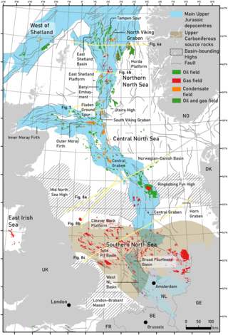
The geology of the North Sea describes the geological features such as channels, trenches, and ridges today and the geological history, plate tectonics, and geological events that created them.
The Saxothuringian Zone, Saxo-Thuringian zone or Saxothuringicum is in geology a structural or tectonic zone in the Hercynian or Variscan orogen of central and western Europe. Because rocks of Hercynian age are in most places covered by younger strata, the zone is not everywhere visible at the surface. Places where it crops out are the northern Bohemian Massif, the Spessart, the Odenwald, the northern parts of the Black Forest and Vosges and the southern part of the Taunus. West of the Vosges terranes on both sides of the English Channel are also seen as part of the zone, for example the Lizard complex in Cornwall or the Léon Zone of the Armorican Massif (Brittany).
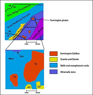
The Carolina Terrane, also called the Carolina Superterrane or Carolinia, is an exotic terrane running ~370 miles (600 km) approximately North-South from central Georgia to central Virginia in the United States. It constitutes a major part of the eastern Piedmont Province.

The Bohemian Massif is a geomorphological province in Central Europe. It is a large massif stretching over most of the Czech Republic, eastern Germany, southern Poland and northern Austria.
The Moldanubian Zone is in the regional geology of Europe a tectonic zone formed during the Variscan or Hercynian Orogeny. The Moldanubian Zone crops out in the Bohemian Massif and the southern part of the Black Forest and Vosges and contains the highest grade metamorphic rocks of Variscan age in Europe.
The Massif Central is one of the two large basement massifs in France, the other being the Armorican Massif. The Massif Central's geological evolution started in the late Neoproterozoic and continues to this day. It has been shaped mainly by the Caledonian orogeny and the Variscan orogeny. The Alpine orogeny has also left its imprints, probably causing the important Cenozoic volcanism. The Massif Central has a very long geological history, underlined by zircon ages dating back into the Archaean 3 billion years ago. Structurally it consists mainly of stacked metamorphic basement nappes.

Patagonia comprises the southernmost region of South America, portions of which lie on either side of the Argentina-Chile border. It has traditionally been described as the region south of the Rio Colorado, although the physiographic border has more recently been moved southward to the Huincul fault. The region's geologic border to the north is composed of the Rio de la Plata craton and several accreted terranes comprising the La Pampa province. The underlying basement rocks of the Patagonian region can be subdivided into two large massifs: the North Patagonian Massif and the Deseado Massif. These massifs are surrounded by sedimentary basins formed in the Mesozoic that underwent subsequent deformation during the Andean orogeny. Patagonia is known for its vast earthquakes and the damage they cause.
The Hunic superterrane is a terrane that is now attached to Europe and Asia. At the end of the Ordovician or beginning of the Silurian it separated from Gondwana and joined Laurasia at the beginning of the Carboniferous, at the time of the Variscan orogeny. Rather than being a single block, there were apparently two groups of blocks, the European Hunic terranes and the Asian Hunic terranes.