Orogeny is a mountain-building process that takes place at a convergent plate margin when plate motion compresses the margin. An orogenic belt or orogen develops as the compressed plate crumples and is uplifted to form one or more mountain ranges. This involves a series of geological processes collectively called orogenesis. These include both structural deformation of existing continental crust and the creation of new continental crust through volcanism. Magma rising in the orogen carries less dense material upwards while leaving more dense material behind, resulting in compositional differentiation of Earth's lithosphere. A synorogenic process or event is one that occurs during an orogeny.
Obduction is a geological process whereby denser oceanic crust is scraped off a descending ocean plate at a convergent plate boundary and thrust on top of an adjacent plate. When oceanic and continental plates converge, normally the denser oceanic crust sinks under the continental crust in the process of subduction. Obduction, which is less common, normally occurs in plate collisions at orogenic belts or back-arc basins.

Sedimentary basins are region-scale depressions of the Earth's crust where subsidence has occurred and a thick sequence of sediments have accumulated to form a large three-dimensional body of sedimentary rock. They form when long-term subsidence creates a regional depression that provides accommodation space for accumulation of sediments. Over millions or tens or hundreds of millions of years the deposition of sediment, primarily gravity-driven transportation of water-borne eroded material, acts to fill the depression. As the sediments are buried, they are subject to increasing pressure and begin the processes of compaction and lithification that transform them into sedimentary rock.

A convergent boundary is an area on Earth where two or more lithospheric plates collide. One plate eventually slides beneath the other, a process known as subduction. The subduction zone can be defined by a plane where many earthquakes occur, called the Wadati–Benioff zone. These collisions happen on scales of millions to tens of millions of years and can lead to volcanism, earthquakes, orogenesis, destruction of lithosphere, and deformation. Convergent boundaries occur between oceanic-oceanic lithosphere, oceanic-continental lithosphere, and continental-continental lithosphere. The geologic features related to convergent boundaries vary depending on crust types.

The African Plate, also known as the Nubian Plate, is a major tectonic plate that includes much of the continent of Africa and the adjacent oceanic crust to the west and south. It is bounded by the North American Plate and South American Plate to the west ; the Arabian Plate and Somali Plate to the east; the Eurasian Plate, Aegean Sea Plate and Anatolian Plate to the north; and the Antarctic Plate to the south.

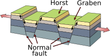
In geology, a rift is a linear zone where the lithosphere is being pulled apart and is an example of extensional tectonics. Typical rift features are a central linear downfaulted depression, called a graben, or more commonly a half-graben with normal faulting and rift-flank uplifts mainly on one side. Where rifts remain above sea level they form a rift valley, which may be filled by water forming a rift lake. The axis of the rift area may contain volcanic rocks, and active volcanism is a part of many, but not all, active rift systems.

The Sevier orogeny was a mountain-building event that affected western North America from northern Canada to the north to Mexico to the south.

A passive margin is the transition between oceanic and continental lithosphere that is not an active plate margin. A passive margin forms by sedimentation above an ancient rift, now marked by transitional lithosphere. Continental rifting forms new ocean basins. Eventually the continental rift forms a mid-ocean ridge and the locus of extension moves away from the continent-ocean boundary. The transition between the continental and oceanic lithosphere that was originally formed by rifting is known as a passive margin.

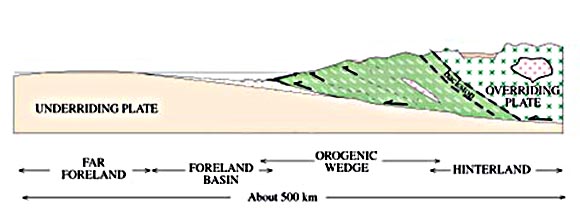
A foreland basin is a structural basin that develops adjacent and parallel to a mountain belt. Foreland basins form because the immense mass created by crustal thickening associated with the evolution of a mountain belt causes the lithosphere to bend, by a process known as lithospheric flexure. The width and depth of the foreland basin is determined by the flexural rigidity of the underlying lithosphere, and the characteristics of the mountain belt. The foreland basin receives sediment that is eroded off the adjacent mountain belt, filling with thick sedimentary successions that thin away from the mountain belt. Foreland basins represent an endmember basin type, the other being rift basins. Space for sediments is provided by loading and downflexure to form foreland basins, in contrast to rift basins, where accommodation space is generated by lithospheric extension.

The North China Craton is a continental crustal block with one of Earth's most complete and complex records of igneous, sedimentary and metamorphic processes. It is located in northeast China, Inner Mongolia, the Yellow Sea, and North Korea. The term craton designates this as a piece of continent that is stable, buoyant and rigid. Basic properties of the cratonic crust include being thick, relatively cold when compared to other regions, and low density. The North China Craton is an ancient craton, which experienced a long period of stability and fitted the definition of a craton well. However, the North China Craton later experienced destruction of some of its deeper parts (decratonization), which means that this piece of continent is no longer as stable.
The Alice Springs Orogeny was a major intraplate tectonic episode in central Australia responsible for the formation of a series of large mountain ranges. The deformation associated with the Alice Spring Orogeny caused the vertically-tilted sandstone layers of the iconic Uluru/Ayers Rock.

In geology, a forebulge is a flexural bulge in front as a result of a load on the lithosphere, often caused by tectonic interactions and glaciations. An example of forebulge can be seen in the Himalayan foreland basin, a result of the Indian-Eurasian (continent-continent) plate collision, in which the Indian plate subducted and the Eurasian plate created a large load on the lithosphere, leading to the Himalayas and the Ganges foreland basin.

The Gibraltar Arc is a geological region corresponding to an arcuate orogen surrounding the Alboran Sea, between the Iberian Peninsula and Africa. It consists of the Betic Cordillera, and the Rif. The Gibraltar Arc is located at the western end of the Mediterranean Alpine belt and formed during the Neogene due to convergence of the Eurasian and African plates.
Non-volcanic passive margins (NVPM) constitute one end member of the transitional crustal types that lie beneath passive continental margins; the other end member being volcanic passive margins (VPM). Transitional crust welds continental crust to oceanic crust along the lines of continental break-up. Both VPM and NVPM form during rifting, when a continent rifts to form a new ocean basin. NVPM are different from VPM because of a lack of volcanism. Instead of intrusive magmatic structures, the transitional crust is composed of stretched continental crust and exhumed upper mantle. NVPM are typically submerged and buried beneath thick sediments, so they must be studied using geophysical techniques or drilling. NVPM have diagnostic seismic, gravity, and magnetic characteristics that can be used to distinguish them from VPM and for demarcating the transition between continental and oceanic crust.
Volcanic passive margins (VPM) and non-volcanic passive margins are the two forms of transitional crust that lie beneath passive continental margins that occur on Earth as the result of the formation of ocean basins via continental rifting. Initiation of igneous processes associated with volcanic passive margins occurs before and/or during the rifting process depending on the cause of rifting. There are two accepted models for VPM formation: hotspots/mantle plumes and slab pull. Both result in large, quick lava flows over a relatively short period of geologic time. VPM's progress further as cooling and subsidence begins as the margins give way to formation of normal oceanic crust from the widening rifts.
A half-graben is a geological structure bounded by a fault along one side of its boundaries, unlike a full graben where a depressed block of land is bordered by parallel faults.

The North Sea is part of the Atlantic Ocean in northern Europe. It is located between Norway and Denmark in the east, Scotland and England in the west, Germany, the Netherlands, Belgium and France in the south.

The North German Basin is a passive-active rift basin located in central and west Europe, lying within the southeasternmost portions of the North Sea and the southwestern Baltic Sea and across terrestrial portions of northern Germany, Netherlands, and Poland. The North German Basin is a sub-basin of the Southern Permian Basin, that accounts for a composite of intra-continental basins composed of Permian to Cenozoic sediments, which have accumulated to thicknesses around 10–12 kilometres (6–7.5 mi). The complex evolution of the basin takes place from the Permian to the Cenozoic, and is largely influenced by multiple stages of rifting, subsidence, and salt tectonic events. The North German Basin also accounts for a significant amount of Western Europe's natural gas resources, including one of the world's largest natural gas reservoir, the Groningen gas field.
The geology of Sicily records the collision of the Eurasian and the African plates during westward-dipping subduction of the African slab since late Oligocene. Major tectonic units are the Hyblean foreland, the Gela foredeep, the Apenninic-Maghrebian orogen, and the Calabrian Arc. The orogen represents a fold-thrust belt that folds Mesozoic carbonates, while a major volcanic unit is found in an eastern portion of the island. The collision of Africa and Eurasia is a retreating subduction system, such that the descending Africa is falling away from Eurasia, and Eurasia extends and fills the space as the African plate falls into the mantle, resulting in volcanic activity in Sicily and the formation of Tyrrhenian slab to the north.

The Junggar Basin, also known as the Dzungarian Basin or Zungarian Basin, is one of the largest sedimentary basins in Northwest China. It is located in Dzungaria in northern Xinjiang, and enclosed by the Tarbagatai Mountains of Kazakhstan in the northwest, the Altai Mountains of Mongolia in the northeast, and the Heavenly Mountains in the south. The geology of Junggar Basin mainly consists of sedimentary rocks underlain by igneous and metamorphic basement rocks. The basement of the basin was largely formed during the development of the Pangea supercontinent during complex tectonic events from Precambrian to late Paleozoic time. The basin developed as a series of foreland basins – in other words, basins developing immediately in front of growing mountain ranges – from Permian time to the Quaternary period. The basin's preserved sedimentary records show that the climate during the Mesozoic era was marked by a transition from humid to arid conditions as monsoonal climatic effects waned. The Junggar basin is rich in geological resources due to effects of volcanism and sedimentary deposition. According to Guinness World Records it is a land location remotest from open sea with great-circle distance of 2,648 km from the nearest open sea at 46°16′8″N86°40′2″E.