The geology of Illinois includes extensive deposits of marine sedimentary rocks from the Palaeozoic, as well as relatively minor contributions from the Mesozoic and Cenozoic. Ice age glaciation left a wealth of glacial topographic features throughout the state.
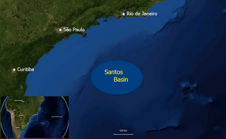
The Santos Basin is an approximately 352,000 square kilometres (136,000 sq mi) large mostly offshore sedimentary basin. It is located in the south Atlantic Ocean, some 300 kilometres (190 mi) southeast of Santos, Brazil. The basin is one of the Brazilian basins to have resulted from the break-up of Gondwana since the Early Cretaceous, where a sequence of rift basins formed on both sides of the South Atlantic; the Pelotas, Santos, Campos and Espírito Santo Basins in Brazil, and the Namibia, Kwanza and Congo Basins in southwestern Africa.

West Virginia's geologic history stretches back into the Precambrian, and includes several periods of mountain building and erosion. At times, much of what is now West Virginia was covered by swamps, marshlands, and shallow seas, accounting for the wide variety of sedimentary rocks found in the state, as well as its wealth of coal and natural gas deposits. West Virginia has had no active volcanism for hundreds of millions of years, and does not experience large earthquakes, although smaller tremors are associated with the Rome Trough, which passes through the western part of the state.
The geology of the Baltic Sea is characterized by having areas located both at the Baltic Shield of the East European Craton and in the Danish-North German-Polish Caledonides. Historical geologists make a distinction between the current Baltic Sea depression, formed in the Cenozoic era, and the much older sedimentary basins whose sediments are preserved in the zone. Although glacial erosion has contributed to shape the present depression, the Baltic trough is largely a depression of tectonic origin that existed long before the Quaternary glaciation.
The geology of Western Sahara includes rock units dating back to the Archean more than two billion years old, although deposits of phosphorus formed in the Mesozoic and Cenozoic have helped to prompt the current Moroccan occupation of most of the country.
The geology of Mauritania is built on more than two billion year old Archean crystalline basement rock in the Reguibat Shield of the West African Craton, a section of ancient and stable continental crust. Mobile belts and the large Taoudeni Basin formed and filled with sediments in the connection with the Pan-African orogeny mountain building event 600 million years ago and a subsequent orogeny created the Mauritanide Belt. In the last 251 million years, Mauritania has accumulated additional sedimentary rocks during periods of marine transgression and sea level retreat. The arid country is 50% covered in sand dunes and has extensive mineral resources, although iron plays the most important role in the economy.
The geology of Morocco formed beginning up to two billion years ago, in the Paleoproterozoic and potentially even earlier. It was affected by the Pan-African orogeny, although the later Hercynian orogeny produced fewer changes and left the Maseta Domain, a large area of remnant Paleozoic massifs. During the Paleozoic, extensive sedimentary deposits preserved marine fossils. Throughout the Mesozoic, the rifting apart of Pangaea to form the Atlantic Ocean created basins and fault blocks, which were blanketed in terrestrial and marine sediments—particularly as a major marine transgression flooded much of the region. In the Cenozoic, a microcontinent covered in sedimentary rocks from the Triassic and Cretaceous collided with northern Morocco, forming the Rif region. Morocco has extensive phosphate and salt reserves, as well as resources such as lead, zinc, copper and silver.
The geology of Ohio formed beginning more than one billion years ago in the Proterozoic eon of the Precambrian. The igneous and metamorphic crystalline basement rock is poorly understood except through deep boreholes and does not outcrop at the surface. The basement rock is divided between the Grenville Province and Superior Province. When the Grenville Province crust collided with Proto-North America, it launched the Grenville orogeny, a major mountain building event. The Grenville mountains eroded, filling in rift basins and Ohio was flooded and periodically exposed as dry land throughout the Paleozoic. In addition to marine carbonates such as limestone and dolomite, large deposits of shale and sandstone formed as subsequent mountain building events such as the Taconic orogeny and Acadian orogeny led to additional sediment deposition. Ohio transitioned to dryland conditions in the Pennsylvanian, forming large coal swamps and the region has been dryland ever since. Until the Pleistocene glaciations erased these features, the landscape was cut with deep stream valleys, which scoured away hundreds of meters of rock leaving little trace of geologic history in the Mesozoic and Cenozoic.
The geology of Arizona began to form in the Precambrian. Igneous and metamorphic crystalline basement rock may have been much older, but was overwritten during the Yavapai and Mazatzal orogenies in the Proterozoic. The Grenville orogeny to the east caused Arizona to fill with sediments, shedding into a shallow sea. Limestone formed in the sea was metamorphosed by mafic intrusions. The Great Unconformity is a famous gap in the stratigraphic record, as Arizona experienced 900 million years of terrestrial conditions, except in isolated basins. The region oscillated between terrestrial and shallow ocean conditions during the Paleozoic as multi-cellular life became common and three major orogenies to the east shed sediments before North America became part of the supercontinent Pangaea. The breakup of Pangaea was accompanied by the subduction of the Farallon Plate, which drove volcanism during the Nevadan orogeny and the Sevier orogeny in the Mesozoic, which covered much of Arizona in volcanic debris and sediments. The Mid-Tertiary ignimbrite flare-up created smaller mountain ranges with extensive ash and lava in the Cenozoic, followed by the sinking of the Farallon slab in the mantle throughout the past 14 million years, which has created the Basin and Range Province. Arizona has extensive mineralization in veins, due to hydrothermal fluids and is notable for copper-gold porphyry, lead, zinc, rare minerals formed from copper enrichment and evaporites among other resources.
The geology of Estonia is the study of rocks, minerals, water, landforms and geologic history in Estonia. The crust is part of the East European Craton and formed beginning in the Paleoproterozoic nearly two billion years ago. Shallow marine environments predominated in Estonia, producing extensive natural resources from organic matter such as oil shale and phosphorite. The Mesozoic and much of the Cenozoic are not well-preserved in the rock record, although the glaciations during the Pleistocene buried deep valleys in sediment, rechanneled streams and left a landscape of extensive lakes and peat bogs.
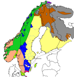
The geology of Sweden is the regional study of rocks, minerals, tectonics, natural resources and groundwater in the country. The oldest rocks in Sweden date to more than 2.5 billion years ago in the Precambrian. Complex orogeny mountain building events and other tectonic occurrences built up extensive metamorphic crystalline basement rock that often contains valuable metal deposits throughout much of the country. Metamorphism continued into the Paleozoic after the Snowball Earth glaciation as the continent Baltica collided with an island arc and then the continent Laurentia. Sedimentary rocks are most common in southern Sweden with thick sequences from the last 250 million years underlying Malmö and older marine sedimentary rocks forming the surface of Gotland.
The geology of Nunavut began to form nearly three billion years ago in the Archean and the territory preserves some of the world's oldest rock units.
The geology of Utah includes rocks formed at the edge of the proto-North American continent during the Precambrian. A shallow marine sedimentary environment covered the region for much of the Paleozoic and Mesozoic, followed by dryland conditions, volcanism and the formation of the basin and range terrain in the Cenozoic. Utah is a state in the western United States.
The geology of North Dakota includes thick sequences oil and coal bearing sedimentary rocks formed in shallow seas in the Paleozoic and Mesozoic, as well as terrestrial deposits from the Cenozoic on top of ancient Precambrian crystalline basement rocks. The state has extensive oil and gas, sand and gravel, coal, groundwater and other natural resources.

The geology of Uzbekistan consists of two microcontinents and the remnants of oceanic crust, which fused together into a tectonically complex but resource rich land mass during the Paleozoic, before becoming draped in thick, primarily marine sedimentary units.
The geology of Thailand includes deep crystalline metamorphic basement rocks, overlain by extensive sandstone, limestone, turbidites and some volcanic rocks. The region experienced complicated tectonics during the Paleozoic, long-running shallow water conditions and then renewed uplift and erosion in the past several million years ago.
Geology of Latvia includes an ancient Archean and Proterozoic crystalline basement overlain with Neoproterozoic volcanic rocks and numerous sedimentary rock sequences from the Paleozoic, some from the Mesozoic and many from the recent Quaternary past. Latvia is a country in the Baltic region of Northern Europe.
The geology of Denmark includes 12 kilometers of unmetamorphosed sediments lie atop the Precambrian Fennoscandian Shield, the Norwegian-Scottish Caledonides and buried North German-Polish Caledonides. The stable Fennoscandian Shield formed from 1.45 billion years ago to 850 million years ago in the Proterozoic. The Fennoscandian Border Zone is a large fault, bounding the deep basement rock of the Danish Basin—a trough between the Border Zone and the Ringkobing-Fyn High. The Sorgenfrei-Tornquist Zone is a fault-bounded area displaying Cretaceous-Cenozoic inversion.
The geology of Argentina includes ancient Precambrian basement rock affected by the Grenville orogeny, sediment filled basins from the Mesozoic and Cenozoic as well as newly uplifted areas in the Andes.
The geology of Yukon includes sections of ancient Precambrian Proterozoic rock from the western edge of the proto-North American continent Laurentia, with several different island arc terranes added through the Paleozoic, Mesozoic and Cenozoic, driving volcanism, pluton formation and sedimentation.
