Kvamshesten Basin | |
---|---|
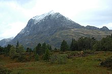
The mountain of Kvamshesten (Storehesten), formed of Devonian conglomerates and sandstones above a sharp tectonic contact with mylonites of the Nordfjord-Sogn Detachment | |
Geological map of the Kvamshesten Basin | |
Coordinates | 61°25′N5°33′E / 61.41°N 5.55°E Coordinates: 61°25′N5°33′E / 61.41°N 5.55°E |
Etymology | Kvamshesten |
Region | Vestland |
Country | Norway |
Characteristics | |
On/Offshore | Onshore |
Area | 75 km2 (29 sq mi) |
Geology | |
Age | Devonian |
Faults | Kvamshesten Detachment/Dalsfjord Fault |
The Kvamshesten Basin is a sedimentary basin containing coarse continental clastic rocks of Devonian age. It is one of a series of basins of similar age in southwestern Norway found between Sognefjord and Nordfjord, developed in the hanging-wall of the Nordfjord-Sogn Detachment. [1] It is named for the mountain of Kvamshesten.
During the later part of the Silurian period, the western margin of the Baltic Plate was affected by the main collisional event of the Caledonian orogeny, known as the Scandian phase. This led to large-scale thrusting and the development of a mountain belt similar in scale to the Himalayas. Soon after the collision finished during the Early Devonian, the thickened crust began to extend. Initially the extension took place by reactivation of Caledonian thrust faults, known as Mode 1 extension. The uplift and exhumation led to a reduction of dip in these reactivated thrusts, making them progressively less mechanically viable. At this point Mode II extension took over, with development of large extensional shear zones that cross-cut the Caledonian thrust pile, such as the Nordfjord-Sogn Detachment. [1]
The northern margin of the basin is dominated by conglomerates and breccias deposited by alluvial fans. The southern margin is mainly conglomerate, while with the central axis of the basin is mainly sandstone. Between the marginal conglomerates/breccias and the axial sandstones, finer-grained sequences are locally developed consisting of mudstone, siltstone and fine-grained conglomerate. [2]
The overall dip of the Devonian sequence is to the east towards the tectonic contact with the Dalsfjord Fault (Kvamshesten Detachment). The whole sequence, the basement units beneath the unconformable contacts towards the western end of the basin, the detachment and the underlying highly deformed rocks of the shear zone formed by the Nordfjord-Sogn Detachment have a synclinal geometry, indicating north–south shortening. [2]
The Devonian rocks are cut by a series of high-angle faults, most of them extensional in type with evidence of being active during sedimentation. These faults are confined to the hanging-wall of the underlying detachment fault. Some of these earlier extensional structures show evidence of reactivation as reverse faults. [2]
Both the timing and the cause of the observed north–south shortening is uncertain. Suggestions that the shortening happened at the same time as the extension along the detachment, have been countered by there being no evidence of changes in the tightness of the folding with stratigraphic level and a lack of unconformities within the basin fill. [2]
An orogeny is an event that leads to both structural deformation and compositional differentiation of the Earth's lithosphere at convergent plate margins. An orogen or orogenic belt develops when a continental plate crumples and is pushed upwards to form one or more mountain ranges; this involves a series of geological processes collectively called orogenesis.
In geology, a fault is a planar fracture or discontinuity in a volume of rock across which there has been significant displacement as a result of rock-mass movement. Large faults within the Earth's crust result from the action of plate tectonic forces, with the largest forming the boundaries between the plates, such as subduction zones or transform faults. Energy release associated with rapid movement on active faults is the cause of most earthquakes. Faults may also displace slowly, by aseismic creep.
In structural geology, a fold is a stack of originally planar surfaces, such as sedimentary strata, that are bent or curved during permanent deformation. Folds in rocks vary in size from microscopic crinkles to mountain-sized folds. They occur as single isolated folds or in periodic sets. Synsedimentary folds are those formed during sedimentary deposition.
The Antler orogeny was a tectonic event that began in the early Late Devonian with widespread effects continuing into the Mississippian and early Pennsylvanian. Most of the evidence for this event is in Nevada but the limits of its reach are unknown. A great volume of conglomeratic deposits of mainly Mississippian age in Nevada and adjacent areas testifies to the existence of an important tectonic event, and implies nearby areas of uplift and erosion, but the nature and cause of that event are uncertain and in dispute. Although it is known as an orogeny, some of the classic features of orogeny as commonly defined such as metamorphism, and granitic intrusives have not been linked to it. In spite of this, the event is universally designated as an orogeny and that practice is continued here. This article outlines what is known and unknown about the Antler orogeny and describes three current theories regarding its nature and origin.
The Moine Thrust Belt or Moine Thrust Zone is a linear tectonic feature in the Scottish Highlands which runs from Loch Eriboll on the north coast 190 kilometres (120 mi) south-west to the Sleat peninsula on the Isle of Skye. The thrust belt consists of a series of thrust faults that branch off the Moine Thrust itself. Topographically, the belt marks a change from rugged, terraced mountains with steep sides sculptured from weathered igneous, sedimentary and metamorphic rocks in the west to an extensive landscape of rolling hills over a metamorphic rock base to the east. Mountains within the belt display complexly folded and faulted layers and the width of the main part of the zone varies up to 10 kilometres (6.2 mi), although it is significantly wider on Skye.
The Sevier orogeny was a mountain-building event that affected western North America from northern Canada to the north to Mexico to the south.
The geology of Nepal is dominated by the Himalaya, the highest, youngest and a very highly active mountain range. Himalaya is a type locality for the study of on-going continent-continent collision tectonics. The Himalayan arc extends about 2,400 km (1,500 mi) from Nanga Parbat by the Indus River in northern Pakistan eastward to Namche Barwa by the gorge of the Tsangpo-Brahmaputra in eastern Tibet. About 800 km (500 mi) of this extent is in Nepal; the remainder includes Bhutan and parts of Pakistan, India, and China.
Décollement is a gliding plane between two rock masses, also known as a basal detachment fault. Décollements are a deformational structure, resulting in independent styles of deformation in the rocks above and below the fault. They are associated with both compressional settings and extensional settings.
Extensional tectonics is concerned with the structures formed by, and the tectonic processes associated with, the stretching of a planetary body's crust or lithosphere.
Detachment faulting is associated with large-scale extensional tectonics. Detachment faults often have very large displacements and juxtapose unmetamorphosed hanging walls against medium to high-grade metamorphic footwalls that are called metamorphic core complexes. They are thought to have formed as either initially low-angle structures or by the rotation of initially high-angle normal faults modified also by the isostatic effects of tectonic denudation. Examples of detachment faulting include:
The Alice Springs Orogeny was a major intraplate tectonic episode in central Australia responsible for the formation of a series of large mountain ranges. The deformation associated with the Alice Spring Orogeny caused the vertically-tilted sandstone layers of the iconic Uluru/Ayers Rock.
In structural geology inversion or basin inversion relates to the relative uplift of a sedimentary basin or similar structure as a result of crustal shortening. This normally excludes uplift developed in the footwalls of later extensional faults, or uplift caused by mantle plumes. "Inversion" can also refer to individual faults, where an extensional fault is reactivated in the opposite direction to its original movement.
The geology of Norway encompasses the history of earth that can be interpreted by rock types found in Norway, and the associated sedimentological history of soils and rock types.
The Orcadian Basin is a sedimentary basin of Devonian age that formed mainly as a result of extensional tectonics in northeastern Scotland after the end of the Caledonian orogeny. During part of its history, the basin was filled by a lake now known as Lake Orcadie. In that lacustrine environment, a sequence of finely bedded sedimentary rocks was deposited, containing well-preserved fish fossils, with alternating layers of mudstone and coarse siltstone to very fine sandstone. These flagstones split easily along the bedding and have been used as building material for thousands of years. The deposits of the Orcadian Basin form part of the Old Red Sandstone (ORS). The lithostratigraphic terms lower, middle and upper ORS, however, do not necessarily match exactly with sediments of lower, middle and upper Devonian age, as the base of the ORS is now known to be in the Silurian and the top in the Carboniferous.
The Moine Supergroup is a sequence of Neoproterozoic metamorphic rocks that form the dominant outcrop of the Scottish Highlands between the Moine Thrust Belt to the northwest and the Great Glen Fault to the southeast. The sequence is metasedimentary in nature and was metamorphosed and deformed in a series of tectonic events during the Late Proterozoic and Early Paleozoic. It takes its name from A' Mhòine, a peat bog in northern Sutherland.
The Pyrenees are a 430-kilometre-long, roughly east–west striking, intracontinental mountain chain that divide France, Spain, and Andorra. The belt has an extended, polycyclic geological evolution dating back to the Precambrian. The chain's present configuration is due to the collision between the microcontinent Iberia and the southwestern promontory of the European Plate. The two continents were approaching each other since the onset of the Upper Cretaceous (Albian/Cenomanian) about 100 million years ago and were consequently colliding during the Paleogene (Eocene/Oligocene) 55 to 25 million years ago. After its uplift, the chain experienced intense erosion and isostatic readjustments. A cross-section through the chain shows an asymmetric flower-like structure with steeper dips on the French side. The Pyrenees are not solely the result of compressional forces, but also show an important sinistral shearing.
The North Sea basin is located in northern Europe and lies between the United Kingdom, and Norway just north of The Netherlands and can be divided into many sub-basins. The Southern North Sea basin is the largest gas producing basin in the UK continental shelf, with production coming from the lower Permian sandstones which are sealed by the upper Zechstein salt. The evolution of the North Sea basin occurred through multiple stages throughout the geologic timeline. First the creation of the Sub-Cambrian peneplain, followed by the Caledonian Orogeny in the late Silurian and early Devonian. Rift phases occurred in the late Paleozoic and early Mesozoic which allowed the opening of the northeastern Atlantic. Differential uplift occurred in the late Paleogene and Neogene. The geology of the Southern North Sea basin has a complex history of basinal subsidence that had occurred in the Paleozoic, Mesozoic, and Cenozoic. Uplift events occurred which were then followed by crustal extension which allowed rocks to become folded and faulted late in the Paleozoic. Tectonic movements allowed for halokinesis to occur with more uplift in the Mesozoic followed by a major phase of inversion occurred in the Cenozoic affecting many basins in northwestern Europe. The overall saucer-shaped geometry of the southern North Sea Basin indicates that the major faults have not been actively controlling sediment distribution.
The Nordfjord—Sogn Detachment (NSD) is a major extensional shear zone up to 6 km in thickness, which extends about 120 km along strike from Nordfjord to Sognefjord, bringing Devonian continental coarse clastic sedimentary rocks into close contact with eclogite facies metamorphic rocks of the Western Gneiss Region. It formed towards the end of the Caledonian Orogeny and was mainly active during the Devonian. It has an estimated displacement of at least 70 km and possibly as much as 110 km. It was reactivated during the Mesozoic and may have influenced the development of fault structures in the North Sea rift basin.
The Hornelen Basin is a sedimentary basin in Vestland, Norway, containing an estimated 25 km stratigraphic thickness of coarse clastic sedimentary rocks of Devonian age. It forms part of a group of basins of similar age along the west coast of Norway between Sognefjord and Nordfjord, related to movement on the Nordfjord-Sogn Detachment. It formed as a result of extensional tectonics as part of the post-orogenic collapse of crust that was thickened during the Caledonian Orogeny towards the end of the Silurian period. It is named for the mountain Hornelen on the northern margin of the basin.
The Solund Basin is a sedimentary basin containing at least 6 km of mainly coarse conglomerates of Devonian age. It is the southernmost of a group of basins of similar age found along the southwest coast of Norway between Sognefjord and Nordfjord, developed in the hanging-wall of the Nordfjord-Sogn Detachment. It was formed as a result of extensional tectonics during the post-orogenic collapse of crust thickened during the Caledonian orogeny, towards the end of the Silurian period. It is named for the municipality of Solund in Vestland.