
The Baltic Shield is a segment of the Earth's crust belonging to the East European Craton, representing a large part of Fennoscandia, northwestern Russia and the northern Baltic Sea. It is composed mostly of Archean and Proterozoic gneisses and greenstone which have undergone numerous deformations through tectonic activity. It contains the oldest rocks of the European continent with a thickness of 250–300 km.

A shield is a large area of exposed Precambrian crystalline igneous and high-grade metamorphic rocks that form tectonically stable areas. These rocks are older than 570 million years and sometimes date back to around 2 to 3.5 billion years. They have been little affected by tectonic events following the end of the Precambrian, and are relatively flat regions where mountain building, faulting, and other tectonic processes are minor, compared with the activity at their margins and between tectonic plates. Shields occur on all continents.
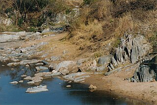
Greenstone belts are zones of variably metamorphosed mafic to ultramafic volcanic sequences with associated sedimentary rocks that occur within Archaean and Proterozoic cratons between granite and gneiss bodies.

The geology of India is diverse. Different regions of the Indian subcontinent contain rocks belonging to different geologic periods, dating as far back as the Eoarchean Era. Some of the rocks are very deformed and altered. Other deposits include recently deposited alluvium that has yet to undergo diagenesis. Mineral deposits of great variety are found in the subcontinent in huge quantities. Even India's fossil record is impressive in which stromatolites, invertebrates, vertebrates and plant fossils are included. India's geographical land area can be classified into the Deccan Traps, Gondwana and Vindhyan.

The Yilgarn Craton is a large craton that constitutes a major part of the Western Australian land mass. It is bounded by a mixture of sedimentary basins and Proterozoic fold and thrust belts. Zircon grains in the Jack Hills, Narryer Terrane have been dated at ~4.27 Ga, with one detrital zircon dated as old as 4.4 Ga.
The geology of Australia includes virtually all known rock types, spanning a geological time period of over 3.8 billion years, including some of the oldest rocks on earth. Australia is a continent situated on the Indo-Australian Plate.
The Gawler Craton covers approximately 440,000 square kilometres of central South Australia. Its Precambrian crystalline basement crustal block was cratonised ca. 1550–1450 Ma. Prior to 1550 Ma the craton comprised a number of active Proterozoic orogenic belts extending back in time to at least 2450 Ma.
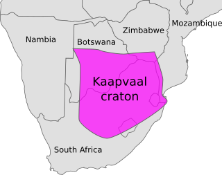
The Kaapvaal Craton, along with the Pilbara Craton of Western Australia, are the only remaining areas of pristine 3.6–2.5 Ga crust on Earth. Similarities of rock records from both these cratons, especially of the overlying late Archean sequences, suggest that they were once part of the Vaalbara supercontinent.
The Cadomian Orogeny was a tectonic event or series of events in the late Neoproterozoic, about 650–550 Ma, which probably included the formation of mountains. This occurred on the margin of the Gondwana continent, involving one or more collisions of island arcs and accretion of other material at a subduction zone. The precise events, and geographical position, are uncertain, but are thought to involve the terranes of Avalonia, Armorica and Iberia. Rocks deformed in the orogeny are found in several areas of Europe, including northern France, the English Midlands, southern Germany, Bohemia, southern Poland and the southwest Iberian Peninsula. The name comes from Cadomus, the Latin name for Caen, northern France. L Bertrand gave the orogeny its name in 1921, naming it after Cadomus the Gaulish name for Caen in Normandy. He defined the end as being marked by Lower Palaeozoic red beds.

The Taltson Magmatic Zone (TMZ) is a north-trending belt of Archean to Paleoproterozoic granitic basement gneiss, amphibolite supracrustal gneissic rock and Paleoproterozoic magmatic rocks in the Canadian Shield, extending from Northern Alberta to the southwestern Northwest Territories. The TMZ basement is 3.2–3.0 Ga and the Rutledge River supracrustal gneisses 2.13–2.09 Ga years old and were intruded by magmatic rocks around 1.99–1.92 Ga.

The geology of Russia, the world's largest country, which extends over much of northern Eurasia, consists of several stable cratons and sedimentary platforms bounded by orogenic (mountain) belts.

The Mozambique Belt is a band in the Earth's crust that extends from East Antarctica through East Africa up to the Arabian-Nubian Shield. It formed as a suture between plates during the Pan-African orogeny, when Gondwana was formed.

The Aravalli Mountain Range is a northeast-southwest trending orogenic belt in the northwest part of India and is part of the Indian Shield that was formed from a series of cratonic collisions. The Aravalli Mountains consist of the Aravalli and Delhi fold belts, and are collectively known as the Aravalli-Delhi orogenic belt. The whole mountain range is about 700 km long. Unlike the much younger Himalayan section nearby, the Aravalli Mountains are believed much older and can be traced back to the Proterozoic Eon. They are arguably the oldest geological feature on Earth. The collision between the Bundelkhand craton and the Marwar craton is believed to be the primary mechanism for the development of the mountain range.
The geology of Central African Republic (CAR) is part of the broader geology of Africa. CAR occupies a swath of ancient rocks, dating back billions of years that record significant aspects of Earth history and yield minerals vital to the country's small economy.
The geology of Western Sahara includes rock units dating back to the Archean more than two billion years old, although deposits of phosphorus formed in the Mesozoic and Cenozoic have helped to prompt the current Moroccan occupation of most of the country.

The geology of the Democratic Republic of the Congo is extremely old, on the order of several billion years for many rocks. The country spans the Congo Craton: a stable section of ancient continental crust, deformed and influenced by several different mountain building orogeny events, sedimentation, volcanism and the geologically recent effects of the East African Rift System in the east. The country's complicated tectonic past have yielded large deposits of gold, diamonds, coltan and other valuable minerals.
The geology of Mauritania is built on more than two billion year old Archean crystalline basement rock in the Reguibat Shield of the West African Craton, a section of ancient and stable continental crust. Mobile belts and the large Taoudeni Basin formed and filled with sediments in the connection with the Pan-African orogeny mountain building event 600 million years ago and a subsequent orogeny created the Mauritanide Belt. In the last 251 million years, Mauritania has accumulated additional sedimentary rocks during periods of marine transgression and sea level retreat. The arid country is 50% covered in sand dunes and has extensive mineral resources, although iron plays the most important role in the economy.

The geology of Sierra Leone is primarily very ancient Precambrian Archean and Proterozoic crystalline igneous and metamorphic basement rock, in many cases more than 2.5 billion years old. Throughout Earth history, Sierra Leone was impacted by major tectonic and climatic events, such as the Leonean, Liberian and Pan-African orogeny mountain building events, the Neoproterozoic Snowball Earth and millions of years of weathering, which has produced thick layers of regolith across much of the country's surface.

The geology of Tanzania began to form in the Precambrian, in the Archean and Proterozoic eons, in some cases more than 2.5 billion years ago. Igneous and metamorphic crystalline basement rock forms the Archean Tanzania Craton, which is surrounded by the Proterozoic Ubendian belt, Mozambique Belt and Karagwe-Ankole Belt. The region experienced downwarping of the crust during the Paleozoic and Mesozoic, as the massive Karoo Supergroup deposited. Within the past 100 million years, Tanzania has experienced marine sedimentary rock deposition along the coast and rift formation inland, which has produced large rift lakes. Tanzania has extensive, but poorly explored and exploited natural resources, including coal, gold, diamonds, graphite and clays.
The geology of Uganda extends back to the Archean and Proterozoic eons of the Precambrian, and much of the country is underlain by gneiss, argillite and other metamorphic rocks that are sometimes over 2.5 billion years old. Sedimentary rocks and new igneous and metamorphic units formed throughout the Proterozoic and the region was partially affected by the Pan-African orogeny and Snowball Earth events. Through the Mesozoic and Cenozoic, ancient basement rock has weathered into water-bearing saprolite and the region has experienced periods of volcanism and rift valley formation. The East Africa Rift gives rise to thick, more geologically recent sediment sequences and the country's numerous lakes. Uganda has extensive natural resources, particularly gold.