List of shields and cratons

Last updated

A craton is an ancient part of the Earth's continental crust which has been more or less stable since Precambrian times. Cratons whose ancient rocks are widely exposed at the surface, often with relatively subdued relief, are known as shields. If the ancient rocks are largely overlain by a cover of younger rocks then the 'hidden' craton may be referred to as a platform.

Contents

List of shields

List of named cratons

Approximate location of Mesoproterozoic (older than 1.3 Ga) cratons in South America and Africa. The Sao Luis and Luis Alves cratonic fragments are shown. Cratons West Gondwana.svg
Approximate location of Mesoproterozoic (older than 1.3 Ga) cratons in South America and Africa. The São Luís and Luís Alves cratonic fragments are shown.
Gondwana and the Kuungan orogen Kuunga2.png
Gondwana and the Kuungan orogen

Listed by modern continent and Gondwana, include:
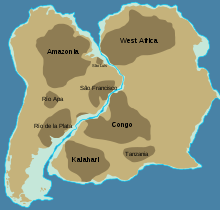
West Gondwana

South America

Africa

Antarctic-East African Orogen

East Gondwana

Indian Subcontinent

Antarctica

Location of Archean and Proterozoic cratons in Australia Australia cratons EN.svg
Location of Archean and Proterozoic cratons in Australia

Australia

North America

North American cratons and basement rocks North america basement rocks.png
North American cratons and basement rocks
North American Craton
.mw-parser-output .legend{page-break-inside:avoid;break-inside:avoid-column}.mw-parser-output .legend-color{display:inline-block;min-width:1.25em;height:1.25em;line-height:1.25;margin:1px 0;text-align:center;border:1px solid black;background-color:transparent;color:black}.mw-parser-output .legend-text{}
North American Craton
Deformed craton
Accretionary belt North america craton nps.gif
North American Craton
  North American Craton
  Deformed craton
  Accretionary belt

Eurasia

Eastern Eurasia

Northern and Eastern Europe

See also

Related Research Articles

<span class="mw-page-title-main">Baltic Shield</span> Ancient segment of Earths crust

The Baltic Shield is a segment of the Earth's crust belonging to the East European Craton, representing a large part of Fennoscandia, northwestern Russia and the northern Baltic Sea. It is composed mostly of Archean and Proterozoic gneisses and greenstone which have undergone numerous deformations through tectonic activity. It contains the oldest rocks of the European continent with a thickness of 250–300 km.

<span class="mw-page-title-main">Craton</span> Old and stable part of the continental lithosphere

A craton is an old and stable part of the continental lithosphere, which consists of Earth's two topmost layers, the crust and the uppermost mantle. Having often survived cycles of merging and rifting of continents, cratons are generally found in the interiors of tectonic plates; the exceptions occur where geologically recent rifting events have separated cratons and created passive margins along their edges. Cratons are characteristically composed of ancient crystalline basement rock, which may be covered by younger sedimentary rock. They have a thick crust and deep lithospheric roots that extend as much as several hundred kilometres into Earth's mantle.

<span class="mw-page-title-main">Subregion</span> Part of a larger geographic region or continent

A subregion is a part of a larger region or continent. Cardinal directions are commonly used to define subregions. There are many criteria for creating systems of subregions; this article is focusing on the UN statistical geoscheme, which is a changing, constantly updated, UN tool based on specific political geography considerations relevant in UN statistics.

<span class="mw-page-title-main">Kenorland</span> Hypothetical Neoarchaean supercontinent from about 2.8 billion years ago

Kenorland was one of the earliest known supercontinents on Earth. It is thought to have formed during the Neoarchaean Era c. 2.72 billion years ago by the accretion of Neoarchaean cratons and the formation of new continental crust. It comprised what later became Laurentia, Baltica, Western Australia and Kalaharia.

<span class="mw-page-title-main">Columbia (supercontinent)</span> Ancient supercontinent of approximately 2,500 to 1,500 million years ago

Columbia, also known as Nuna or Hudsonland, was one of Earth's ancient supercontinents. It was first proposed by John J.W. Rogers and M. Santosh in 2002 and is thought to have existed approximately 2,500 to 1,500 million years ago, in the Paleoproterozoic Era. The assembly of the supercontinent was likely completed during global-scale collisional events from 2100 to 1800 million years ago.

<span class="mw-page-title-main">Shield (geology)</span> Large stable area of exposed Precambrian crystalline rock

A shield is a large area of exposed Precambrian crystalline igneous and high-grade metamorphic rocks that form tectonically stable areas. These rocks are older than 570 million years and sometimes date back to around 2 to 3.5 billion years. They have been little affected by tectonic events following the end of the Precambrian, and are relatively flat regions where mountain building, faulting, and other tectonic processes are minor, compared with the activity at their margins and between tectonic plates. Shields occur on all continents.

<span class="mw-page-title-main">Greenstone belt</span> Zone of variably metamorphosed rocks occurring in Archaean and Proterozoic cratons

Greenstone belts are zones of variably metamorphosed mafic to ultramafic volcanic sequences with associated sedimentary rocks that occur within Archaean and Proterozoic cratons between granite and gneiss bodies.

The Central Lapland Greenstone Belt (CLGB) is a greenstone belt located in the northern part of the Fennoscandian Shield. The region belongs to Lapland, northern Finland. The CLGB is part of a much larger belt of Paleoproterozoic greenstones, a cover of metamorphosed volcanic and sedimentary rocks that cover the Archean basement, the latter which is representative of the Archaean Karelian craton. Deposition of the cover sequence occurred between about 2.5 Ga and 1.8 Ga, thus it preserves information about Earth's history from a period that encompass about 700 Ma.

<span class="mw-page-title-main">Somali Plate</span> Minor tectonic plate including the east coast of Africa and the adjoining seabed

The Somali Plate is a minor tectonic plate which straddles the Equator in the Eastern Hemisphere. It is currently in the process of separating from the African Plate along the East African Rift Valley. It is approximately centered on the island of Madagascar and includes about half of the east coast of Africa, from the Gulf of Aden in the north through the East African Rift Valley. The southern boundary with the Nubian-African Plate is a diffuse plate boundary consisting of the Lwandle Plate.

The Pan-African orogeny was a series of major Neoproterozoic orogenic events which related to the formation of the supercontinents Gondwana and Pannotia about 600 million years ago. This orogeny is also known as the Pan-Gondwanan or Saldanian Orogeny. The Pan-African orogeny and the Grenville orogeny are the largest known systems of orogenies on Earth. The sum of the continental crust formed in the Pan-African orogeny and the Grenville orogeny makes the Neoproterozoic the period of Earth's history that has produced most continental crust.

The East European Craton (EEC) is the core of the Baltica proto-plate and consists of three crustal regions/segments: Fennoscandia to the northwest, Volgo-Uralia to the east, and Sarmatia to the south. Fennoscandia includes the Baltic Shield and has a diversified accretionary Archaean and early Proterozoic crust, while Sarmatia has an older Archaean crust. The Volgo-Uralia region has a thick sedimentary cover, however deep drillings have revealed mostly Archaean crust. There are two shields in the East European Craton: the Baltic/Fennoscandian shield and the Ukrainian shield. The Ukrainian Shield and the Voronezh Massif consists of 3.2-3.8 Ga Archaean crust in the southwest and east, and 2.3-2.1 Ga Early Proterozoic orogenic belts.

<span class="mw-page-title-main">Churchill Craton</span> Northwest section of the Canadian Shield from southern Saskatchewan and Alberta to northern Nunavut

The Churchill Craton is the northwest section of the Canadian Shield and stretches from southern Saskatchewan and Alberta to northern Nunavut. It has a very complex geological history punctuated by at least seven distinct regional tectonometamorphic intervals, including many discrete accretionary magmatic events. The Western Churchill province is the part of the Churchill Craton that is exposed north and west of the Hudson Bay. The Archean Western Churchill province contributes to the complicated and protracted tectonic history of the craton and marks a major change in the behaviour of the Churchill Craton with many remnants of Archean supracrustal and granitoid rocks.

<span class="mw-page-title-main">Amazonian Craton</span> Geologic province in South America

The Amazonian Craton is a geologic province located in South America. It occupies a large portion of the central, north and eastern part of the continent and represents one of Earth's largest cratonic regions. The Guiana Shield and Central Brazil Shield constitute respectively the northern and southern exhumed parts of the craton. Between the two shields lies the Amazon Rift, a zone of weakness within the craton. Smaller cratons of Precambrian rocks south of the Amazonian Shield are the Río de la Plata Craton and the São Francisco Craton, which lies to the east.

<span class="mw-page-title-main">Ur (continent)</span> Hypothetical archaean supercontinent from about 3.1 billion years ago

Ur is a hypothetical supercontinent that formed in the Archean era around 3.1 billion years ago.

<span class="mw-page-title-main">Laurentia</span> A large continental craton that forms the ancient geological core of the North American continent

Laurentia or the North American Craton is a large continental craton that forms the ancient geological core of North America. Many times in its past, Laurentia has been a separate continent, as it is now in the form of North America, although originally it also included the cratonic areas of Greenland and also the northwestern part of Scotland, known as the Hebridean Terrane. During other times in its past, Laurentia has been part of larger continents and supercontinents and itself consists of many smaller terranes assembled on a network of Early Proterozoic orogenic belts. Small microcontinents and oceanic islands collided with and sutured onto the ever-growing Laurentia, and together formed the stable Precambrian craton seen today.

<span class="mw-page-title-main">East Antarctic Shield</span> Cratonic rock body which makes up most of the continent Antarctica

The East Antarctic Shield or Craton is a cratonic rock body that covers 10.2 million square kilometers or roughly 73% of the continent of Antarctica. The shield is almost entirely buried by the East Antarctic Ice Sheet that has an average thickness of 2200 meters but reaches up to 4700 meters in some locations. East Antarctica is separated from West Antarctica by the 100–300 kilometer wide Transantarctic Mountains, which span nearly 3,500 kilometers from the Weddell Sea to the Ross Sea. The East Antarctic Shield is then divided into an extensive central craton that occupies most of the continental interior and various other marginal cratons that are exposed along the coast.

<span class="mw-page-title-main">Svecofennian orogeny</span> Geological process that resulted in formation of continental crust in Sweden, Finland and Russia

The Svecofennian orogeny is a series of related orogenies that resulted in the formation of much of the continental crust in what is today Sweden and Finland plus some minor parts of Russia. The orogenies lasted from about 2000 to 1800 million years ago during the Paleoproterozoic Era. The resulting orogen is known as the Svecofennian orogen or Svecofennides. To the west and southwest the Svecofennian orogen limits with the generally younger Transscandinavian Igneous Belt. It is assumed that the westernmost fringes of the Svecofennian orogen have been reworked by the Sveconorwegian orogeny just as the western parts of the Transscandinavian Igneous Belt has. The Svecofennian orogeny involved the accretion of numerous island arcs in such manner that the pre-existing craton grew with this new material from what is today northeast to the southwest. The accretion of the island arcs was also related to two other processes that occurred in the same period; the formation of magma that then cooled to form igneous rocks and the metamorphism of rocks.

<span class="mw-page-title-main">Geology of Finland</span> Overview of the geology of Finland

The geology of Finland is made up of a mix of geologically very young and very old materials. Common rock types are orthogneiss, granite, metavolcanics and metasedimentary rocks. On top of these lies a widespread thin layer of unconsolidated deposits formed in connection to the Quaternary ice ages, for example eskers, till and marine clay. The topographic relief is rather subdued because mountain massifs were worn down to a peneplain long ago.

The Blekinge-Bornholm Province is an area of the Fennoscandian Shield spanning the Swedish province of Blekinge and the nearby island of Bornholm in the Baltic Sea.

References