Related Research Articles

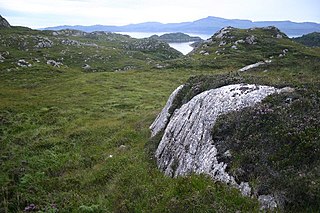
The Canadian Shield, also called the Laurentian Shield or the Laurentian Plateau, is a geologic shield, a large area of exposed Precambrian igneous and high-grade metamorphic rocks. It forms the North American Craton, the ancient geologic core of the North American continent. Glaciation has left the area with only a thin layer of soil, through which exposures of igneous bedrock resulting from its long volcanic history are frequently visible. As a deep, common, joined bedrock region in eastern and central Canada, the shield stretches north from the Great Lakes to the Arctic Ocean, covering over half of Canada and most of Greenland; it also extends south into the northern reaches of the continental United States.

A craton is an old and stable part of the continental lithosphere, which consists of Earth's two topmost layers, the crust and the uppermost mantle. Having often survived cycles of merging and rifting of continents, cratons are generally found in the interiors of tectonic plates; the exceptions occur where geologically recent rifting events have separated cratons and created passive margins along their edges. Cratons are characteristically composed of ancient crystalline basement rock, which may be covered by younger sedimentary rock. They have a thick crust and deep lithospheric roots that extend as much as several hundred kilometres into Earth's mantle.

A shield is a large area of exposed Precambrian crystalline igneous and high-grade metamorphic rocks that form tectonically stable areas. These rocks are older than 570 million years and sometimes date back to around 2 to 3.5 billion years. They have been little affected by tectonic events following the end of the Precambrian, and are relatively flat regions where mountain building, faulting, and other tectonic processes are minor, compared with the activity at their margins and between tectonic plates. Shields occur on all continents.

The Arabian-Nubian Shield (ANS) is an exposure of Precambrian crystalline rocks on the flanks of the Red Sea. The crystalline rocks are mostly Neoproterozoic in age. Geographically – and from north to south – the ANS includes parts of Israel, Jordan, Egypt, Saudi Arabia, Sudan, Eritrea, Ethiopia, Yemen, and Somalia. The ANS in the north is exposed as part of the Sahara Desert and Arabian Desert, and in the south in the Ethiopian Highlands, Asir province of Arabia and Yemen Highlands.
The Pan-African orogeny was a series of major Neoproterozoic orogenic events which related to the formation of the supercontinents Gondwana and Pannotia about 600 million years ago. This orogeny is also known as the Pan-Gondwanan or Saldanian Orogeny. The Pan-African orogeny and the Grenville orogeny are the largest known systems of orogenies on Earth. The sum of the continental crust formed in the Pan-African orogeny and the Grenville orogeny makes the Neoproterozoic the period of Earth's history that has produced most continental crust.
In geology, basement and crystalline basement are crystalline rocks lying above the mantle and beneath all other rocks and sediments. They are sometimes exposed at the surface, but often they are buried under miles of rock and sediment. The basement rocks lie below a sedimentary platform or cover, or more generally any rock below sedimentary rocks or sedimentary basins that are metamorphic or igneous in origin. In the same way, the sediments or sedimentary rocks on top of the basement can be called a "cover" or "sedimentary cover".
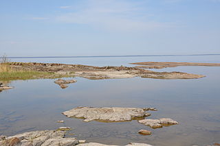
The East European Craton (EEC) is the core of the Baltica proto-plate and consists of three crustal regions/segments: Fennoscandia to the northwest, Volgo-Uralia to the east, and Sarmatia to the south. Fennoscandia includes the Baltic Shield and has a diversified accretionary Archaean and early Proterozoic crust, while Sarmatia has an older Archaean crust. The Volgo-Uralia region has a thick sedimentary cover, however deep drillings have revealed mostly Archaean crust. There are two shields in the East European Craton: the Baltic/Fennoscandian shield and the Ukrainian shield. The Ukrainian Shield and the Voronezh Massif consists of 3.2-3.8 Ga Archaean crust in the southwest and east, and 2.3-2.1 Ga Early Proterozoic orogenic belts.

The Australian Shield is a geological feature known as a shield that occupies more than half of the continent of Australia. The word shield is used because it refers to ancient, molten rock which has cooled and solidified.
In geology, a platform is a continental area covered by relatively flat or gently tilted, mainly sedimentary strata, which overlie a basement of consolidated igneous or metamorphic rocks of an earlier deformation. Platforms, shields and the basement rocks together constitute cratons. Platform sediments can be classified into the following groups: a "protoplatform" of metamorphosed sediments at the bottom, a "quasiplatform" of slightly deformed sediments, a "cataplatform", and an "orthoplatform" at the top. The Mesoproterozoic Jotnian sediments of the Baltic area are examples of a "quasiplatform". The post-Ordovician rocks of the South American Platform are examples of an orthoplatform.
Maitland Volcano is a heavily eroded shield volcano in the Northern Interior of British Columbia, Canada. It is 83 km (52 mi) southeast of the small community of Telegraph Creek in what is now the Klappan Range of the northern Skeena Mountains. This multi-vent volcano covered a remarkably large area and was topped by a younger volcanic edifice. Little remains of Maitland Volcano today, limited only to eroded lava flows and distinctive upstanding landforms created when magma hardened within the vents of the volcano.

The Florida Platform is a flat geological feature with the emergent portion forming the Florida peninsula.

The geology of Russia, the world's largest country, which extends over much of northern Eurasia, consists of several stable cratons and sedimentary platforms bounded by orogenic (mountain) belts.

The geology of North America is a subject of regional geology and covers the North American continent, the third-largest in the world. Geologic units and processes are investigated on a large scale to reach a synthesized picture of the geological development of the continent.

The East Antarctic Shield or Craton is a cratonic rock body that covers 10.2 million square kilometers or roughly 73% of the continent of Antarctica. The shield is almost entirely buried by the East Antarctic Ice Sheet that has an average thickness of 2200 meters but reaches up to 4700 meters in some locations. East Antarctica is separated from West Antarctica by the 100–300 kilometer wide Transantarctic Mountains, which span nearly 3,500 kilometers from the Weddell Sea to the Ross Sea. The East Antarctic Shield is then divided into an extensive central craton that occupies most of the continental interior and various other marginal cratons that are exposed along the coast.
The sub-Cambrian peneplain is an ancient, extremely flat, erosion surface (peneplain) that has been exhumed and exposed by erosion from under Cambrian strata over large swathes of Fennoscandia. Eastward, where this peneplain dips below Cambrian and other Lower Paleozoic cover rocks. The exposed parts of this peneplain are extraordinarily flat with relief of less than 20 m. The overlying cover rocks demonstrate that the peneplain was flooded by shallow seas during the Early Paleozoic. Being the oldest identifiable peneplain in its area the Sub-Cambrian peneplain qualifies as a primary peneplain.

The geology of Germany is heavily influenced by several phases of orogeny in the Paleozoic and the Cenozoic, by sedimentation in shelf seas and epicontinental seas and on plains in the Permian and Mesozoic as well as by the Quaternary glaciations.
The geology of Sicily records the collision of the Eurasian and the African plates during westward-dipping subduction of the African slab since late Oligocene. Major tectonic units are the Hyblean foreland, the Gela foredeep, the Apenninic-Maghrebian orogen, and the Calabrian Arc. The orogen represents a fold-thrust belt that folds Mesozoic carbonates, while a major volcanic unit is found in an eastern portion of the island. The collision of Africa and Eurasia is a retreating subduction system, such that the descending Africa is falling away from Eurasia, and Eurasia extends and fills the space as the African plate falls into the mantle, resulting in volcanic activity in Sicily and the formation of Tyrrhenian slab to the north.

The geology of Ethiopia includes rocks of the Neoproterozoic East African Orogeny, Jurassic marine sediments and Quaternary rift-related volcanism. Events that greatly shaped Ethiopian geology is the assembly and break-up of Gondwana and the present-day rifting of Africa.
The geology of Ukraine is the regional study of rocks, minerals, tectonics, natural resources and groundwater in Ukraine. The oldest rocks in the region are part of the Ukrainian Shield and formed more than 2.5 billion years ago in the Archean eon of the Precambrian. Extensive tectonic evolution and numerous orogeny mountain-building events fractured the crust into numerous block, horsts, grabens and depressions. Ukraine was intermittently flooded as the crust downwarped during much of the Paleozoic, Mesozoic and early Cenozoic, before the formation of the Alps and Carpathian Mountains defined much of its current topography and tectonics. Ukraine was impacted by the Pleistocene glaciations within the last several hundred thousand years. The country has numerous metal deposits as well as minerals, building stone and high-quality industrial sands.
References
- ↑ Ayalew, Teklewold; Bell, Keith; Moore, John M.; Parrish, Randall R. (1990). "U-Pb and Rb-Sr geochronology of the Western Ethiopian Shield". Geological Society of America Bulletin. 102 (9): 1309. Bibcode:1990GSAB..102.1309A. doi:10.1130/0016-7606(1990)102<1309:UPARSG>2.3.CO;2.
| | This plate tectonics article is a stub. You can help Wikipedia by expanding it. |