Related Research Articles

Laurasia was the more northern of two large landmasses that formed part of the Pangaea supercontinent from around 335 to 175 million years ago (Mya), the other being Gondwana. It separated from Gondwana 215 to 175 Mya during the breakup of Pangaea, drifting farther north after the split and finally broke apart with the opening of the North Atlantic Ocean c. 56 Mya. The name is a portmanteau of Laurentia and Asia.
Kenorland was one of the earliest known supercontinents on Earth. It is thought to have formed during the Neoarchaean Era c. 2.72 billion years ago by the accretion of Neoarchaean cratons and the formation of new continental crust. It comprised what later became Laurentia, Baltica, Western Australia and Kalaharia.

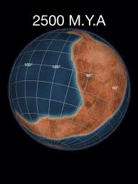
Arctica, or Arctida was an ancient continent which formed approximately 2.565 billion years ago in the Neoarchean era. It was made of Archaean cratons, including the Siberian Craton, with its Anabar/Aldan shields in Siberia, and the Slave, Wyoming, Superior, and North Atlantic cratons in North America. Arctica was named by Rogers 1996 because the Arctic Ocean formed by the separation of the North American and Siberian cratons. Russian geologists writing in English call the continent "Arctida" since it was given that name in 1987, alternatively the Hyperborean craton, in reference to the hyperboreans in Greek mythology.

Baltica is a paleocontinent that formed in the Paleoproterozoic and now constitutes northwestern Eurasia, or Europe north of the Trans-European Suture Zone and west of the Ural Mountains. The thick core of Baltica, the East European Craton, is more than three billion years old and formed part of the Rodinia supercontinent at c. 1 Ga.

The Congo Craton, covered by the Palaeozoic-to-recent Congo Basin, is an ancient Precambrian craton that with four others makes up the modern continent of Africa. These cratons were formed between about 3.6 and 2.0 billion years ago and have been tectonically stable since that time. All of these cratons are bounded by younger fold belts formed between 2.0 billion and 300 million years ago.

The Yilgarn Craton is a large craton that constitutes the bulk of the Western Australian land mass. It is bounded by a mixture of sedimentary basins and Proterozoic fold and thrust belts. Zircon grains in the Jack Hills, Narryer Terrane have been dated at ~4.27 Ga, with one detrital zircon dated as old as 4.4 Ga.
The Amazonian Craton is a geologic province located in South America. It occupies a large portion of the central, north and eastern part of the continent and represents one of Earth's largest cratonic regions. The Guiana Shield and Central Brazil Shield constitute respectively the northern and southern exhumed parts of the craton. Between the two shields lies the Amazon Rift, a zone of weakness within the craton. Smaller cratons of Precambrian rocks south of the Amazonian Shield are the Río de la Plata Craton and the São Francisco Craton, which lies to the east.

The geology of the Rocky Mountains is that of a discontinuous series of mountain ranges with distinct geological origins. Collectively these make up the Rocky Mountains, a mountain system that stretches from Northern British Columbia through central New Mexico and which is part of the great mountain system known as the North American Cordillera.

The North China Craton is a continental crustal block with one of Earth's most complete and complex records of igneous, sedimentary and metamorphic processes. It is located in northeast China, Inner Mongolia, the Yellow Sea, and North Korea. The term craton designates this as a piece of continent that is stable, buoyant and rigid. Basic properties of the cratonic crust include being thick, relatively cold when compared to other regions, and low density. The North China Craton is an ancient craton, which experienced a long period of stability and fitted the definition of a craton well. However, the North China Craton later experienced destruction of some of its deeper parts (decratonization), which means that this piece of continent is no longer as stable.
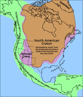
Laurentia or the North American Craton is a large continental craton that forms the ancient geological core of North America. Many times in its past, Laurentia has been a separate continent, as it is now in the form of North America, although originally it also included the cratonic areas of Greenland and also the northwestern part of Scotland, known as the Hebridean Terrane. During other times in its past, Laurentia has been part of larger continents and supercontinents and itself consists of many smaller terranes assembled on a network of Early Proterozoic orogenic belts. Small microcontinents and oceanic islands collided with and sutured onto the ever-growing Laurentia, and together formed the stable Precambrian craton seen today.

The Circum-Superior Belt is a widespread Paleoproterozoic large igneous province in the Canadian Shield of Northern, Western and Eastern Canada. It extends more than 3,400 km (2,100 mi) from northeastern Manitoba through northwestern Ontario, southern Nunavut to northern Quebec and into western Labrador. Igneous rocks of the Circum-Superior Belt are mafic-ultramafic in composition, deposited in the Labrador Trough near Ungava Bay, the Cape Smith Belt near the southern shore of Hudson Strait and along the eastern shore of Hudson Bay in its northern portion; the Thompson and Fox River belts in the northwest and the Marquette Range Supergroup in its southern portion. The Circum Superior Belt also hosts a rare example of Proterozoic Komatiite, in the Winnipegosis komatiite belt.

The geology of North America is a subject of regional geology and covers the North American continent, the third-largest in the world. Geologic units and processes are investigated on a large scale to reach a synthesized picture of the geological development of the continent.
The Yenisey Fold Belt is a fold belt in Russia that divides the Siberian craton from the West Siberian basin, extending about 700 kilometres (430 mi), with NW-SE strike. This belt is divided into northern and southern regions by the Angara fault which has left slip. Much of the rock was formed by Neoproterozoic accretion.
The Buffalo Head Terrane (BHT) is a terrane in the western Canadian Shield in northern Alberta. It is covered by 1,600 m (5,200 ft) of Devonian and Cretaceous sediments and its centre is intruded by the 88–86 Ma kimberlites of the diamondiferous Buffalo Head Hills kimberlite province.
The geology of Nunavut began to form nearly three billion years ago in the Archean and the territory preserves some of the world's oldest rock units.
The geology of Brazil includes very ancient craton basement rock from the Precambrian overlain by sedimentary rocks and intruded by igneous activity, as well as impacted by the rifting of the Atlantic Ocean.
The Superior Craton is a stable crustal block covering Quebec, Ontario, and southeast Manitoba in Canada, and northern Minnesota in the United States. It is the biggest craton among those formed during the Archean period. A craton is a large part of the Earth's crust that has been stable and subjected to very little geological changes over a long time. The size of Superior Craton is about 1,572,000 km2. The craton underwent a series of events from 4.3 to 2.57 Ga. These events included the growth, drifting and deformation of both oceanic and continental crusts.
The Laxfordian orogeny was an orogenic event between 1.9 and 1 billion years ago. It primarily affected the North Atlantic Craton, in particular a section that cleaved off during the Mesozoic as the Scottish Shield Fragment, part of the Lewisian complex within the Hebridean Terrane.
The Akia terrane is a tectonostratigraphic terrane located in the North Atlantic Craton in southern West Greenland. The Akia terrane is bounded to the Southeast by the Eo- to Neo-archaean tectonostratigraphic terranes of the Nuuk region, and to the North by the recently recognised Alanngua Complex, which separates the Akia terrane from the Neoarchaean Tuno terrane. The crust in the Akia terrane formed in two major pulses. The first at ~3.2 Ga, predominantly comprises dioritic gneisses, whereas the second, at ~3.0 Ga comprises a more diverse mix of TTG and dioritic gneisses with enclaves of supracrustal rocks and mafic-ultramafic intrusions. Supracrustal rocks are largely tholeiitic and calc-alkaline amphibolites formed at ~3.07 Ga. The mafic-ultramafic intrusions include peridotite cumulates and a belt of noritic intrusions formed at the same time as the TTG gneisses, the Maniitsoq Norite Belt. Various tectonic settings have been proposed for the 3.0 Ga crust forming event, including subduction related magmatism, stagnant lid tectonic processes, and crust and mantle melting in an ultra-hot orogeny.
References
Notes
- ↑ Wittig et al. 2010 , Crustal evolution of the Greenlandic North Atlantic Craton, p. 168
- ↑ Buchan et al. 2000 , Geological setting, pp. 168–170
- ↑ Tappe et al. 2006 , Introduction, p. 1262
- ↑ Tappe, Steenfelt & Nielsen 2012 , Timing and possible tectonic settings, p. 115
- ↑ Kolb, Dziggel & Schlatter 2013 , Regional geology/Table 1, pp. 32–33
Sources
- Buchan, K. L.; Mertanen, S.; Park, R. G.; Pesonen, L. J.; Elming, S. Å.; Abrahamsen, N.; Bylund, G. (2000). "Comparing the drift of Laurentia and Baltica in the Proterozoic: the importance of key palaeomagnetic poles" (PDF). Tectonophysics. 319 (3): 167–198. doi:10.1016/S0040-1951(00)00032-9 . Retrieved 24 June 2018.
- Kolb, J.; Dziggel, A.; Schlatter, D. M. (2013). "Gold occurrences of the Archean North Atlantic craton, southwestern Greenland: A comprehensive genetic model". Ore Geology Reviews. 54: 29–58. doi:10.1016/j.oregeorev.2013.01.019.
- Tappe, S.; Foley, S. F.; Jenner, G. A.; Heaman, L. M.; Kjarsgaard, B. A.; Romer, R. L.; Stracke, A.; Joyce, N.; Hoefs, J. (2006). "Genesis of ultramafic lamprophyres and carbonatites at Aillik Bay, Labrador: a consequence of incipient lithospheric thinning beneath the North Atlantic craton" (PDF). Journal of Petrology. 47 (7): 1261–1315. doi:10.1093/petrology/egl008 . Retrieved 23 June 2018.
- Tappe, S.; Steenfelt, A.; Nielsen, T. (2012). "Asthenospheric source of Neoproterozoic and Mesozoic kimberlites from the North Atlantic craton, West Greenland: new high-precision U–Pb and Sr–Nd isotope data on perovskite". Chemical Geology. 320: 113–127. doi:10.1016/j.chemgeo.2012.05.026 . Retrieved 23 June 2018.
- Wittig, N.; Webb, M.; Pearson, D. G.; Dale, C. W.; Ottley, C. J.; Hutchison, M.; Jensen, S. M.; Luguet, A. (2010). "Formation of the North Atlantic Craton: Timing and mechanisms constrained from Re–Os isotope and PGE data of peridotite xenoliths from SW Greenland" (PDF). Chemical Geology. 276 (3): 166–187. doi:10.1016/j.chemgeo.2010.06.002 . Retrieved 23 June 2018.
| | This geology article is a stub. You can help Wikipedia by expanding it. |