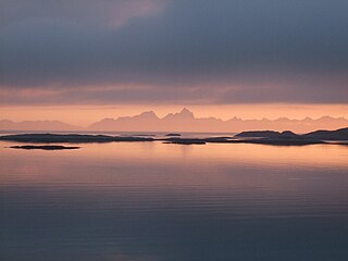
The Norwegian Sea is a marginal sea, grouped with either the Atlantic Ocean or the Arctic Ocean, northwest of Norway between the North Sea and the Greenland Sea, adjoining the Barents Sea to the northeast. In the southwest, it is separated from the Atlantic Ocean by a submarine ridge running between Iceland and the Faroe Islands. To the north, the Jan Mayen Ridge separates it from the Greenland Sea.
The Bay of Biscay, known in Spain as the Gulf of Biscay, and in France and some border regions as the Gulf of Gascony, is a gulf of the northeast Atlantic Ocean located south of the Celtic Sea. It lies along the western coast of France from Point Penmarc'h to the Spanish border, and the northern coast of Spain west to Cape Ortegal. The south area of the Bay of Biscay that washes over the northern coast of Spain is known locally as the Cantabrian Sea.
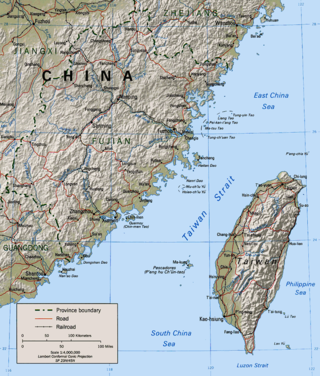
The Taiwan Strait is a 180-kilometer -wide strait separating the island of Taiwan and continental Asia. The strait is part of the South China Sea and connects to the East China Sea to the north. The narrowest part is 130 km wide.

The Mull of Kintyre is the southwesternmost tip of the Kintyre Peninsula in southwest Scotland. From here, the Antrim coast of Northern Ireland is visible on a calm and clear day, and a historic lighthouse, the second commissioned in Scotland, guides shipping in the intervening North Channel. The area has been immortalised in popular culture by the 1977 hit song "Mull of Kintyre" by Kintyre resident Paul McCartney's band of the time, Wings.

The Celebes Sea, or Sulawesi Sea, of the western Pacific Ocean is bordered on the north by the Sulu Archipelago and Sulu Sea and Mindanao Island of the Philippines, on the east by the Sangihe Islands chain, on the south by Sulawesi's Minahasa Peninsula, and on the west by northern Kalimantan in Indonesia. It extends 420 miles (675 km) north-south by 520 mi (840 km) east-west and has a total surface area of 110,000 square miles (280,000 km2), to a maximum depth of 20,300 feet (6,200 m). South of the Cape Mangkalihat, the sea opens southwest through the Makassar Strait into the Java Sea.

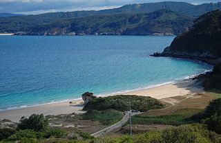
The Celtic Sea is the area of the Atlantic Ocean off the southern coast of Ireland bounded to the east by Saint George's Channel; other limits include the Bristol Channel, the English Channel, and the Bay of Biscay, as well as adjacent portions of Wales, Cornwall, and Brittany. The southern and western boundaries are delimited by the continental shelf, which drops away sharply. The Isles of Scilly are an archipelago of small islands in the sea.
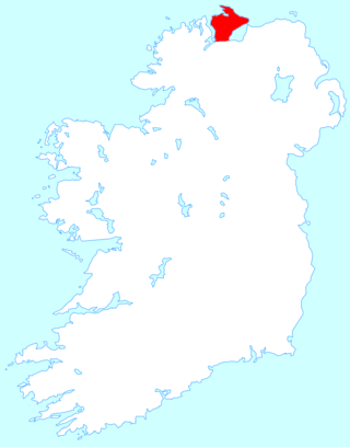
Inishowen is a peninsula in the north of County Donegal in Ireland. Inishowen is the largest peninsula on the island of Ireland.

The Arafura Sea lies west of the Pacific Ocean, overlying the continental shelf between Australia and Western New Guinea, which is the Indonesian part of the Island of New Guinea.

Lincoln Sea is a body of water in the Arctic Ocean, stretching from Cape Columbia, Canada, in the west to Cape Morris Jesup, Greenland, in the east. The northern limit is defined as the great circle line between those two headlands. It is covered with sea ice throughout the year, the thickest sea ice in the Arctic Ocean, which can be up to 15 m (49 ft) thick. Water depths range from 100 m (330 ft) to 300 m (980 ft). Water and ice from Lincoln Sea empty into Robeson Channel, the northernmost part of Nares Strait, most of the time.

The Convention for the Protection of the Marine Environment of the North-East Atlantic or OSPAR Convention is the current legislative instrument regulating international cooperation on environmental protection in the North-East Atlantic. Work carried out under the convention is managed by the OSPAR Commission, which is made up of representatives of the Governments of the 15 signatory nations, and representatives of the European Commission, representing the European Union.
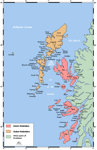
The Sea of the Hebrides is a small, partly sheltered section of the North Atlantic Ocean, indirectly off the southern part of the north-west coast of Scotland. To the east are the mainland of Scotland and the northern Inner Hebrides ; to the west are the southern Outer Hebrides islands, principally South Uist, Eriskay, and Barra. To the north is the Little Minch, a channel connecting it with the Minch.

The Irish Sea is an extensive body of water that separates the islands of Ireland and Great Britain. It is linked to the Celtic Sea in the south by St George's Channel and to the Inner Seas off the West Coast of Scotland in the north by the North Channel. Anglesey, North Wales, is the largest island in the Irish Sea, followed by the Isle of Man. The term Manx Sea may occasionally be encountered.

The Iberian Plate with the microcontinent Iberia encompassed not only the Iberian Peninsula but also Corsica, Sardinia, the Balearic Islands, and the Briançonnais zone of the Penninic nappes of the Alps. The Iberian plate is a part of the Eurasian plate.

The Inner Seas off the West Coast of Scotland is a marine area designated by the International Hydrographic Organization (IHO). It consists of a number of waterbodies between the Scottish mainland, the Outer Hebrides islands, and the coast of Ireland.

It is a central tenet of the EU maritime policy that all seas have a particular nature, defined by their geography, their ecology, their economies and their people. Most seas are nested and do not, except for specific purposes such as hydrography or fisheries management, have sharp, recognised boundaries. One important sea for purposes of fisheries management is referred to as the "seas West of Scotland". In line with the EU maritime policy, the sea does not only encompass the waters but also the people and economy of the areas bordering that sea.

The borders of the oceans are the limits of Earth's oceanic waters. The definition and number of oceans can vary depending on the adopted criteria. The principal divisions of the five oceans are the Pacific Ocean, Atlantic Ocean, Indian Ocean, Southern (Antarctic) Ocean, and Arctic Ocean. Smaller regions of the oceans are called seas, gulfs, bays, straits, and other terms. Geologically, an ocean is an area of oceanic crust covered by water.
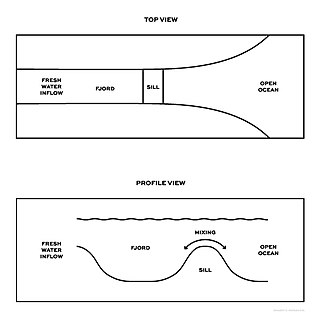
An aquatic sill is a sea floor barrier of relatively shallow depth that restricts water movement between benthic zones of an oceanic basin or lake bottom. There are roughly 400 sills in the Earth's oceans, covering 0.01% of the seafloor. A classic example is the Strait of Gibraltar Gateway between the Mediterranean sea and the Atlantic Ocean.

The marine ecoregions of the South African exclusive economic zone are a set of geographically delineated regions of similar ecological characteristics on a fairly broad scale, covering the exclusive economic zone along the South African coast.
Hebrides Terrace Seamount is a seamount in the Atlantic Ocean, west-southwest from the Hebrides, Scotland. It formed through volcanism during the early Cenozoic in the Rockall Trough 60 million to 67 million years ago and afterwards sank below sea level. Presently, it is a flat-topped underwater mountain that rises to about 980 metres depth. "Coral gardens" that host a number of animals are found on its slopes.
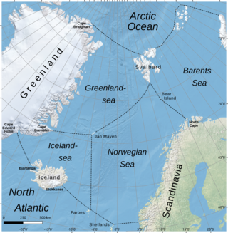
The Iceland Sea is a small body of water delimited by the Jan Mayen fracture zone to the north, Greenland to the west, the Denmark Strait to the south, and the Jan Mayen Ridge to the east. Depths usually range from 500 to 2,000 meters but can be shallower on the Continental shelf of East Greenland. The Kolbeinsey Ridge crosses the Iceland Sea, dividing it into eastern and western parts.
