 |
|---|
Chirundu is a constituency of the National Assembly of Zambia, [1] created in 2016. [2] It covers the towns of Chirundu and Lusitu in Chirundu District of Southern Province.
| |
|---|
Chirundu is a constituency of the National Assembly of Zambia, [1] created in 2016. [2] It covers the towns of Chirundu and Lusitu in Chirundu District of Southern Province.
| Election year | MP | Party |
|---|---|---|
| 2016 | Douglas Syakalima | United Party for National Development |
| 2021 | Douglas Syakalima | United Party for National Development |

The Chinhoyi Caves are a group of limestone and dolomite caves in north central Zimbabwe. Designated a National Park in 1955, and managed by the Zimbabwe Parks & Wildlife Management Authority.
Chirundu may refer to:
Chirundu is a village and border post in Zimbabwe on the border with Zambia, in Mashonaland West province. The name Chirundu means "Big Hill". The village is located on the banks of the Zambezi river, and as a result it lies in the hot Zambezi Valley. It is the site of the Chirundu Bridges, two road bridges across the Zambezi river.
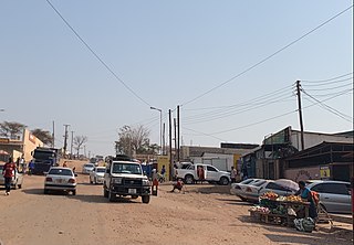
Chirundu, Zambia is a town in the Southern Province of Zambia at the border with Zimbabwe. It is the site of two road bridges across the Zambezi river, the Chirundu Bridges.

The ten provinces of Zambia are divided into a total of 116 districts as of 2018.

The Chirundu Bridge now consists of two road bridges side by side across the Zambezi River between the small town of Chirundu, Zambia and the village of Chirundu, Zimbabwe. At this location around 65 km downstream from the Kariba Dam the river is about 400 m wide. The bridges were once seen as part of a Cape to Cairo Road and thus are on the Harare to Lusaka section of the route.
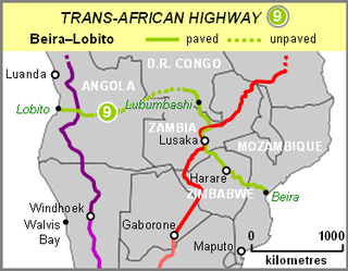
The Beira–Lobito Highway or TAH 9 is Trans-African Highway 9 in the transcontinental road network being developed by the United Nations Economic Commission for Africa (UNECA), the African Development Bank (ADB), and the African Union. The route has a length of 3,523 km (2,189 mi) crossing Angola, the most southerly part of the Democratic Republic of the Congo, Zambia, Zimbabwe, and central Mozambique.
Itezhi-Tezhi is a small town in the Southern Province of Zambia. It is the seat of the Itezhi-Tezhi District. It lies west of the town of Namwala on the border of the Kafue National Park.

The A4 is a highway, also known as the R1 Highway, which runs between Beitbridge and Harare. From Beitbridge it passes through Rutenga, Ngundu, Masvingo, Mvuma, Chivhu before reaching Harare.

Chama District with the headquarters at Chama is the largest district of the Eastern Province in Zambia and includes a large wilderness in the Upper Luangwa valley just north-east of the North Luangwa National Park. It is made up of two constituencies, namely Chama North and Chama South.

Itezhi-Tezhi District is a district of Zambia, located in Southern Province. The capital lies at Itezhi-Tezhi. As of the 2000 Zambian Census, the district had a population of 43111 people.

Visitors to Zimbabwe must obtain a visa from one of the Zimbabwean diplomatic missions or online, unless they come from one of the visa exempt countries or are eligible for visa on arrival. As of November 2014 Zimbabwe and Zambia also offer a universal tourist visa.
The R3 highway is a primary road in Zimbabwe that runs from the capital city, Harare, to the Chirundu Border Post with Zambia. It is also known as the A1 highway. It is part of both the Beira–Lobito Highway and the Cape to Cairo Road.

Chirundu–Beitbridge Road Corridor is a Trans-African Highway Network Zimbabwean link between South Africa and Zambia. It is part of the North–South Corridor Project and forms the entire Zimbabwean section of the Cape to Cairo Road.
The M15 Makuti-Kariba Highway is a 2-way asphalt surface international highway from the A1 Highway at Makuti to Zambia via the Kariba Dam Wall. The maximum speed on this road is 120 kilometres (75 mi) per hour.

The T2 is a trunk road in Zambia. The road runs from the Tunduma border with Tanzania via Mpika, Kabwe and Lusaka to the Chirundu border with Zimbabwe. The road is the longest route of the country, as it is approximately 1,155 kilometres (718 mi). The route from Mpika to Kafue is a toll road. The route from Tanzania to Lusaka is Zambia's Great North Road and is part of the Tanzam Highway.

Chirundu District is a district of Southern Province, Zambia. Its headquarters is Chirundu. It was separated from Siavonga District by President Michael Sata in 2012.