
Kenneth David Kaunda, also known as KK, was a Zambian politician who served as the first president of Zambia from 1964 to 1991. He was at the forefront of the struggle for independence from British rule. Dissatisfied with Harry Nkumbula's leadership of the Northern Rhodesian African National Congress, he broke away and founded the Zambian African National Congress, later becoming the head of the socialist United National Independence Party (UNIP).

Zambia, officially the Republic of Zambia, is a landlocked country at the crossroads of Central, Southern and East Africa. It is typically referred to being in South-Central Africa or Southern Africa. Its neighbours are the Democratic Republic of the Congo to the north, Tanzania to the north-east, Malawi to the east, Mozambique to the southeast, Zimbabwe and Botswana to the south, Namibia to the southwest, and Angola to the west. The capital city of Zambia is Lusaka, located in the south-central part of Zambia. The population is concentrated mainly around Lusaka in the south and the Copperbelt Province to the north, the core economic hubs of the country.

The politics of Zambia takes place in a framework of a presidential representative democratic republic, whereby the president of Zambia is head of state, head of government and leader of a multi-party system. Executive power is exercised by the government, while legislative power is vested in both the government and parliament. Formerly Northern Rhodesia, Zambia became a republic immediately upon attaining independence in October 1964.
This article is about the Transport in Zambia.
Tisdale is the business centre for the rich agricultural boreal forest area in central Saskatchewan, Canada. This town is in the Rural Municipality of Tisdale No. 427, Saskatchewan.

Ndola is the third largest city in Zambia and third in terms of size and population, with a population of 475,194, after the capital, Lusaka, and Kitwe, and the second largest in terms of infrastructure development after Lusaka. It is the industrial and commercial center of the Copperbelt, Zambia's copper-mining region, and capital of Copperbelt Province. It lies just 10 kilometres (6.2 mi) from the border with DR Congo. It is also home to Zambia's first modern stadium, the Levy Mwanawasa Stadium.
The city of Chipata is the administrative centre of the Eastern Province of Zambia and Chipata District. It was declared the 5th city of the country, after Lusaka, Ndola, Kitwe and Livingstone, by President Edgar Lungu on 24 February 2017. The city has undergone rapid economic and infrastructure growth in the years, leading up to city status.

Kitwe is the third largest city in terms of infrastructure development and second largest city in terms of size and population in Zambia. With a population of 517,543 Kitwe is one of the most developed commercial and industrial areas in the nation, alongside Ndola and Lusaka. It has a complex of mines on its north-western and western edges.

Victoria Falls, popularly known as Vic Falls, is a resort town and city in the province of Matabeleland North, Zimbabwe. It lies on the southern bank of the Zambezi River at the western end of Victoria Falls themselves. According to the 2022 Population Census, the town had a population of 35,199.
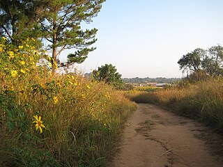
Mwinilunga is a town in the North-Western Province of Zambia. It is the headquarters of Mwinilunga District, one of the province's eleven districts.
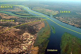
Kazungula is a small border town in Zambia, lying on the north bank of the Zambezi River about 70 kilometres (45 mi) west of Livingstone on the M10 Road.
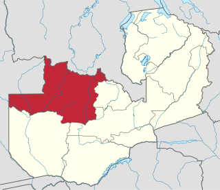
North-Western Province is one of ten Provinces of Zambia. It covers an area of 125,826 km2 (48,582 sq mi), has a population of 727,044 and a population density of 5.80 per square kilometre as of 2010. It is the most sparsely populated province in the country. The provincial capital is Solwezi. The literacy rate stood at 63 per cent against a national average of 70.2 per cent. The rural population constituted 77.45%, while the urban population was 22.55%. North-Western Province is bordered along Angola in the west, the Democratic Republic of Congo in the north, Copperbelt Province in the east, Central in the south-east, and Western Province in the south-west.
Munali Secondary School is a state-funded secondary school located on the Great East Road in Lusaka, Zambia. Munali was the first secondary school for black students in Zambia's history. Some of its alumni are notable Zambian politicians and public figures:
This article gives lists of the National Monuments and other historic sites of Zambia, with a one- or two-line description providing links to details given on other pages.
Christianity has been very much at the heart of religion in Zambia since the European colonial explorations into the interior of Africa in the mid 19th century. The area features heavily in the accounts of David Livingstone's journeys in Central Africa.
The following outline is provided as an overview of and topical guide to Zambia:
Zambia, officially known as the Republic of Zambia, is a landlocked country in Southern Africa. The neighbouring countries are the Democratic Republic of the Congo to the north, Tanzania to the north-east, Malawi to the east, Mozambique, Zimbabwe, Botswana, and Namibia to the south, and Angola to the west. The capital city is Lusaka, located in the southeast of the country. The population is concentrated mainly around the capital and the Copperbelt to the northwest.
Rugby union in Zambia is a minor but growing sport. The Zambia national rugby union team is currently ranked 67th by World Rugby. The Zambia Rugby Football Union has 9880 registered players and three formally organised clubs.
Jethro Mukenge Mutti, was a Zambian politician who between the years 1964 to 1975 served as member of parliament, Ambassador, Minister and Member of the Central Committee under the ruling party UNIP led by Kenneth Kaunda. He died on 18 January 2013 after complications from aspiration pneumonia following a series of mini strokes and poor health in the last few years of his life, linked to his tetraplegic condition.
The T5 is a trunk road in Zambia. It connects Chingola in the Copperbelt Province with Solwezi and Mwinilunga in the North-Western Province. The Route extends to end at the Jimbe border post with Angola. It is the only other road after the M18 Road that connects the towns of the North-Western and Copperbelt provinces and is currently one of the main routes motorists use to reach Angola from Zambia. The first section of the road is a toll road.