Transport in Tanzania includes road, rail, air and maritime networks. The road network is 86,472 kilometres (53,731 mi) long, of which 12,786 kilometres (7,945 mi) is classified as trunk road and 21,105 kilometres (13,114 mi) as regional road. The rail network consists of 3,682 kilometres (2,288 mi) of track. Commuter rail service is in Dar es Salaam only. There are 28 airports, with Julius Nyerere International being the largest and the busiest. Ferries connect Mainland Tanzania with the islands of Zanzibar. Several other ferries are active on the countries' rivers and lakes.

Kagera Region is one of Tanzania's 31 administrative regions. The region covers an area of 35,686 km2 (13,778 sq mi). The region is comparable in size to the land area of the Netherlands. Kagera Region is bordered to the east by Lake Victoria, Mwanza Region and Mara Region. The region is bordered to the south by Geita Region and Kigoma Region. Lastly, Kagera borders Rwanda to the west, Uganda to the north and Burundi to the south west. The regional capital city is Bukoba. According to the 2022 national census, the region had a population of 2,989,299, an increase from 2,458,023 recorded in 2012.

Ruvuma Region is one of Tanzania's 31 administrative regions The region covers a land area of 63,669 km2 (24,583 sq mi). The region is comparable in size to the combined land area of the nation state of Latvia. The region is also bordered to the north by the Morogoro Region, to the northeast by the Lindi Region, to the east by the Mtwara Region,the west by Lake Nyasa with Malawi and to the northwest by the Njombe Region. The regional capital is the municipality of Songea.

Kanungu District is a district in the Western Region of Uganda. The town of Kanungu is the site of the district headquarters. The Bwindi Impenetrable Forest in Kanungu District is among the sites shown in aerial footage in the movie Black Panther.

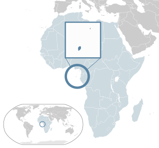
Kigoma Region is one of Tanzania's 31 administrative regions. The regional capital is the city of Kigoma. Kigoma Region borders Kagera Region, Geita Region, Katavi Region, Tabora Region, DRC and Burundi According to the 2012 national census, the region had a population of 2,127,930, which was higher than the pre-census projection of 1,971,332. For 2002-2012, the region's 2.4 percent average annual population growth rate was tied for the fourteenth highest in the country. It was also the sixteenth most densely populated region with 57 people per square kilometer. With a size of 45,066 square kilometres (17,400 sq mi), the region is slightly smaller than Estonia.

Tabora Region is one of Tanzania's 31 administrative regions. The regional capital is the municipality of Tabora. The region is located in mid-western part of Tanzania. Tabora is bordered by Shinyanga to the north, Singida to the east, Mbeya and Songwe to the south. lastly, Katavi, Kigoma and Geita, border Tabora to the west. Tabora is by far the largest region in Tanzania by area. Most of the population in the region is concentrated in the north in Nzega district. According to the 2022 national census, Tabora Region had a population of 3,391,679.

Ngara District is one of the eight districts of the Kagera Region of Tanzania. It is bordered to the north by Karagwe District, to the east by Biharamulo District, to the south by the Kigoma Region, to the northeast by Muleba District and to the west by the countries of Rwanda and Burundi.

Kasulu District is one of the 8 districts of Kigoma Region, Tanzania. The Kasulu District is the rural district council to the Kasulu Town Council which separated from the Kasulu District Council in 2011. It is bordered to the north by Burundi, to the east by Kibondo District, to the south by Uvinza District, to the west by Kigoma District and to the northwest by Buhigwe District. The district consists of lowland forest, and highland grasslands.

The Kuria people (also known as the AbaKurya, are a Bantu community in Tarime District of Mara Region in Tanzania and southern Kenya. Their homeland is bounded on the east by the Migori River and on the west by the Mara River estuary. Traditionally a pastoral and farming community, the Kuria grow maize, beans and cassava as food crops and coffee and maize as cash crops.

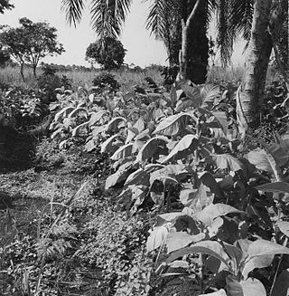
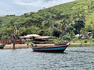
The Ha, also called Abaha, are a Bantu ethnic group found in Kigoma Region in northwestern Tanzania bordering Lake Tanganyika. In 2001, the Ha population was estimated to number between 1 and 1.5 million, making them one of the largest ethnic groups in ethnically diverse Tanzania.

Ngozi is a town located in northern Burundi. It is the largest urban center in the Ngozi Province and the location of the provincial headquarters.

Angola is a potentially rich agricultural country, with fertile soils, a favourable climate, and about 57.4 million ha of agricultural land, including more than 5.0 million ha of arable land. Before independence from Portugal in 1975, Angola had a flourishing tradition of family-based farming and was self-sufficient in all major food crops except wheat. The country exported coffee and maize, as well as crops such as sisal, bananas, tobacco and cassava. By the 1990s Angola produced less than 1% the volume of coffee it had produced in the early 1970s, while production of cotton, tobacco and sugar cane had ceased almost entirely. Poor global market prices and lack of investment have severely limited the sector since independence.
Uganda's favorable soil conditions and climate have contributed to the country's agricultural success. Most areas of Uganda have usually received plenty of rain. In some years, small areas of the southeast and southwest have averaged more than 150 millimeters per month. In the north, there is often a short dry season in December and January. Temperatures vary only a few degrees above or below 20 °C but are moderated by differences in altitude.

Agriculture in the central African country of Burundi produced in 2018:

Lyantonde District is a district in southern Central Uganda. It is named after the 'chief town' of the district, Lyantonde, where the district headquarters are located.

Kasulu Town is the largest city in Kigoma Region, and the fourteenth most populous city in Tanzania with a population of 238,321 as of 2022.
Santomean cuisine comprises the cuisine, dishes and foods of São Tomé and Príncipe, a Portuguese-speaking island nation in the Gulf of Guinea, off the western equatorial coast of Central Africa. The country consists of two archipelagos around the two main islands: São Tomé and Príncipe, located about 140 kilometres (87 mi) apart and about 250 and 225 kilometres, respectively, off the northwestern coast of Gabon.
Agriculture in the Republic of the Congo is mostly at the subsistence level. Self-sufficiency in food production is yet to be achieved. Cassava (manioc) is the basic food crop everywhere in the country except in the southern region, where bananas and plantains are prevalent. Among the cash crops, the most important are sugarcane and tobacco, though palm kernels, cacao, and coffee are also cultivated to some extent. The main consumption crops are bananas, manioc, peanuts, plantains, sugarcane, and yams. Subsistence agriculture is the country's most significant employer, and it is one of the three most important economic sectors. With the government's efforts since 1987, agricultural production has increased due to "abolishing state marketing boards, freeing prices, launching new agricultural credit institutions and closing down most state farms". The Niari Valley in the south is a notable agricultural area.

Agriculture is the main part of Tanzania's economy. As of 2016, Tanzania had over 44 million hectares of arable land with only 33 percent of this amount in cultivation. Almost 70 percent of the poor population live in rural areas, and almost all of them are involved in the farming sector. Land is a vital asset in ensuring food security, and among the nine main food crops in Tanzania are maize, sorghum, millet, rice, wheat, beans, cassava, potatoes, and bananas. The agricultural industry makes a large contribution to the country's foreign exchange earnings, with more than US$1 billion in earnings from cash crop exports.
Kigoma District is one of the eight administrative districts of Kigoma Region in Tanzania. The district lies north of the city of Kigoma-Ujiji. Uvinza District, to the west and south of Ujiji, was split off from the Kigoma District in 1 July, 2013.
