Matengo people

Last updated
Map showing the approximate location of the Matengo Highlands in Tanzania Matengo Highlands of Tanzania.png
Map showing the approximate location of the Matengo Highlands in Tanzania

The Matengo are an ethnic and linguistic group based in Mbinga District, [1] Ruvuma Region in southern Tanzania. In 1957, the population estimate was 57,000, [2] while in 2010, the Matengo population was estimated to number 284,000. Their religious affiliation is to Christianity. Their Affinity Bloc is Sub-Saharan African. Their main language is Matengo, [3] [4] which is one of the Bantu languages. [5]

Contents

History

The Matengo people are believed to have lived in the Matengo Highlands since the Iron Age. [6]

The area in which they live was invaded by the Maseko Ngoni people of the Dedza district of Malawi [7] prior to 1750. [8] This forced the Matengo people further into the mountainous areas around Litembo where many moved into caves. [9] Many people moved in the northeastern part of the district into the woodland. [10] During the pressure from the Ngoni people, the Matengo developed a hierarchy of power amongst their peoples, with a senior chief in charge of three local chiefs. [10] This system was strong during the colonial period until shortly before independence in 1961. In the late 1960s, a dramatic population increase amongst the Matengo peoples of the region led to food shortages, which had a direct impact upon the distribution of the people, with many moving to the eastern part of the district and forming new villages to farm the land seasonally.

Demographics

Mbinga district comprises four ethnic groups namely the Matengo, the Ngoni, the Manda and Nyasa and the Matengo constitute 60% of the population with a population density of 34 people/km², as of 2000. Specifically, in the Matengo Highlands the Matengo population density was reported to be 120/km². As a result, there is pressure on land use, which has resulted in people migrating from the highlands to the woodlands in the northeastern region. [10]

Socio-political setup

The "Socio geographic units" of the Matengo originally consisted of a political organization which was "non-hierarchical, comprising a collectivity of sovereign matrilineal groups of equivalent status and diverse origins. Each such patrilineal group (kilau) represented the descendants of a common grandfather, who during his lifetime had been the unquestioned leader (matukolu or bambo) of the group." Thus, the socio-political set up in the villages consisted of a headman and elders. However, after the Ngonis' invaded their territory, the Matengos' political hierarchy also evolved into an administrative system comprising a paramount chief followed by three chiefs, senior headman and two levels of headman, in the descending order of their importance in the hierarchy. During the colonial administration, this set up was strengthened. However, subsequent to independence of Tanzania in 1961, the patronymic unit (kilau) is retained only for the purpose of naming the family siblings. The present administrative set up in the village consists of a "Village Chairman" with a complement of members to administer the village under the control of the local government authorities and the central government. [10]

Language

Matengo is a "middle sized language", an offshoot of the Bantu language that is commonly spoken in the southwestern corner of Tanzania. Bantu speakers are also known as "people of the woods" (a derivative from the word ‘kitengo’ meaning "dense forest"). However, the Swahili words have influenced the Matengo, particularly the lexicon. Grammar and phonology of Matengo have undergone change under Swahili influence; a certain amount of code mixing has also occurred. The Matengo language is thus getting Swahilized gradually, and as result most of the younger generation tend to speak in Swahili. [10] [11]

Climate and agriculture

The Matengo people inhabit the southern highlands of Tanzania, a mountainous area of the country which ranges in altitude from 900 to 2000 metres above sea level. The land below an altitude of 1400 metres is generally open woodland known as miombo, with a heavy concentration of Caesalpiniaceae trees. The climate is typically cool, averaging a temperature of 18 °C annually and is relatively wet, with an average annual rainfall of about 1000 mm. [2]

The traditional farming methods of the Matengo are known as Ingolo or Ngolo. [9] Over the last 100 years, the Matengo have developed an innovative method of farming on the steep hills, digging pits on ridges on steep slopes to prevent soil erosion and to promote sustainable fertile soils. [9] [12] The function of the pits is to prevent heavy rain washing away the soils on the steep slopes, acting as sedimentation tanks to trap green grasses, thus providing a source of nutrients for the following season. The main crops they grow are staple food crops and coffee under this unique system of cultivation known as "Matengo Pit Cultivation". This cultivation practice usually starts in March following the rainy season. [13] [14] Their method involves a 2-year one-cycle rotation of crops, with a short-fallow period, generally maize, beans and peas. [15] For example, with maize farming amongst the Matengo, in November a farmer will make furrows of roughly 5 centimetres on the ridges and sow the seeds, and commence weeding in December. The maize is then harvested in July and then the field is reduced to fallow until the following March to allow the soils to recover. [15] If the planting of beans is delayed, cassava is often planted in the April or May. Often, the fields may only contain cassava which is known to the Matengo as "kibagu" and is generally grown for 2–3 years. [13] Like sweet potato, cassava is often grown to increase food supply during bad harvests. [13] It is common for fields to contain a mix of maize and beans and to a lesser extent cassava. Unlike maize, the beans are harvested earlier in the season in the March. [13] Some are also known to cultivate onions, cabbage, Chinese cabbage and tomato. [16]

While practicing a sedentary agriculture style in the country's mountainous region, the Matengo also cultivate the cash crop of coffee. It was introduced to Mbinga District in the 1920s by the son of ex-Paramount chief Yohani Chrisostomus Makita Kayuni to enable the Matengo to pay poll tax, a demand of the colonial administration. [17] Since then, the district has developed coffee sustainability due to its cold and wet climatic conditions, which has resulted in the district becoming a major coffee-producing region in Tanzania. This has also improved the economic condition of the people with some families becoming very rich. [1] [14] [18] In the past, the Mbinga Cooperation Union (MBICU) was responsible for supporting the coffee industry amongst the Matengo farmers. However, in 1993, following economic liberalisation, they filed for bankruptcy as they could not compete with the private growers. [1]

Social practices

The Matengo society follows the patrilineal hierarchy and is polygamous. The land holding of each family is normally a small ridge of the hill region adjoining streams for supply of water for cultivation. The land they cultivate is termed as "ntumbo". Married women hire the ntumbo land from their father-in-law and are usually engaged in growing staple food crops such as maize and beans. They also raise livestock of cattle and pigs to supplement their income. The men, however, exclusively grow coffee, as cash crop to ensure economic prosperity. [14]

Musical changes that have occurred here are a reflection of economic and political changes as well as the gendered decision of the highland dancers. [19]

Matengo people live in one-room jiko (house) tenements which serve as their kitchen, dining room, and favourite place to entertain guests. Ugali, is their main daily diet which is thick corn porridge; fish or meat are also added to the ugali. [20]

Folklore

Folklore is rich amongst the Matengo and folk tales are passed on from generation to generation orally. The folk tales of Matengo people have been recorded by Catholic missionaries, and Fr. Johannes P. Häfliger was the first person to publish some of folk tales. Motengo language as such does not have any script and does not have a uniform system for its sounds. Hence, all tales narrated are an oral rendition, which are translated into English. These generally involve animals or families. Notable Matengo folklore tales include "Hare and the Great Drought," "How Hare Helped Civet," and "What Hare Did To Lion and Hyena", "Hare, Civet and Antelope", "The Tale of Two Women", "The Tale of an Uncle and his Nephew", the "Tale of Nokamboka", "Katigija," "Hawk and Crow," and "The Monster in the Rice Field." The traditional folk story that is often narrated is the "How Hare Helped Civet," which is about a naive African cat, his friend Lion, who hoodwinks him and tricks him, and Hare, also a con artist who outwits the Lion and extorts retribution for Civet. Joseph Mbele has published a book of these folktales, translated into English. [20] [21] [22]

Related Research Articles

<span class="mw-page-title-main">Ruvuma Region</span> Region of Tanzania


Ruvuma Region(Mkoa wa Ruvuma in Swahili) is one of Tanzania's 31 administrative regions The region covers a land area of 63,669 km2 (24,583 sq mi). The region is comparable in size to the combined land area of the nation state of Latvia. The region is also bordered to the north by the Morogoro Region, to the northeast by the Lindi Region, to the east by the Mtwara Region,the west by Lake Nyasa with Malawi and to the northwest by the Njombe Region. The regional capital is the municipality of Songea.
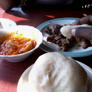
<span class="mw-page-title-main">Ugali</span> Type of maize meal made in Africa

Ugali or posho or sima is a type of corn meal made from maize or corn flour in several countries in Africa. Sima is sometimes made from other flours, such as millet or sorghum flour, and is sometimes mixed with cassava flour. It is cooked in boiling water or milk until it reaches a stiff or firm dough-like consistency. In 2017, the dish was added to the UNESCO Representative List of the Intangible Cultural Heritage of Humanity, one of a few foods in the list.

<span class="mw-page-title-main">Mara Region</span> Region of Tanzania

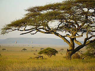
Mara Region is one of Tanzania's 31 administrative regions. The region covers an area of 21,760 km2 (8,400 sq mi). The region is comparable in size to the combined land area of the nation state of El Salvador. The neighboring regions are Mwanza Region and Simiyu Region, Arusha Region, and Kagera Region. The Mara Region borders Kenya .The regional capital is the municipality of Musoma. Mara Region is known for being the home of Serengeti National Park, a UNESCO World Heritage site and also the birth place of Tanzania's founding father Julius Nyerere. Under British colonial occupation, the Mara Region was a district called the Lake Province, which became the Lake Region after independence in 1961.

<span class="mw-page-title-main">Karagwe District</span> District of Kagera Region, Tanzania

Karagwe is one of the eight districts of the Kagera Region of Tanzania. It is bordered to the north by Uganda, to the east by the Bukoba Rural District, to the southeast by the Muleba District, to the south by the Ngara District and to the west by Republic of Rwanda, from which it is divided by the River Kagera. Small lakes such as the Ikimba, Burigi, Rushwa, and Rwakajunju provide fishing opportunities for residents of the Karagwe District. The district covers and area of 5,134 square kilometres (1,982 sq mi).

<span class="mw-page-title-main">Marakwet people</span>

The Marakwet are one of the groups forming the ethnolinguistic Kalenjin community of Kenya, they speak the Markweta language. The Marakwet live in five territorial sections namely Almoo, Cherangany, Endoow, Sombirir (Borokot) and Markweta. Cutting across these territorial groups are a number of clans to which each Marakwet belongs. There were 119,969 Marakwet people in 2019.

<span class="mw-page-title-main">Turu people</span> Ethnic and linguistic group based in the Singida Region of north-central Tanzania

The Turu are an ethnic and linguistic group based in the Singida Region of north-central Tanzania who speak Bantu language Kinyaturu. In 1993, the Turu population was estimated to number 556,000.. The current population of the Turu is now over 1,000,000. They speak the Turu language.

<span class="mw-page-title-main">Kuria people</span> Ethnic group from Mara Region of Tanzania

The Kuria people (also known as the AbaKurya, are a Bantu community in Tarime District of Mara Region in Tanzania and southern Kenya. Their homeland is bounded on the east by the Migori River and on the west by the Mara River estuary. Traditionally a pastoral and farming community, the Kuria grow maize, beans and cassava as food crops and coffee and maize as cash crops.

<span class="mw-page-title-main">Ha people</span> Ethnic group from Kigoma Region, Tanzania

The Ha, also called or Abaha, are a Bantu ethnic group found in Kigoma Region in northwestern Tanzania bordering Lake Tanganyika. In 2001, the Ha population was estimated to number between 1 and 1.5 million, making them one of the largest ethnic groups in ethnically diverse Tanzania.

<span class="mw-page-title-main">Agriculture in Angola</span>

Angola is a potentially rich agricultural country, with fertile soils, a favourable climate, and about 57.4 million ha of agricultural land, including more than 5.0 million ha of arable land. Before independence from Portugal in 1975, Angola had a flourishing tradition of family-based farming and was self-sufficient in all major food crops except wheat. The country exported coffee and maize, as well as crops such as sisal, bananas, tobacco and cassava. By the 1990s Angola produced less than 1% the volume of coffee it had produced in the early 1970s, while production of cotton, tobacco and sugar cane had ceased almost entirely. Poor global market prices and lack of investment have severely limited the sector since independence.

<span class="mw-page-title-main">Agriculture in Madagascar</span> Economic sector in Madagascar

Agriculture employs the majority of Madagascar's population. Mainly involving smallholders, agriculture has seen different levels of state organisation, shifting from state control to a liberalized sector.

<span class="mw-page-title-main">Chitemene</span>

Chitemene, from the ciBemba word meaning “place where branches have been cut for a garden”, is a system of slash and burn agriculture practiced throughout northern Zambia. It involves coppicing or pollarding of standing trees in a primary or secondary growth Miombo woodland, stacking of the cut biomass, and eventual burning of the cut biomass in order to create a thicker layer of ash than would be possible with in situ burning. Crops such as maize, finger millet, sorghum, or cassava are then planted in the burned area.

<span class="mw-page-title-main">Matengo Highlands</span>

The Matengo Highlands are located in the western part of the mountainous area of Mbinga District, Ruvuma Region in southern Tanzania. They are home to the Matengo people. Kindimba is the historical center of the highlands. It is located on highland's western side, approximately 15 km west of Mbinga. Its subvillages include Kindimba, Kitanda, Mkanya, Mutugu, Ndembo, Torongi, Walarzi. In 2006, the total Kindimba population was 2440. Other towns and villages include Litembo and Lipumba.

Kindimba is a village in Mbinga district in the Ruvuma Region of the Tanzanian Southern Highlands. It is the historical centre of the Matengo Highlands and of the Matengo people. It is located on highland's western side, approximately 15 kilometres (9.3 mi) west of Mbinga.In 2006, the total Kindimba population was 2,440.

Lipumba is a village in Mbinga district in the Iringa Region of the Tanzanian Southern Highlands. It is located in the Matengo Highlands and is inhabited by the Matengo people. Lipumba is located to the northeast of the town of Mbinga and lies off the A19 road which connects it to Songea in the east.

Litembo is a village in Mbinga district in the Ruvuma Region of the Tanzanian Southern Highlands. It is located in the Matengo Highlands and is inhabited by the Matengo people. Litembo is located to the southwest of the town of Mbinga. It contains the Litembo Diocesan Hospital.

<span class="mw-page-title-main">Burundian cuisine</span> Culinary traditions of Burundi

Burundi is situated in East Africa and has a territory full of mountains, savannas and agricultural fields, with forests in the surrounding rivers and waters. Agriculture is spread on 80% of the country's surface and it mainly includes coffee, tea, maize, beans and manioc. Due to these characteristics, Burundi cuisine is very representative of the African culinary culture, as it includes beans, which are the staple of Burundi cooking, exotic fruits, plantains, sweet potatoes, cassava, peas, maize and cereals, like corn and wheat.

<span class="mw-page-title-main">Coffee production in Tanzania</span>

Coffee production in Tanzania is a significant aspect of its economy as it is Tanzania's largest export crop. Tanzanian coffee production averages between 30,000 and 40,000 metric tons annually of which approximately 70% is Arabica and 30% is Robusta.

<span class="mw-page-title-main">Agriculture in Tanzania</span>

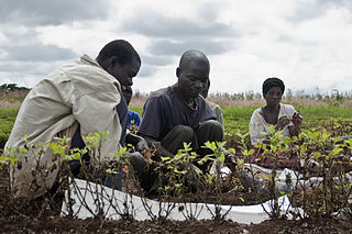
Agriculture is the main part of Tanzania's economy. As of 2016, Tanzania had over 44 million hectares of arable land with only 33 percent of this amount in cultivation. Almost 70 percent of the poor population live in rural areas, and almost all of them are involved in the farming sector. Land is a vital asset in ensuring food security, and among the nine main food crops in Tanzania are maize, sorghum, millet, rice, wheat, beans, cassava, potatoes, and bananas. The agricultural industry makes a large contribution to the country's foreign exchange earnings, with more than US$1 billion in earnings from cash crop exports.

<span class="mw-page-title-main">Buhigwe District</span> District of Kigoma Region, Tanzania

Buhigwe District is one of the eight districts of the Kigoma Region of Tanzania. It is one of the 20 new districts that were formed in Tanzania since 2010; it was split off from Kasulu Rural District. Buhigwe District is bordered to the north by Burundi, to the east by Kasulu Rural District and Kasulu Urban District, and to the west by Kigoma Rural District. Its administrative seat is the town of Buhigwe.

The Lala people are a Bantu ethnic group found in the Serenje District of the Central Province of Zambia.

References

  1. 1 2 3 Kurosaki, p.20
  2. 1 2 Kurosaki, p. 21
  3. "Matengo". Joshua Project: A ministry of the U.S. Center for World Mission . Retrieved 2010-10-25.
  4. "Languages of Tanzania". Ethnologue:Languages of the World. Retrieved 25 October 2010.
  5. Kurosaki, p.19
  6. Mwaura, Peter (2008). "Indigenous Knowledge in Disaster Management in Africa". United Nations Environment Programme. p. 7. Retrieved 25 October 2010.
  7. Linden, Ian (March 29, 2010). "NGONI PEOPLE OF MALAWI, MOZAMBIQUE, TANZANIA AND ZAMBIA". ngonipeople.com. Retrieved 26 October 2010.
  8. Kimambo, p. 188
  9. 1 2 3 "Change and stability in the indigenous farming" (PDF). TZ Online. Retrieved 25 October 2010.
  10. 1 2 3 4 5 Kimambo, Isaria N. (2008). Contemporary perspectives on African moral economy. African Books Collective. pp. 184–6. ISBN   978-9976-60-465-8.
  11. ""Swahilization" of Ethnic Languages in Tanzania:The Case of Matengo" (PDF). Research Institute for World Languages, Osaka University. Retrieved 2010-10-26.
  12. Nhira & Mapiki, p.258
  13. 1 2 3 4 Kurosaki, p.23
  14. 1 2 3 Kato, Masahiko (July 2001). "Intensive cultivation and environment use among the Matengo in Tanzania". African Study Monographs. africa.kyoto-u.ac.jp. 22 (1): 2.
  15. 1 2 Kurosaki, p.22
  16. Kurosaki, p.26
  17. Kimambo, pp. 187–188
  18. "African Proverb of the Month, November, 2005". Afriprov.org. Retrieved 25 October 2010.
  19. Hill, Stephen (Winter 2001). "Journal:Africa Today". Africa Today. Project MUSE. 48 (4). ISSN   0001-9887.
  20. 1 2 "A Matengo Childhood". Thomsons Safaris News letter. Archived from the original on 2009-10-04. Retrieved 2010-10-26.
  21. Mbele, Joseph. "Matengo Folktales". NTZ. Retrieved 25 October 2010.
  22. "Matengo Folktales". ntz.info. Archived from the original on 2012-09-06. Retrieved 2010-10-25.{{cite web}}: CS1 maint: bot: original URL status unknown (link)

Bibliography